The Adirondack picture map


Item Information
- Title:
- The Adirondack picture map
- Title (alt.):
-
Picture map of the Adirondacks, Lake George and Lake Champlain : showing the great macadam road system
- Author:
- Knight, Edward Arthur, 1865-1921
- Copyright holder:
- Knight, Arthur S., 1894-1976
- Publisher:
- Lake George Printing Company
- Date:
-
[1921]
- Format:
-
Maps/Atlases
- Location:
-
Boston Public Library
Norman B. Leventhal Map & Education Center - Collection (local):
-
Norman B. Leventhal Map & Education Center Collection
- Subjects:
-
Adirondack Mountains (N.Y.)--Maps
Champlain, Lake--Maps
Roads--New York (State)--Adirondack Mountains--Maps
- Places:
-
New YorkAdirondack Mountains
Champlain, Lake
- Extent:
- 1 map : color ; 51 x 33 cm, on sheet 56 x 36 cm, folded to 19 x 9 cm
- Terms of Use:
-
No known copyright restrictions.
No known restrictions on use.
- Publisher:
-
Lake George, N.Y. :
Lake George Printing Co.
- Scale:
-
Scale not determined
- Language:
-
English
- Notes:
-
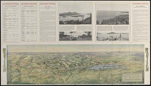
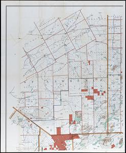
Relief shown by gradient tints.
Shows good graded roads, common dirt roads, macadam roads in New York state, fine gravel roads in Vermont, and railroads.
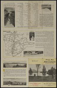
On verso: text (written by E.A. Knight shortly before his death), illustrations, business directory, and Map of good roads leading to the Adirondacks.
"Compliments of Chazy Landing Ferry"--Verso.
- Notes (date):
-
This date is inferred.
- Identifier:
-
06_01_019125
- Call #:
-
G3802.A2 1921 .K55
- Barcode:
-
39999085971339