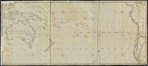
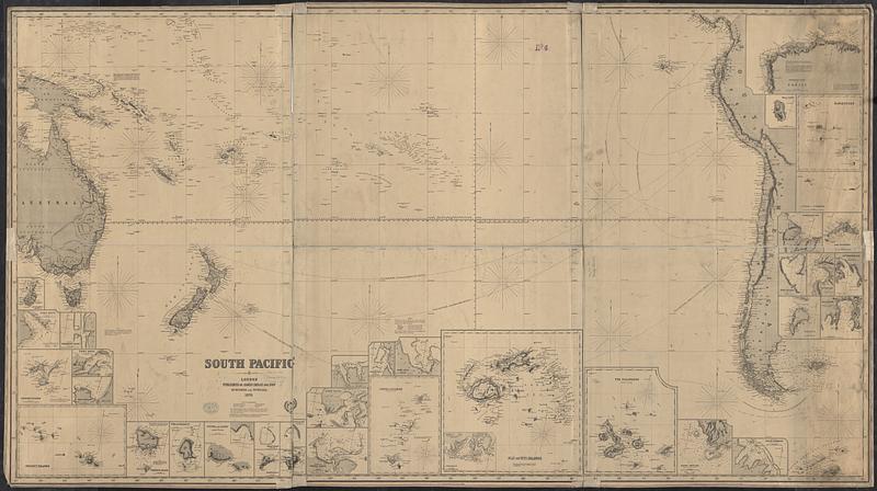
South Pacific
Item Information
- Title:
- South Pacific
- Cartographer:
- Imray, James F. (James Frederick), 1829?-1891
- Publisher:
- James Imray and Son
- Name on Item:
-
compiled by James F. Imray, F.R.G.S.
- Date:
-
[1871]
- Format:
-
Maps/Atlases
- Genre:
-
Nautical charts
- Location:
-
Boston Public Library
Norman B. Leventhal Map & Education Center - Collection (local):
-
Norman B. Leventhal Map & Education Center Collection
- Subjects:
-
South Pacific Ocean--Maps
Nautical charts--South Pacific Ocean
- Places:
-
South Pacific
- Extent:
- 1 map on 3 sheets : joined ; 101 x 182 cm
- Terms of Use:
-
No known copyright restrictions.
No known restrictions on use.
- Publisher:
-
London :
James Imray and Son
- Scale:
-
Scale approximately 1:10,000,000
- Language:
-
English
- Notes:
-
Relief shown by hachures and spot heights. Depth shown by isolines and soundings.
Hydrographic chart of the south Pacific Ocean, from eastern Australia and Papua New Guinea to South America.
"Published by James Imray & Son, 89 & 102, Minories, London, 1863."--Margin of middle and right sheets.
"Published by James Imray & Son, 89 Minories and Tower Hill, 1870."--Below title on left sheet.
"Imray & Son, 1871, London."--Stamped below title on left sheet.
Includes 35 insets: Auckland Is. Scale approximately 1:875,000 -- Port Hutt. Scale approximately 1:29,500 -- Sketch of Ohamaneno Harbr. Scale approximately 1:99,000 -- Chatham Islands. Scale approximately 1:1,036,000 -- Port Ross. Scale approximately 1:155,500 -- Port Waïtangi. Scale approximately 1:42,000 -- Society Islands. Scale approximately 1:2,000,000 -- Norfolk Island. Scale approximately 1:161,500 -- Uvea or Wallis Id. Scale approximately 1:259,000 -- Futuna and Alofa, or Horne Islands. Scale approximately 1:270,500 -- Scilly Island. Scale approximately 1:280,000 -- Mopelia Isld. Scale approximately 1:280,000 -- Easter Island. Scale approximately 1:714,000 -- Erronan or Futuna Id. Scale approximately 1:115,000 -- Sketch of Taloo & A-voi-tai Bays. Scale approximately 1:130,000 -- Port Vavao. Scale approximately 1:92,000 -- Harbour of Tonga-Tabou. Scale approximately 1:259,000 -- Sketch of Owharre Harbr. Scale approximately 1:63,000 -- Port Apia. Scale approximately 1:29,500 -- Tonga Islands. Scale approximately 1:2,100,000 -- Fiji or Viti Islands. Scale approximately 1:2,150,000 -- The Galapagos. Scale approximately 1:1,650,000 -- Port Inyang. Scale approximately 1:96,500 -- Sketch of Oopoa Harbour. Scale approximately 1:108,000 -- North-west coast of Tahiti. Scale approximately 1:119,000 -- Mas-a-fuera. Scale approximately 1:310,500 -- Marquesas. Scale approximately 1:2,175,000 -- St. Felix and St. Ambrose. Scale approximately 1:248,500 -- Cumberland Bay. Scale approximately 1:55,500 -- Juan Fernandez. Scale approximately 1:235,000 -- Port Taï-hoa. Scale approximately 1:21,000 -- Vaitahu Bay. Scale approximately 1:30,000 -- Controleur Bay. Scale approximately 1:95,000 -- Tahuata. Scale approximately 1:245,000 -- Tai-o-haé Bay. Scale approximately 1:46,500
- Notes (date):
-
This date is inferred.
- Identifier:
-
06_01_017471
- Call #:
-
G9251.P5 1871 .I47
- Barcode:
-
39999085959466