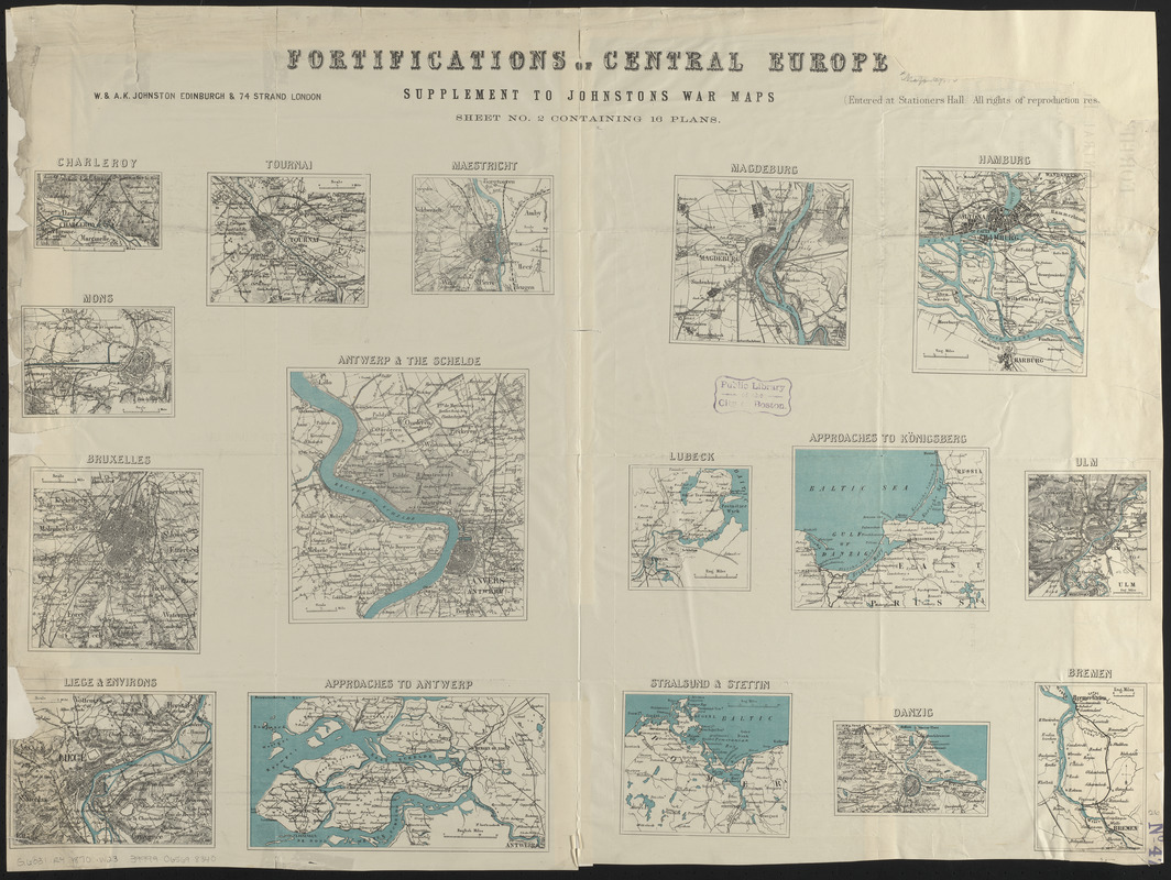
Fortifications of Central Europe : sheet no. 2 containing 16 plans
Item Information
- Title:
- Fortifications of Central Europe : sheet no. 2 containing 16 plans
- Publisher:
- W. & A.K. Johnston Limited
- Date:
-
1870
- Format:
-
Maps/Atlases
- Location:
-
Boston Public Library
Norman B. Leventhal Map & Education Center - Collection (local):
-
Norman B. Leventhal Map & Education Center Collection
- Subjects:
-
Antwerp (Belgium)--Maps
Bremen (Germany)--Maps
Brussels (Belgium)--Maps
Charleroi (Belgium)--Maps
Gdańsk (Poland)--Maps
Hamburg (Germany)--Maps
Kaliningrad (Kaliningradskai︠a︡ oblastʹ, Russia)
Liège (Belgium)--Maps
Lübeck (Germany)--Maps
Maastricht (Netherlands)--Maps
Magdeburg (Germany)--Maps
Mons (Belgium)--Maps
Szczecin (Poland)
Stralsund (Germany)--Maps
Tournai (Belgium)--Maps
Ulm (Germany)--Maps
- Places:
-
BelgiumFlanders (region)Antwerpen (province)Antwerp
GermanyBremenBremen
BelgiumBrussels-Capital Region (region)Brussels
BelgiumWallonia (region)Hainaut, Province de (province)Charleroi
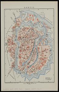
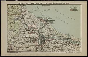
PolandDanzig
GermanyHamburgHamburg
RussiaKaliningrad
BelgiumWallonia (region)Liège (province)Liege
NetherlandsLimburg (province)Maastricht
GermanySaxony-AnhaltMagdeburg
BelgiumWallonia (region)Hainaut, Province de (province)Mons
PolandSzczecin
GermanyMecklenburg-VorpommernStralsund
GermanyBaden-WürttembergUlm
BelgiumWallonia (region)Hainaut, Province de (province)Tournai
GermanySchleswig-HolsteinLubeck
- Extent:
- 16 maps on 1 sheet : color ; sheet 64 x 86 cm
- Terms of Use:
-
No known copyright restrictions.
No known restrictions on use.
- Publisher:
-
London :
W. & A.K. Johnston
- Scale:
-
Scales differ
- Language:
-
English
- Table of Contents:
-
Charleroy
Tournai
Maestricht
Mons
Bruxelles
Antwerp & the Schelde
Liege & environs
Approaches to Antwerp
Magdeburg
Hamburg
Lubeck
Approaches to Königsberg
Ulm
Stralsund & Stettin
Danzig
Bremen.
- Notes:
-
Relief shown by hachures.
"Supplement to Johnstons war maps."
- Identifier:
-
06_01_013999
- Call #:
-
G6031.R4 1870 .W23
- Barcode:
-
39999065698340