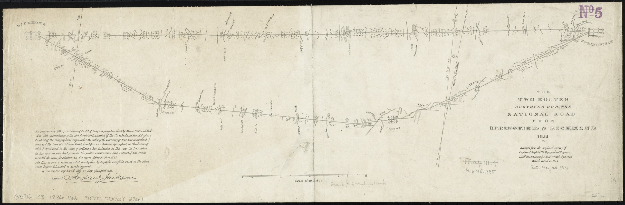
The two routes surveyed for the National Road from Springfield to Richmond, 1835 : reduced from the original survey of Captain A. Canfield, U.S. Topographical Engineer, Lieuts. J.E. Johnston & J.W. McCrabb
Item Information
- Title:
- The two routes surveyed for the National Road from Springfield to Richmond, 1835 : reduced from the original survey of Captain A. Canfield, U.S. Topographical Engineer, Lieuts. J.E. Johnston & J.W. McCrabb
- Creator:
- Hood, Washington.
- Name on Item:
-
by Lieut. Wash. Hood, U.S.A.
- Date:
-
[1836]
- Format:
-
Maps/Atlases
- Location:
-
Boston Public Library
Norman B. Leventhal Map & Education Center - Collection (local):
-
Norman B. Leventhal Map & Education Center Collection
- Subjects:
-
Roads--Ohio--Maps
Cumberland Road--Maps
Ohio--Maps
- Places:
-
Ohio
- Extent:
- 1 map ; 21 x 64 cm
- Terms of Use:
-
No known copyright restrictions.
No known restrictions on use.
- Publisher:
-
Washington, D.C :
U.S. Cong.
- Scale:
-
Scale [ca. 1:163,200]
- Language:
-
English
- Notes:
-
Imprint from NUC pre-1956 cited below.
Detached from U.S. 24th Cong., 1st Sess., 1835-1836, H. Doc. 62. Ser. 288.
Includes 10 lines of text with facsimile signature of Andrew Jackson.
- Notes (date):
-
This date is inferred.
- Identifier:
-
06_01_011190
- Call #:
-
G3712.C8 1836 .H66
- Barcode:
-
39999065682567


