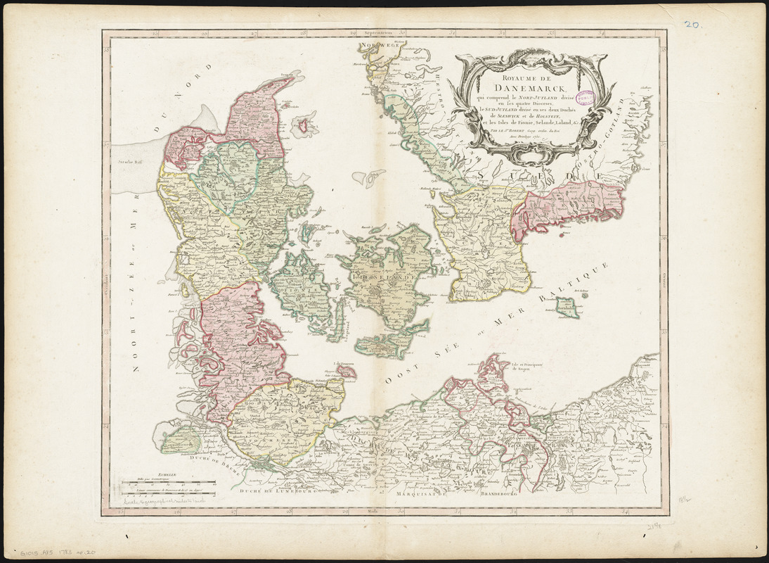
Royaume de Danemarck : qui comprend le Nort-Jutland divisé en ses quatre dioceses, le Sud-Jutland divisé en ses deux duchés de Sleswick et de Holstein, et les isles de Fionie, Selande, Laland, &c
Item Information
- Title:
- Royaume de Danemarck : qui comprend le Nort-Jutland divisé en ses quatre dioceses, le Sud-Jutland divisé en ses deux duchés de Sleswick et de Holstein, et les isles de Fionie, Selande, Laland, &c
- Creator:
- Robert de Vaugondy, Gilles, 1688-1766
- Cartographer:
- Robert de Vaugondy, Gilles, 1688-1766
- Name on Item:
-
par le Sr. Robert, Géogr. ordin. du Roi
- Date:
-
1750
- Format:
-
Maps/Atlases
- Location:
-
Boston Public Library
Norman B. Leventhal Map & Education Center - Collection (local):
-
Norman B. Leventhal Map & Education Center Collection
- Subjects:
-
Denmark--Maps
- Places:
-
Denmark
- Extent:
- 1 map : hand colored ; 47 x 55 cm
- Terms of Use:
-
No known copyright restrictions.
No known restrictions on use.
- Publisher:
-
[Paris] :
[Gilles Robert de Vaugondy]
- Scale:
-
Scale approximately 1:1,180,000
- Language:
-
French
- Notes:
-
Relief shown pictorially.
Also covers part of southern Sweden.
Conservation of this piece was funded by Alan and Sherry Leventhal in memory of his father, Norman B. Leventhal whose vision to create this Map Center will inspire generations to come.
Ma 20 in a composite atlas with the title "Atlas of the world."
- Identifier:
-
06_01_014678
- Call #:
-
G1015 .A85 1783
- Barcode:
-
30000004730315