A new map of New England, New York, New Iarsey, Pensilvania, Maryland and Virginia
Item Information
- Title:
- A new map of New England, New York, New Iarsey, Pensilvania, Maryland and Virginia
- Description:
-
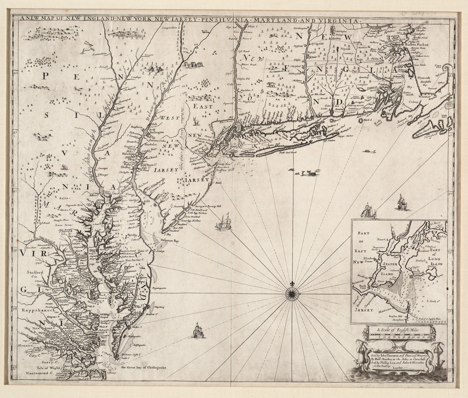
England's widening sphere of influence in eastern North America is reflected on a late 17th century map published in London. By this time, the British had extended their territorial claims from the original Chesapeake and New England colonies into the Hudson and Delaware valleys. The latter areas had been controlled by the Dutch until 1674 when the British captured New Amsterdam (renamed New York in the harbor inset). The map's three contributors, working members of the rapidly growing map trade in London, had access to government sources and records, as well as updated information from traders and sea captains who had recently returned from their voyages. In New England, the map identifies the numerous British settlements in eastern Massachusetts from Boston Harbor south to Cape Cod, along the southern coastal areas, and in the interior along the Connecticut River.
- Creator:
- Thornton, John, 1641-1708
- Contributor:
- Morden, Robert, d. 1703
- Name on Item:
-
sold by Iohn Thornton ... by Robt. Morden ... and by Phillip Lea at ye Atlas & Herculus in the poultry
- Date:
-
1685
- Format:
-
Maps/Atlases
- Location:
- Private Collection
- Collection (local):
-
Mapping Boston Collection
- Subjects:
-
Middle Atlantic States--Maps--Early works to 1800
Northeastern States--Maps--Early works to 1800
New England--Maps--Early works to 1800
- Places:
-
New England (area)
Middle Atlantic (area)
Northeastern United States (area)
- Extent:
- 1 map ; 50 x 44 cm.
- Terms of Use:
-
No known copyright restrictions.
This work is licensed for use under a Creative Commons Attribution Non-Commercial Share Alike License (CC BY-NC-SA).

- Publisher:
-
London :
Thornton, Morden, and Lea
- Edition:
- 1st state.
- Scale:
-
Scale not given
- Language:
-
English
- Notes:
-
Relief shown pictorially.
Depths shown by soundings.
Includes inset of New York Bay.
- Identifier:
-
05_04_000052
- Barcode:
-
39999052507504


