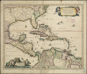
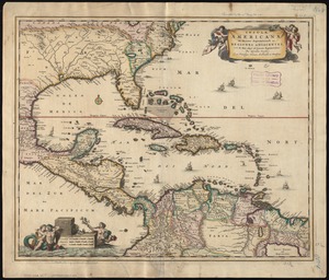
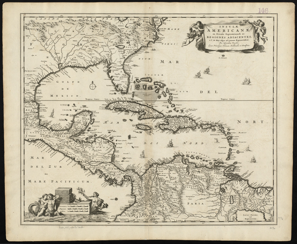
Insulæ Americanæ in Oceano Septentrionali ac regiones adiacentes : a C. de May usque ad Lineam Æquinoctialem
Item Information
- Title:
- Insulæ Americanæ in Oceano Septentrionali ac regiones adiacentes : a C. de May usque ad Lineam Æquinoctialem
- Title (alt.):
-
Collection of old maps
- Creator:
- Visscher, Nicolaes, 1649-1702
- Name on Item:
-
per Nicolaum Visscher
- Date:
-
[ca. 1682]
- Format:
-
Maps/Atlases
- Location:
-
Boston Public Library
Norman B. Leventhal Map & Education Center - Collection (local):
-
Norman B. Leventhal Map & Education Center Collection
- Subjects:
-
West Indies--Maps--Early works to 1800
Central America--Maps--Early works to 1800
- Places:
-
Mesoamerica (area)
West Indies
- Extent:
- 1 map : hand col. ; 45 x 55 cm.
- Terms of Use:
-
No known copyright restrictions.
No known restrictions on use.
- Publisher:
-
Amsterdam :
Visscher
- Scale:
-
Scale [ca. 1:9,936,000]
- Language:
-
Latin
- Notes:
-
Shows the West Indies and Central America from Florida to the northern part of South America, including boundaries, settlements and rivers.
Relief shown pictorially.
Longitude from an unspecificied meridian.
Title and scale in ornamental cartouches.
"Cum Privilegio Ordinum Hollandiæ et Westfrisiæ."
Cataloging, conservation, and digitization made possible in part by The National Endowment for the Humanities: Exploring the human endeavor.
Text in Latin.
State 2 (Burden, P. Mapping of North America II).
Boston Public Library copy is part of composite portfolio atlas with title "Collection of old maps." Each of the 300 maps in this collection is cataloged individually.
- Identifier:
-
06_01_010235
- Call #:
-
G1015 .C651 1630
- Barcode:
-
30000002854960