Noua totius terrarum orbis geographica ac hydrographica tabula
Item Information
- Title:
- Noua totius terrarum orbis geographica ac hydrographica tabula
- Title (alt.):
-
Nova totivs terrarvm orbis geographica ac hydrographica tabvla
Nova totius terrarum
- Description:
-
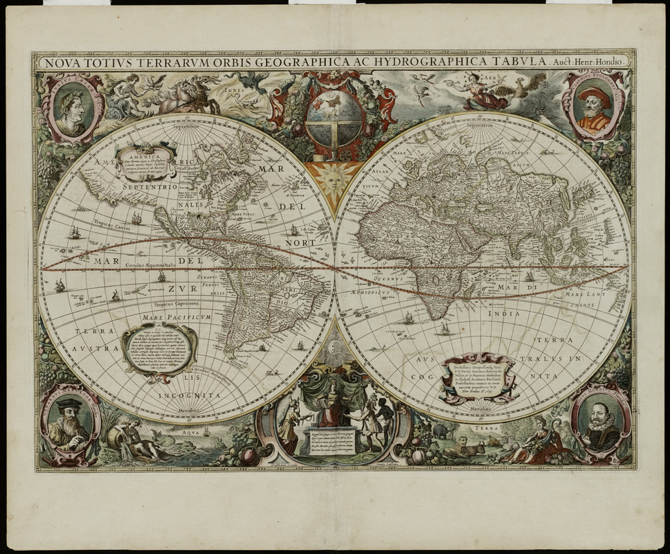
Ornately decorated and beautifully colored, this world map epitomizes the baroque style favored during the Golden Age of Dutch cartography. The map was prepared in 1630 by Henricus Hondius, who had joined in partnership with Jan Jansson to revitalize the map book entitled "Atlas," that was originated by Gerard Mercator in 1595 and continued by Henricus's father Jodocus over the next 35 years. Henricus' world map had a long life as well, appearing in the various editions of the Mercator atlas published from 1633 to 1658. Henricus designed his map using two hemispheres, providing the impression of looking at both sides of a globe at the same time. Although this was not the first time the double hemisphere projection was used for a world map, the longevity of this example most likely provided a precedent for the wide use of this projection throughout the 17th and 18th centuries. The distinguishing feature of this map, however, is the lush ornamentation outside of the two spheres. Vignettes above and below the spheres symbolize the four elements of fire, air, water, and land. In the four corners, there are portraits of Julius Caesar because he ordered a survey of the Roman Empire, the second-century (A.D.) geographer Claudius Ptolemy, and the atlas's first two publishers, Gerard Mercator and Jodocus Hondius, thus establishing Henricus' cartographic lineage and his link to classical geography. In the lower center inset, there is a depiction of the four continents, with the personified Asia, America, and Africa paying tribute to Europe, a theme that was repeated many times on atlas title pages and the marginal map decorations during this time period.
- Creator:
- Hondius, Hendrik, 1597-1651
- Contributor:
- Hondius, Jodocus, 1563-1612
- Contributor:
- Mercator, Gerhard, 1512-1594
- Name on Item:
-
Auct: Henr: Hondio
- Date:
-
1641
- Format:
-
Maps/Atlases
- Location:
- Private Collection
- Collection (local):
-
Mapping Boston Collection
- Subjects:
-
World maps--Early works to 1800
- Places:
-
World
- Extent:
- 1 map : hand col. ; 39 x 54 cm.
- Terms of Use:
-
No known copyright restrictions.
This work is licensed for use under a Creative Commons Attribution Non-Commercial Share Alike License (CC BY-NC-SA).

- Publisher:
-
Amstelodami :
[s.n.]
- Scale:
-
Scale [ca. 1:70,000,000]
- Language:
-
Latin
- Notes:
-
Relief shown pictorially.
Appears in Mercator's Atlas sive cosmographicae meditationes de fabrica mvndi, and in Gerardi Mercatoris et I. Hondii atlas, 1633.
"Weltkarte aus dem Atlas, das ist Abbilung der gantzen Welt mit allen darin begriffenen Ländern und Provintzen' des Gerhard Kremer, gen Mercator (1512-1594) und Jodocus Hondius (1563-1612). Bearbeitet (1630) und herausgegeben von Henricus Hondius, Amsterdam 1633, Originalgrösse : 59 x 41.5 cm."
- Notes (exhibitions):
-
Exhibited: "Journeys of the Imagination" organized by the Norman B. Leventhal Map Center at the Boston Public Library, 2006.
- Identifier:
-
05_01_000221
- Barcode:
-
39999052509609


![Hemispheriu[m] ab aequinoctiali linea, ad circulu[m] Poli Arctici](https://bpldcassets.blob.core.windows.net/derivatives/images/commonwealth:3f462s45p/image_thumbnail_300.jpg)

