Noua, et integra vniuersi orbis descriptio
Item Information
- Title:
- Noua, et integra vniuersi orbis descriptio
- Title (alt.):
-
Nova, et integra vniversi orbis descriptio
Nova, et integra universi orbis descriptio
- Description:
-
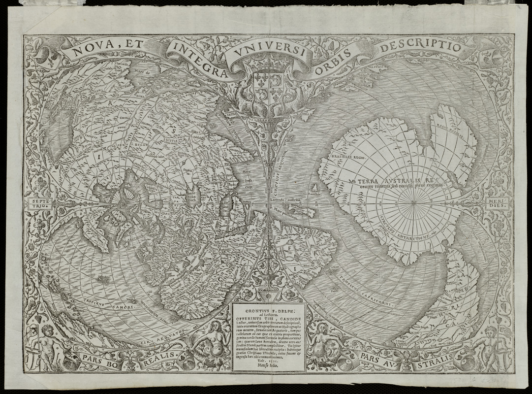
Fine, an eminent French cartographer, created this unique double cordiform or heart-shaped projection, emphasizing the northern and southern hemispheres. The European, Asian and African continents were prominently placed in the center of the left (northern) cordum. However, his treatment of the Americas was somewhat more tentative. By splitting the new World discoveries along the left edge of the northern cordum, it was not obvious that he had depicted these lands as a large peninsula attached to the Asian mainland. While this depiction contradicted Waldseemüller's model, Fine did retain the name America, which appears in the southern part of South America, in the right (southern) cordum. This portion of the map is dominated by a continent that was still speculative. Fine labeled it, "Terra Australis," based on Magellan's relatively recent passage through the strait at the southern tip of South America. A modern redrawing on an oval projection (see below) by Robert W. Karrow helps to clarify the geographic images portrayed on Fine's map. Fine's use of a single cordiform projection in 1519, as well as this use of the double cordiform projection, introduced a tradition of similar world maps throughout the 16th century. While the projection has a mathematical basis, it presents a visually pleasing map. It is also conceivable, since the heart was a widespread Christian symbol, that the use of the heart-shaped projection added religious meaning to the contents of the map.
- Creator:
- Fine, Oronce, 1494-1555
- Contributor:
- Huttich, Johann, 1480?-1544
- Contributor:
- Grynäus, Simon, 1493-1541
- Name on Item:
-
Hermannus Venraed, ad Lectorem, en tibi Candide Lector Geographian hactenus non uisam, accurate[que] impressam Orontius Fineus Delphinates lepido uultu offert ...
- Date:
-
1532
- Format:
-
Maps/Atlases
- Location:
- Private Collection
- Collection (local):
-
Mapping Boston Collection
- Subjects:
-
World maps--Early works to 1800
- Places:
-
World
- Extent:
- 1 map ; 28 x 42 cm.
- Terms of Use:
-
No known copyright restrictions.
This work is licensed for use under a Creative Commons Attribution Non-Commercial Share Alike License (CC BY-NC-SA).

- Publisher:
-
Paris :
[s.n.]
- Scale:
-
Scale not given
- Language:
-
Latin
- Notes:
-
Relief shown pictorially.
Appears in Johann Huttich and Simon Grynaeus' Novus orbis regionum. Paris. 1532.
Exhibited in “Journeys of the Imagination,” at the Boston Public Library, Boston, MA, April - August 2006.
- Identifier:
-
05_01_000214
- Barcode:
-
39999052509575


![Hemispheriu[m] ab aequinoctiali linea, ad circulu[m] Poli Arctici](https://bpldcassets.blob.core.windows.net/derivatives/images/commonwealth:3f462s45p/image_thumbnail_300.jpg)

