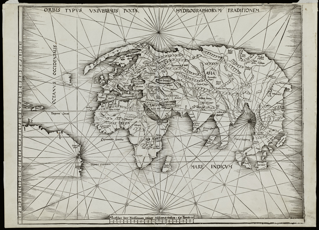
Orbis typus uniuersalis iuxta hydrographorum traditionem
Item Information
- Title:
- Orbis typus uniuersalis iuxta hydrographorum traditionem
- Title (alt.):
-
Orbis typus universalis iuxta hydrographorum traditionem
Orbis typvs vniversalis ivxta hydrographorvm traditionem
- Description:
-
Waldseemüller may have had second thoughts about his 1507 proposal for naming the new continent "America." In 1513, he issued a fourth publication, a new edition of Claudius Ptolemy's Geographia. In it he included contemporary world and regional maps as well as the traditional 27 found in the first printed versions of the Geographia. Surprisingly, his "modern world map" is not a reduced version of his original 1507 map of the world. Waldseemüller's 1513 map, often referred to as the "Admiral's Map," reportedly reflects Columbus' interpretation of the New World discoveries. Consequently, the map focuses on the Caribbean islands and northern South America, which is placed at the map's western margins with no indication of a western coastline. The name "America" is excluded in this updated world map. Substantiating this retraction is another map in the same volume. On the regional map of the Caribbean and Atlantic Ocean (Tabula Terre Nove), South America is labeled "Terra Incognita" (unknown land) and bears an inscription indicating that these lands were discovered by Columbus, with no indication of Amerigo Vespucci's role in the exploration of the northern coast of South America.
- Creator:
- Waldseemüller, Martin, 1470-1519?
- Contributor:
- Schott, Johann, 1477-1548
- Name on Item:
-
M. Waldseemüller
- Date:
-
1513
- Format:
-
Maps/Atlases
- Location:
- Private Collection
- Collection (local):
-
Mapping Boston Collection
- Subjects:
-
World maps--Early works to 1800
America--Discovery and exploration--Maps
- Places:
-
World
- Extent:
- 1 map ; 44 x 63 cm.
- Terms of Use:
-
No known copyright restrictions.
This work is licensed for use under a Creative Commons Attribution Non-Commercial Share Alike License (CC BY-NC-SA).

- Publisher:
-
Strasbourg :
Johannes Schott
- Scale:
-
Scale not given
- Language:
-
Latin
- Notes:
-
Relief shown pictorially.
Appears in Ptolemy's Geographia. Strasbourg. 1513.
Exhibited in “Journeys of the Imagination,” at the Boston Public Library, Boston, MA, April - August 2006.
- Identifier:
-
05_01_000212
- Barcode:
-
39999052509526


![Hemispheriu[m] ab aequinoctiali linea, ad circulu[m] Poli Arctici](https://bpldcassets.blob.core.windows.net/derivatives/images/commonwealth:3f462s45p/image_thumbnail_300.jpg)
