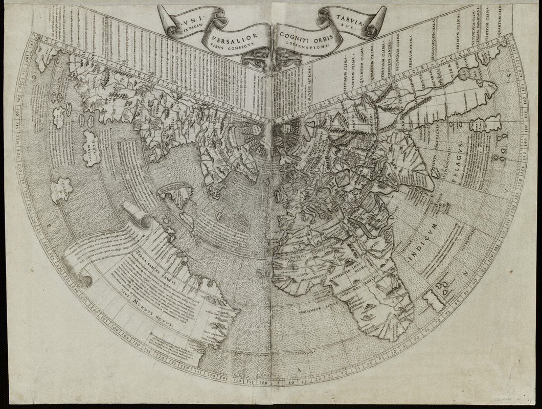
Uniuersalior cogniti orbis tabula ex recentibus confecta obseruationibus
Item Information
- Title:
- Uniuersalior cogniti orbis tabula ex recentibus confecta obseruationibus
- Title (alt.):
-
Universalior cogniti orbis tabula ex recentibus confecta observationibus
Vniversalior cogniti orbis tabvla ex recentibvs confecta observationibvs
- Description:
-
In 1507, the same year that Martin Waldseemüller issued three works announcing the existence of a new continent which he named America, Johann Ruysch published a totally different world map. This rendition, which supports Columbus' hypothesis that his discoveries were islands off the coast of the Asian mainland, suggests the difficulty European cartographers were having in trying to understand accounts of the exploration of New World discoveries. On this map, Greenland (Gruenlant) and Newfoundland (Terra Nova), reflecting John Cabot's discoveries as well as English and Portuguese fishing interests in the area, are attached to the Asian mainland. Hispaniola (Spagnola) and the other Caribbean islands, based on Columbus' and later Spanish discoveries, are depicted as islands near the Asian mainland while the northern coast of South America is depicted as an amorphous landmass floating in the middle of the ocean. Ruysch applied the name "Mundus Novus" to these new lands. Ruysch, a native of Antwerp who lived in Germany, was a skilled cartographer. His map was included in the Rome edition of Ptolemy's Geographia published in 1507. It was the first edition of Geographia to include a world map incorporating the New World discoveries. The map apparently relied heavily on Portuguese sources, since it was also the first map to accurately portray the Portuguese discoveries in southern Asia. It modified the shapes of India and Ceylon as they appeared on earlier Ptolemaic maps.
- Creator:
- Ruysch, Johannes, d. 1533
- Date:
-
1507
- Format:
-
Maps/Atlases
- Location:
- Private Collection
- Collection (local):
-
Mapping Boston Collection
- Subjects:
-
World maps--Early works to 1800
- Places:
-
World
- Extent:
- 1 map ; 41 x 54 cm.
- Terms of Use:
-
No known copyright restrictions.
This work is licensed for use under a Creative Commons Attribution Non-Commercial Share Alike License (CC BY-NC-SA).

- Publisher:
-
Romeo :
Bernardinus Venetus de Vitalibus
- Scale:
-
Scale not given
- Language:
-
Latin
- Notes:
-
Relief shown pictorially.
Appears in Ptolemy's Geographica. Rome. 1507.
Exhibited in “Journeys of the Imagination,” at the Boston Public Library, Boston, MA, April - August 2006.
- Identifier:
-
05_01_000211
- Barcode:
-
39999052509344


![Hemispheriu[m] ab aequinoctiali linea, ad circulu[m] Poli Arctici](https://bpldcassets.blob.core.windows.net/derivatives/images/commonwealth:3f462s45p/image_thumbnail_300.jpg)

