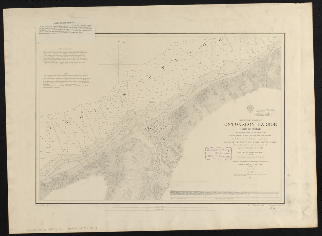
Preliminary chart of Ontonagon Harbor, Lake Superior : from surveys under the direction of the Topographical Bureau of the War Department in obedience to acts of Congress requiring the Survey of the north and north western lakes
Item Information
- Title:
- Preliminary chart of Ontonagon Harbor, Lake Superior : from surveys under the direction of the Topographical Bureau of the War Department in obedience to acts of Congress requiring the Survey of the north and north western lakes
- Issuing body:
- U.S. Lake Survey
- Draftsman:
- Raynolds, W. F. (William Franklin), 1820-1894
- Surveyor:
- Raynolds, W. F. (William Franklin), 1820-1894
- Surveyor:
- Henry, D. F. (Daniel Farrand), 1833-1907
- Surveyor:
- Macomb, J. N. (John N.), 1810 or 1811-1889
- Illustrator:
- Mueller, J. U.
- Surveyor:
- Mueller, J. U.
- Surveyor:
- Wallace, J.
- Draftsman:
- Barney, Joshua, 1799 or 1800-1867
- Contributor:
- United States. Topographical Bureau
- Engraver:
- Dougal, William H., 1822-1895
- Publishing director:
- Meade, George Gordon, 1815-1872
- Name on Item:
-
surveyed and drawn under the direction of Captain J.N. Macomb, Topl. Engrs. by Lieut. W.P. Raynolds, Topl. Engrs. ; assisted by J.U. Mueller, D.F. Henry and J. Wallace ; reduced for publication under the direction of Captain G.G. Meade, Topl. Engrs, 1859 ; drawn for engraving by Joshua Barney ; engraved by W.H. Dougal
- Date:
-
1880
- Format:
-
Maps/Atlases
- Location:
-
Boston Public Library
Norman B. Leventhal Map & Education Center - Collection (local):
-
Norman B. Leventhal Map & Education Center Collection
- Subjects:
-
Harbors--Michigan--Ontonagon--Maps
Nautical charts--Michigan--Ontonagon
Nautical charts--Superior, Lake
Ontonagon (Mich.)--Maps
- Places:
-
MichiganOntonagon (county)Ontonagon
- Extent:
- 1 map ; 35 x 52 cm
- Terms of Use:
-
No known copyright restrictions.
No known restrictions on use.
- Publisher:
-
[Washington, D.C.] :
[U.S. Lake Survey]
- Scale:
-
Scale 1:16,000
- Language:
-
English
- Notes:
-
Relief shown by hachures. Depths shown by soundings and isolines.
Includes sailing directions, note and view of Ontonagon Harbor / drawn by J. Mueller, C.E. 1855.
"Harbor-piers and sanding between and outside of ends of piers added in 1880."
Note issued 1894 tipped-on in upper left.
- Identifier:
-
06_01_015601
- Call #:
-
G4114.O5P5 1880 .U83
- Barcode:
-
39999085938049


