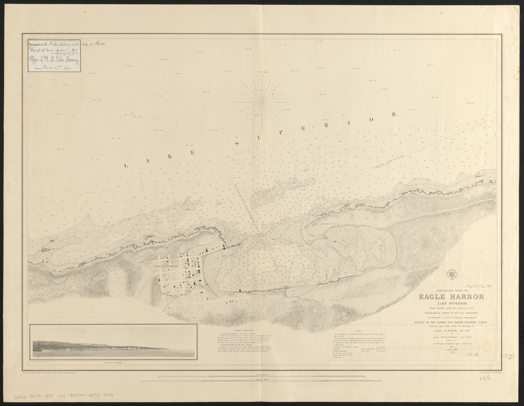
Preliminary chart of Eagle Harbor, Lake Superior : from surveys under the direction of the Topographical Bureau of the War Department, in obedience to acts of Congress requiring the Survey of the north and north western lakes
Item Information
- Title:
- Preliminary chart of Eagle Harbor, Lake Superior : from surveys under the direction of the Topographical Bureau of the War Department, in obedience to acts of Congress requiring the Survey of the north and north western lakes
- Title (alt.):
-
Eagle Harbor, Lake Superior
- Issuing body:
- U.S. Lake Survey
- Surveyor:
- Raynolds, W. F. (William Franklin), 1820-1894
- Surveyor:
- Macomb, J. N. (John N.), 1810 or 1811-1889
- Illustrator:
- Mueller, J. U.
- Surveyor:
- Mueller, J. U.
- Surveyor:
- Henry, D. F. (Daniel Farrand), 1833-1907
- Surveyor:
- Wallace, J.
- Draftsman:
- Poe, O. M. (Orlando Metcalfe), 1832-1895
- Draftsman:
- Gillman, Henry, 1833-1915
- Contributor:
- United States. Topographical Bureau
- Engraver:
- Dougal, William H., 1822-1895
- Name on Item:
-
surveyed and drawn under the direction of Captain J.M. Macomb Topl. Engrs. by Lieut. W.F. Raynolds Topl. Engrs. ; assisted by J.U. Mueller, D.F. Henry, & J. Wallace, 1855 ; drawn for engraving by Lt. O.M. Poe, Topl. Engrs. and H. Gillman ; engraved by W.H. Dougal
- Date:
-
1858
- Format:
-
Maps/Atlases
- Location:
-
Boston Public Library
Norman B. Leventhal Map & Education Center - Collection (local):
-
Norman B. Leventhal Map & Education Center Collection
- Subjects:
-
Nautical charts--Michigan--Eagle Harbor (Bay)
Nautical charts--Superior, Lake
Eagle Harbor (Mich.)--Maps
Eagle Harbor (Mich. : Bay)--Maps
- Places:
-
MichiganKeweenaw (county)Eagle Harbor (bay)
MichiganKeweenaw (county)Eagle Harbor
- Extent:
- 1 map ; 49 x 73 cm
- Terms of Use:
-
No known copyright restrictions.
No known restrictions on use.
- Publisher:
-
[Washington, D.C.] :
[U.S. Lake Survey]
- Scale:
-
Scale 1:5,000
- Language:
-
English
- Notes:
-
Relief shown by hachures. Depths shown by soundings and isolines.
Includes sailing directions, note and sketch of the shoreline of Eagle Harbor by J.U. Mueller.
Seal with "Survey of the lakes 1858" at head of title.
Inset: Eagle Harbor / drawn by J.U. Mueller, C.R.
Variant of: Karpinski, C.L. Bib. of the printed maps of Michigan, 841.
- Identifier:
-
06_01_015607
- Call #:
-
G4112.E2P5 1858 .U83
- Barcode:
-
39999085937843


