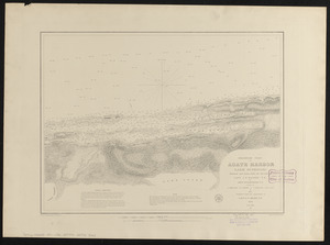
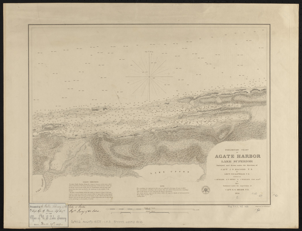
Preliminary chart of Agate Harbor, Lake Superior
Item Information
- Title:
- Preliminary chart of Agate Harbor, Lake Superior
- Title (alt.):
-
Agate Harbor, Lake Superior
- Issuing body:
- U.S. Lake Survey
- Draftsman:
- Raynolds, W. F. (William Franklin), 1820-1894
- Surveyor:
- Raynolds, W. F. (William Franklin), 1820-1894
- Surveyor:
- Macomb, J. N. (John N.), 1810 or 1811-1889
- Surveyor:
- Mueller, J. U. (John U.)
- Surveyor:
- Henry, D. F. (Daniel Farrand), 1833-1907
- Surveyor:
- Wallace, J.
- Draftsman:
- Rabaut, C. P.
- Publishing director:
- Meade, George Gordon, 1815-1872
- Engraver:
- Dougal, William H., 1822-1895
- Name on Item:
-
surveyed and drawn under the direction of Capt. J.N. Macomb T.E. by Lieut. W.F. Raynolds T.E., assisted by J. Mueller, D.F. Henry, & J. Wallace, Civil Assists. in 1855 ; drawn for engraving by C.P. Rabaut ; engraved by W.H. Dougal
- Date:
-
1858
- Format:
-
Maps/Atlases
- Location:
-
Boston Public Library
Norman B. Leventhal Map & Education Center - Collection (local):
-
Norman B. Leventhal Map & Education Center Collection
- Subjects:
-
Nautical charts--Michigan--Agate Harbor
Agate Harbor (Mich.)--Maps
Superior, Lake--Maps
- Places:
-
MichiganKeweenaw (county)Agate Harbor (bay)
- Extent:
- 1 map ; 36 x 49 cm
- Terms of Use:
-
No known copyright restrictions.
No known restrictions on use.
- Publisher:
-
[Washington, D.C.] :
[U.S. Lake Survey]
- Scale:
-
Scale approximately 1:10,000
- Language:
-
English
- Notes:
-
Relief shown by hachures. Depths shown by soundings in feet.
Includes sailing directions and note.
On label pasted in lower left corner: Presented to Library of the Ills. End'l University, Detroit, Feb. 18, 1918, C.B. Comstock, Survey N. & N.W. Lakes.
- Identifier:
-
06_01_015598
- Call #:
-
G4112.A22P5 1858 .U83
- Barcode:
-
39999085938015