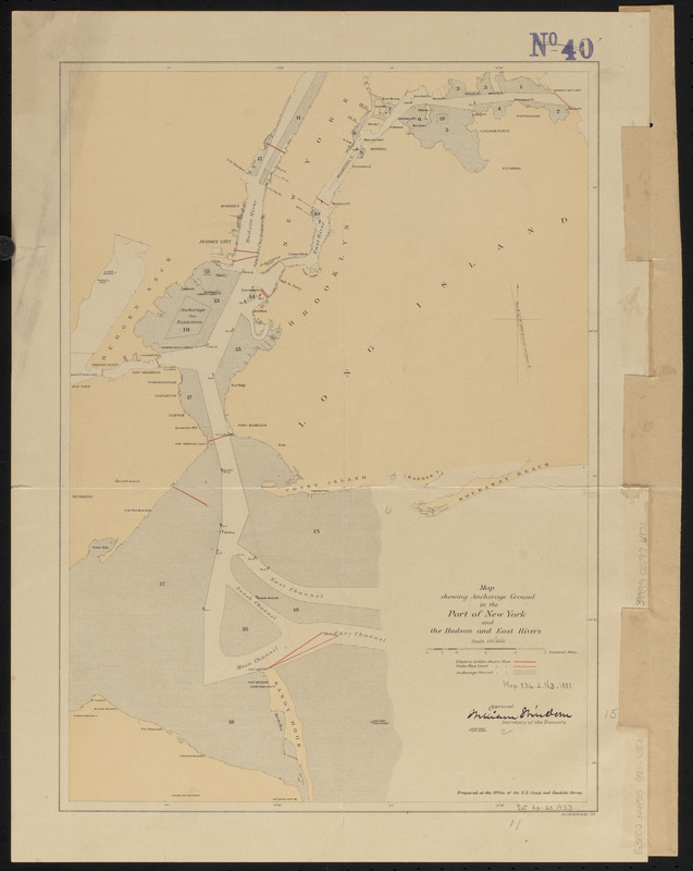
Map showing anchorage ground in the Port of New York and the Hudson and East Rivers
Item Information
- Title:
- Map showing anchorage ground in the Port of New York and the Hudson and East Rivers
- Cartographer:
- U.S. Coast and Geodetic Survey
- Lithographer:
- Julius Bien & Co.
- Name on Item:
-
prepared at the Office of the U.S. Coast and Geodetic Survey ; approved William Windom, Secretary of the Treasury
- Date:
-
1881
- Format:
-
Maps/Atlases
- Location:
-
Boston Public Library
Norman B. Leventhal Map & Education Center - Collection (local):
-
Norman B. Leventhal Map & Education Center Collection
- Subjects:
-
Anchorage--New York Harbor (N.Y. and N.J.)--Maps
New York Harbor (N.Y. and N.J.)--Maps
- Places:
-
New YorkNew York
- Extent:
- 1 map : color ; 40 x 28 cm
- Terms of Use:
-
No known copyright restrictions.
No known restrictions on use.
- Publisher:
-
[Washington, D.C.] ; [New York] :
[U.S. Coast and Geodetic Survey] ; Julius Bien & Co. lith.
- Scale:
-
Scale 1:120,000
- Language:
-
English
- Notes:
-
Shows electrical cables, water pipe lines and anchorage ground.
- Identifier:
-
06_01_015480
- Call #:
-
G3802.N4P55 1881 .U83
- Barcode:
-
39999085936951