Lloyd's new political chart, 1861 : with a map of the United States, showing the free states, border slave states, cotton states, and territories, in different colors
Item Information
- Title:
- Lloyd's new political chart, 1861 : with a map of the United States, showing the free states, border slave states, cotton states, and territories, in different colors
- Title (alt.):
-
National political chart
- Description:
-
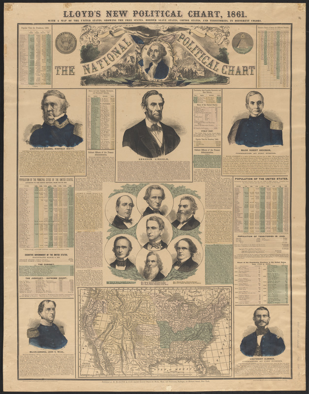
Compiled and published by H.H. Lloyd & Co. Hand-colored lithograph composed of map, wood-cut portraits, biographies and statistics. Includes portraits of political figures and biographies of Lincoln and his cabinet Lieutenant-General Winfield Scott, Major Robert Anderson, Major-General John Wool and Lieutenant Slemmer (commanding Fort Pickens). The statistics include census information for major cities, electoral results for every election from 1796 and popular vote data by state for the election of 1860.
- Publisher:
- H.H. Lloyd & Co.
- Engraver:
- Orr, John William, 1815-1887
- Date:
-
1861
- Format:
-
Maps/Atlases
Posters
- Location:
-
Boston Public Library
Norman B. Leventhal Map & Education Center - Collection (local):
-
Norman B. Leventhal Map & Education Center Collection
- Subjects:
-
Cabinet officers--United States--19th century--Pictorial works
Presidents--United States--Election--19th century--Statistics
United States--History--1783-1865--Maps
United States--Politics and government--1861-1865
Lincoln, Abraham, 1809-1865
- Places:
-
United States
- Extent:
- 1 broadside : illustration, map, portraits, charts ; 93 x 73 cm
- Terms of Use:
-
No known copyright restrictions.
No known restrictions on use.
- Publisher:
-
New York :
H.H. Lloyd & Co.
- Scale:
-
Scale approximately 1:3,250,000
- Language:
-
English
- Identifier:
-
06_01_016057
- Call #:
-
E456 .H55 1861
- Barcode:
-
39999085941498