Toggle navigation
LMEC Home
Exhibitions
Georeferencing
Tools for Teachers
Collections
My Favorites
Sign Up / Log In
Search
Search the map portal
Map Collection
Map Collection
Map Sets
Search
Search
Search for
Search In
All Fields
Creator
Title
Subject
Place
Search All Digital Collections
Advanced Search
198 Results
My Search
Start Over
1877
Remove constraint 1877
Filter your Search
Place
North and Central America
94
United States
72
Oceania
37
Massachusetts
29
Europe
27
South America
21
Asia
15
Chile
14
more
Place
»
Topic
United States Exploring Expedition (1838-1842)
16
Canada--Boundaries--United States--Maps
13
United States--Boundaries--Canada--Maps
13
United States--History--War of 1812--Territorial questions--Maps
13
Balkan Peninsula--Maps
7
Tuamotu Archipelago (French Polynesia)--Maps
7
Turkey--Maps
7
Coasts--Chile--Maps
4
more
Topic
»
Date
Date range begin
–
Date range end
Current results range from
1755
to
1952
View distribution
Creator
United States. Hydrographic Office
42
Wilkes, Charles, 1798-1877
38
United States Exploring Expedition (1838-1842)
35
Sherman & Smith
21
Barclay, Anthony, 1792-1877
13
Porter, Peter B. (Peter Buell), 1773-1844
13
United States. Light-House Board
13
Thompson, David, 1770-1857
11
more
Creator
»
Format
Maps/Atlases
197
Manuscripts
1
Photographs
1
Georeferenced
Yes
10
No
188
Collection
Norman B. Leventhal Map & Education Center Collection
187
Maritime Charts and Atlases
81
Boston and New England Maps
42
Urban Maps
42
American Antiquarian Society Collection
4
American Revolutionary War-Era Maps
4
Town plans, 1830
4
American Textile History Museum Image Collection
2
more
Collection
»
Available to use
No known restrictions
188
Creative Commons license
2
Search Constraints
Sort by relevance
relevance
title
date (asc)
date (desc)
Number of results to display per page
50 per page
10
per page
20
per page
50
per page
100
per page
View results as:
grid view
map view
Search Results
1.
Russisch-Türkischer Kriegsschauplatz, 1877
2.
Map of Boston, for 1877
3.
Serio-comic war map for the year 1877
4.
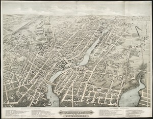
Bird's eye view of Pawtucket & Central Falls, R.I. 1877
5.
Dedication of the Army and Navy Monument, Sept. 17, 1877
6.
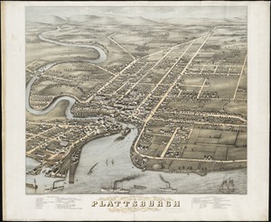
Bird's eye view of Plattsburgh, Clinton Co., New York 1877
7.
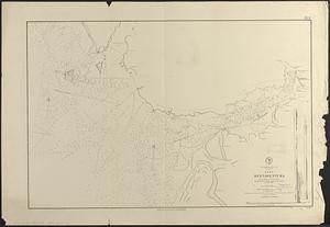
Bird's eye view of Rochester, Strafford County, New Hampshire, 1877 : from a position, east of town
8.
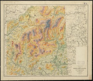
Map of the White Mountains of New Hampshire from Walling's map of the state, 1877
9.
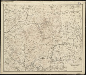
Map of the White Mountains of New Hampshire from Walling's map of the state 1877
10.
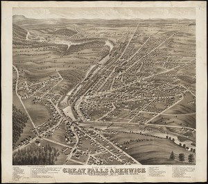
Bird's eye view of Great Falls, Strafford Co., New Hampshire & Berwick, York Co., Maine, 1877 : from position north west,...
11.
Bird's eye view of Bristol, R.I : 1877
12.
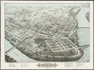
Bird's eye view of Holyoke, Mass : 1877
13.
City of Cambridge, Mass : 1877
14.
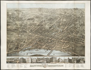
The city of Hartford Connecticut : 1877
15.
Spencer, Mass : 1877
16.
Troy, N.Y : 1877
17.
Turners Falls, Mass : 1877
18.
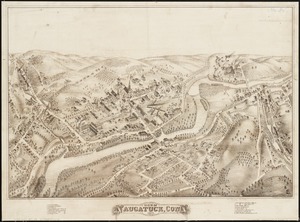
View of Naugatuck, Conn : 1877
19.
View of Peabody, Mass : 1877
20.
View of Putnam, Conn : 1877
21.
View of Rockville, Conn : 1877
22.
View of Warren, R.I : 1877
23.
View of Westerly, R.I : 1877
24.
View of Winsted, Conn : 1877
25.
City of Fall River, Mass : 1877
26.
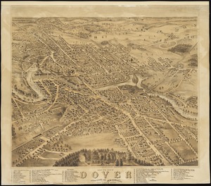
Bird's eye view of Dover, Strafford Co., New Hampshire : 1877, looking southwest
27.
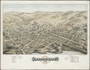
View of Natick, Mass : 1877, population about 8000
28.
China Sea, Hongkong, Man of War Anchorage : from a British survey in 1877
29.
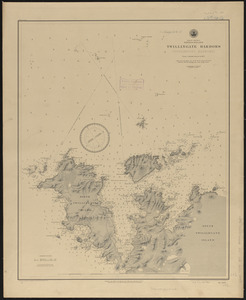
North America, Newfoundland, Twillingate Harbors (Toulinguet Harbors) : from a British survey in 1877
30.
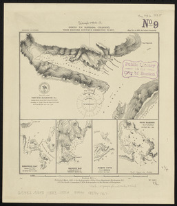
Ports in Barbara Channel : from British surveys corrected to 1877
31.
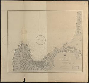
South America, Chili, Valparaiso Bay : from a Chilian survey in 1877
32.
South America, ports in Desolation and Sta. Ines Is. : from British surveys corrected to 1877
33.
South America, ports in the Strait of Magellan : from British surveys corrected to 1877
34.
South America, ports on the south side of Tierra del Fuego : from British surveys corrected to 1877
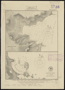
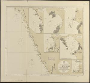
35.
South America, Tierra del Fuego : from British surveys corrected to 1877
36.
South extreme of America, Hermite Island, St. Martin Cove : from British surveys corrected to 1877
37.
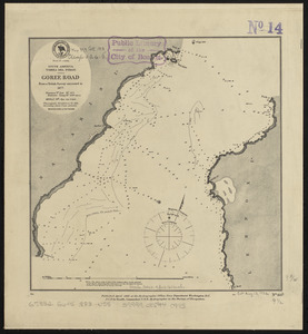
South America, Tierra del Fuego, Goree Road : from a British survey corrected to 1877
38.
South America, Tierra del Fuego, Packsaddle Bay : from a British survey corrected to 1877
39.
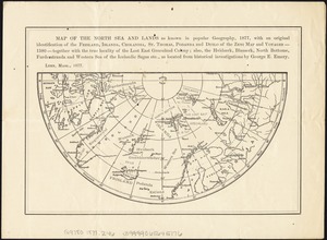
Map of the North Sea and lands as known in popular geography, 1877, with an original identification of the Frisland, Islanda,...
40.
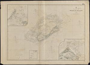
North Atlantic Ocean, Bermuda Islands : from the most recent Brit. Admty. surveys, 1877
41.
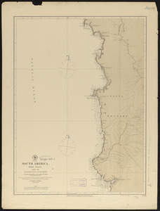
South America, west coast : republication of Brit. Admty. chart no. 1285, with additions to 1877
42.
South America, west coast, sheet 19, Buenaventura to Cape Marzo : republication of Brit. Admty. chart no. 2258, with additions...
43.
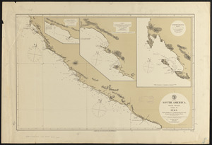
South America, west coast, sheet XII, Peru, Pescadores Pt. to Independencia Bay : republication of Brit. Admty. chart no. 1279,...
44.
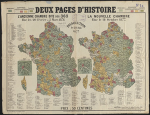
Deux pages d'histoire : l'ancienne Chambre dite des 363, elue les 20 Février et 5 Mars 1876, dissolution le 23 Juin 1877, la...
45.
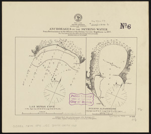
South America, Magellan Strait, anchorages in the Skyring Water : from a reconnaissance by the officers of the Chilean corvette...
46.
South America, west coast, Nueva Granada, Port Buenaventura : from a British survey in 1846 ; republication of Brit. Admty....
47.
West Indies, island of Haïti, Cape Haïti Harbor (Cape Guarico of the Spaniards) : from a British survey in 1840 :...
48.
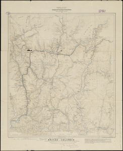
Map of a portion of the southern Interior of British Columbia : embodying the explorations made in 1877 by G.M. Dawson, and in...
49.
South America, west coast, harbors on the coast of Ecuador : from British surveys in 1837 and 1847 ; republication of Brit....
50.
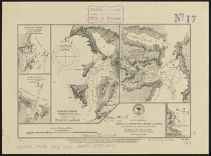
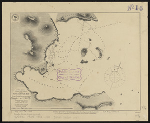
City of Boston improved sewerage : plan showing region drained by, and lines of proposed intercepting sewer, also course of...
‹ Prev
Next ›
1
2
3
4