Toggle navigation
LMEC Home
Exhibitions
Georeferencing
Tools for Teachers
Collections
My Favorites
Sign Up / Log In
Search
Search the map portal
Map Collection
Map Collection
Map Sets
Search
Search
Search for
Search In
All Fields
Creator
Title
Subject
Place
Search All Digital Collections
Advanced Search
30 Results
My Search
Start Over
east africa
Remove constraint east africa
Filter your Search
Place
Africa
18
World
6
Europe
5
North Africa
4
Asia
3
Lindi Region
3
Middle East
3
Madagascar
2
more
Place
»
Topic
World maps--Early works to 1800
6
Chronology, Historical--Maps--Early works to 1800
2
Coasts--Madagascar--Maps
2
Eastern Hemisphere--Maps--Early works to 1800
2
Madagascar--Maps
2
Nautical charts--Madagascar
2
Saint Helena--Maps--Early works to 1800
2
1732
1
more
Topic
»
Date
Date range begin
–
Date range end
Current results range from
1483
to
1943
View distribution
Creator
United States. Hydrographic Office
6
Moll, Herman, d. 1732
3
Schedel, Hartmann, 1440-1514
2
Wolgemut, Michael, 1434-1519
2
Bellin, Jacques Nicolas, 1703-1772
1
Bowen, Emanuel, d. 1767
1
Bowles, John, 1701-1779
1
Bowles, Thomas, 1694-1773
1
more
Creator
»
Format
Maps/Atlases
30
Georeferenced
Yes
4
No
26
Collection
Norman B. Leventhal Map Center Collection
25
Maritime Charts and Atlases
7
Mapping Boston Collection
4
American Revolutionary War-Era Maps
1
MacLean Collection Map Library
1
Map Collections at Phillips Academy
1
Ralph Finos Map Collection at Phillips Academy
1
Sidney R. Knafel Map Collection at Phillips Academy
1
more
Collection
»
Available to use
No known restrictions
23
Creative Commons license
4
Search Constraints
Sort by relevance
relevance
title
date (asc)
date (desc)
Number of results to display per page
20 per page
10
per page
20
per page
50
per page
100
per page
View results as:
grid view
map view
Search Results
1.
Africa, east coast, Brava Harbor
2.
Africa--east coast, coast of Zanzibar, Kiswere Harbor : from a British survey by the officers of H.M.S. Nassau, 1874 :...
3.
Africa--east coast, harbors on the coast of Zanzibar : from a British survey by the officers of H.M.S. Nassau, 1874 :...
4.
Africa--east coast, coast of Zanzibar, Mchinga Bay (Port Nungwa) : from a British survey by the officers of H.M.S. Nassau, 1874...
5.
Africa--east coast, coast of Zanzibar, Mikindani Bay with Mto Mtwara and Mikindani Harbrs : from a British survey by the...
6.
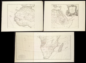
Europe, Africa and the Far East
7.
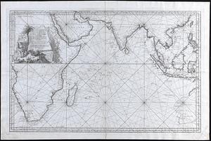
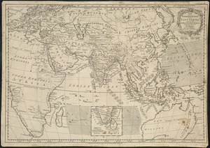
Carte reduite de l Ocean Oriental ou Mer des Indes
8.
Karte Von Africa
9.
Standard railway map of South Africa = Standaard spoorwegkaart van Suidafrika
10.
Map of the European settlements in the East Indies and on the eastern coast of Africa including part of Europe
11.
Plan of the bay of Saldanha on the S.W. coast of Africa shewing the opperations [sic] of the squadron of Commodore Johnstone,...
12.
The Turkish Empire in Europe, Asia and Africa, dividid into all its governments, together with the other territories that are...
13.
The west part of Barbary containing Fez, Marocco, Algiers and Tunis / : The east part of Barbary containing Tripoli, Barca and...
14.
Indian Ocean : ports on the east coast of Madagascar : from British and French surveys, corrected to 1874
15.
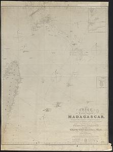
Chart of the east coast of Madagascar, including the Mauritius, Seychelle islands &c. between the latitudes of 2°30' & 26°30'...
16.
St. Helena : this island belongs to ye English east India Company whose ships usually touch here for a recruit of fresh water...
17.
An historical map of the Roman Empire and the neighbouring barbarous nations to the year of our Lord four hundred when the...
18.
Tabulae maximae quibus illustrantur terrae veterum in usum scholarum
19.
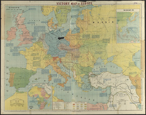
The victory war map
20.
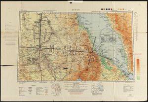
Sudan
‹ Prev
Next ›
1
2


![Plan of the bay of Saldanha on the S.W. coast of Africa shewing the opperations [sic] of the squadron of Commodore Johnstone, in the attack upon the five Dutch East India ships on the morning of July 21st: AD: 1781](https://bpldcassets.blob.core.windows.net/derivatives/metadata/commonwealth-oai:7d27dp94q/image_thumbnail_300.jpg)