Toggle navigation
LMEC Home
Exhibitions
Georeferencing
Tools for Teachers
Collections
My Favorites
Sign Up / Log In
Search
Search the map portal
Map Collection
Map Collection
Map Sets
Search
Search
Search for
Search In
All Fields
Creator
Title
Subject
Place
Search All Digital Collections
Advanced Search
9 Results
My Search
Start Over
Croatia
Remove constraint Croatia
Filter your Search
Place
Europe
8
Austria
2
Croatia
2
Istra
2
Slovenia
2
Switzerland
2
Venetan
2
Balkan Peninsula
1
more
Place
»
Topic
Austria--Maps--Early works to 1800
2
Croatia--Maps--Early works to 1800
2
Istria (Croatia and Slovenia)--Maps--Early works to 1800
2
Slovenia--Maps--Early works to 1800
2
Switzerland--Maps--Early works to 1800
2
Veneto (Italy)--Maps--Early works to 1800
2
Balkan Peninsula--Maps--Early works to 1800
1
Bosnia and Herzegovina--Maps
1
more
Topic
»
Date
Date range begin
–
Date range end
Current results range from
1482
to
1922
View distribution
Creator
Cassini, Gio. Ma. (Giovanni Maria), 1745-ca. 1824
2
Ptolemy, 2nd cent
2
American Geographical Society of New York
1
Delarochette, L. (Louis), 1731-1802
1
Deroko, Dragutin J.
1
Geographisches Institut (Weimar, Thuringia, Germany)
1
Hol, Lienhart
1
Kiepert, Heinrich, 1818-1899
1
more
Creator
»
Format
Maps/Atlases
9
Georeferenced
No
9
Collection
Norman B. Leventhal Map Center Collection
9
Available to use
No known restrictions
9
Search Constraints
Sort by relevance
relevance
title
date (asc)
date (desc)
Number of results to display per page
20 per page
10
per page
20
per page
50
per page
100
per page
View results as:
grid view
map view
Search Results
1.
Regni Hungariae, et regionum, quae ei quondam fuêre unitae, ut Transilvaniae, Valachiae, Moldaviae, Serviae, Romaniae,...
2.
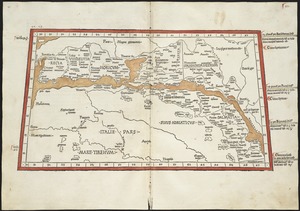
Quinta Europe tabula continet Rhetia
3.
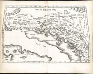
Tabula V Europae
4.
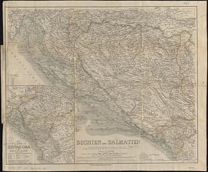
Bosnien und Dalmatien : vorzüglich nach österreichischen aufnahmen, mit benutzung von a Boués reisen (Montenegro nach...
5.
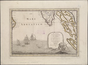
Lo Stato Veneto da terra diviso nelle sue provincie : quarta parte che compren de porzioni del Dogado e dell' Istria
6.
Lo Stato Veneto da terra diviso nelle sue provincie : seconda parte che comprede porzioni del Dogado del Trevisano del Friuli e...
7.
Map of the Empire of Germany : including all the states comprehended under that name : with the Kingdom of Prussia, &c
8.
Block diagram showing terrain of the Trieste-Isonzo region
9.
Železnička i brodarska karta Kraljevine Srba Hrvata i Slovenaca = Carte des chemins de fer et de naviation du Royaume des...
![Regni Hungariae, et regionum, quae ei quondam fuêre unitae, ut Transilvaniae, Valachiae, Moldaviae, Serviae, Romaniae, Bulgariae, Bessarabiae, Croatiae, Bosniae, Dalmatiae, Sclavoniae, Morlachiae, Ragusanae Reipublicae, maximaeq[ue] partis Danubii Fluminis, novissima delineatio](https://bpldcassets.blob.core.windows.net/derivatives/images/commonwealth:cj82ks70z/image_thumbnail_300.jpg)