Toggle navigation
LMEC Home
Exhibitions
Georeferencing
Tools for Teachers
Collections
My Favorites
Sign Up / Log In
Search
Search the map portal
Map Collection
Map Collection
Map Sets
Search
Search
Search for
Search In
All Fields
Creator
Title
Subject
Place
Search All Digital Collections
Advanced Search
2 Results
My Search
Start Over
saba
Remove constraint saba
Filter your Search
Place
Anguilla
2
Guadeloupe
2
Leeward Islands
2
North and Central America
2
Saint Kitts and Nevis
2
Saint-Barthélemy
2
Saint-Martin-Saint-Barthélemy
2
Netherlands Antilles
1
more
Place
»
Topic
Anguilla--Maps
1
Anguilla--Maps--Early works to 1800
1
Leeward Islands (West Indies)--Maps
1
Leeward Islands (West Indies)--Maps--Early works to 1800
1
Nevis--Maps--Early works to 1800
1
Saint Barthélemy--Maps
1
Saint Kitts and Nevis--Maps
1
Saint Kitts--Maps--Early works to 1800
1
more
Topic
»
Date
1781
2
Creator
Bew, John, -1793
1
Lodge, John, -1796
1
Format
Maps/Atlases
2
Georeferenced
No
2
Collection
American Revolutionary War-Era Maps
2
Norman B. Leventhal Map Center Collection
1
William L. Clements Library Collection
1
Available to use
No known restrictions
1
Search Constraints
Search for
sara
or
saga
or
sala
or
samba
or
sale
instead?
Sort by relevance
relevance
title
date (asc)
date (desc)
Number of results to display per page
20 per page
10
per page
20
per page
50
per page
100
per page
View results as:
grid view
map view
Search Results
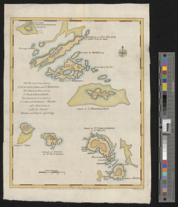
1.
The Dutch islands of St. Eustatia, Saba, and St. Martins ; the French island of St. Bartholomew ; the English islands of St....
2.
The Dutch islands of St. Eustatia, Saba, and St. Martins; the French island of St. Bartholomew; the English islands of St....