Toggle navigation
LMEC Home
Exhibitions
Georeferencing
Tools for Teachers
Collections
My Favorites
Sign Up / Log In
Search
Search the map portal
Map Collection
Map Collection
Map Sets
Search
Search
Search for
Search In
All Fields
Creator
Title
Subject
Place
Search All Digital Collections
Advanced Search
2 Results
My Search
Start Over
niger
Remove constraint niger
Filter your Search
Place
Africa
1
Nile River
1
West Africa
1
Topic
Africa, West--Maps--Early works to 1800
1
Africa--Maps
1
Nile River--Maps
1
Date
Date range begin
–
Date range end
Current results range from
1732
to
1898
View distribution
Creator
Bowles, John, 1701-1779
1
Bowles, Thomas, 1694-1773
1
Moll, Herman, d. 1732
1
W. & A.K. Johnston Limited
1
Format
Maps/Atlases
2
Georeferenced
No
2
Collection
Norman B. Leventhal Map Center Collection
2
Available to use
No known restrictions
2
Search Constraints
Search for
nigger
or
nigel
or
night
or
never
or
nigeria
instead?
Sort by relevance
relevance
title
date (asc)
date (desc)
Number of results to display per page
20 per page
10
per page
20
per page
50
per page
100
per page
View results as:
grid view
map view
Search Results
1.
W. & A.K. Johnston's maps to illustrate the Niger and Upper Nile questions
2.
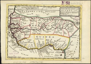
Negroland and Guinea : with the European settlements explaining what belongs to England, Holland, Denmark &c