Toggle navigation
LMEC Home
Exhibitions
Georeferencing
Tools for Teachers
Collections
My Favorites
Sign Up / Log In
Search
Search the map portal
Map Collection
Map Collection
Map Sets
Search
Search
Search for
Search In
All Fields
Creator
Title
Subject
Place
Search All Digital Collections
Advanced Search
3 Results
My Search
Start Over
mauritius
Remove constraint mauritius
Filter your Search
Place
Mauritius
2
Africa
1
Asia
1
Australasia
1
Indian Ocean
1
Madagascar
1
Oceania
1
Pacific Ocean
1
more
Place
»
Topic
Asia--Maps
1
Australasia--Maps
1
Coasts--Madagascar--Maps
1
Indian Ocean--Maps
1
Madagascar--Maps
1
Mauritius--Maps
1
Mauritius--Maps--Early works to 1800
1
Nautical charts--Asia
1
more
Topic
»
Date
Date range begin
–
Date range end
Current results range from
1781
to
1867
View distribution
Creator
Great Britain. Hydrographic Office
1
Hobbs, J. S. (John Stratton)
1
J. & C. Walker (Firm)
1
Lodge, John, d. 1796
1
Owen, W. F. W., 1774-1857
1
Vidal, A. T. E. (Alexander Thomas Emeric), 1792-1863
1
Wilson, Charles, active 1888
1
Format
Maps/Atlases
3
Georeferenced
No
3
Collection
Norman B. Leventhal Map Center Collection
3
Maritime Charts and Atlases
2
Available to use
No known restrictions
3
Search Constraints
Search for
maritimus
or
maurits
instead?
Sort by relevance
relevance
title
date (asc)
date (desc)
Number of results to display per page
20 per page
10
per page
20
per page
50
per page
100
per page
View results as:
grid view
map view
Search Results
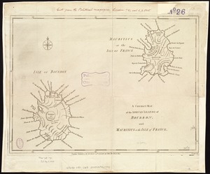
1.
A correct map of the African islands of Bourbon, and Mauritius or the Isle of France
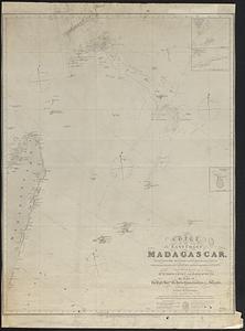
2.
Chart of the east coast of Madagascar, including the Mauritius, Seychelle islands &c. between the latitudes of 2°30' & 26°30'...
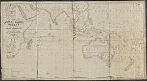
3.
A general chart of the Indian and part of the Pacific Oceans, shewing the various passages to & from China, Australia, New...