Toggle navigation
LMEC Home
Exhibitions
Georeferencing
Tools for Teachers
Collections
My Favorites
Sign Up / Log In
Search
Search the map portal
Map Collection
Map Collection
Map Sets
Search
Search
Search for
Search In
All Fields
Creator
Title
Subject
Place
Search All Digital Collections
Advanced Search
30 Results
My Search
Start Over
framingham
Remove constraint framingham
Filter your Search
Place
North and Central America
30
United States
29
Boston
12
Middlesex (county)
12
Suffolk (county)
12
Framingham
10
Massachusetts
3
Worcester (county)
3
more
Place
»
Topic
Boston (Mass.)--Maps
12
Bus rapid transit--Massachusetts--Boston--Maps
11
Local transit--Massachusetts--Boston--Maps
11
Massachusetts Bay Transportation Authority
11
Subways--Massachusetts--Boston--Maps
11
Framingham (Mass.)--Aerial views
5
Framingham (Mass.)--Maps
2
Real property--Massachusetts--Framingham--Maps
2
more
Topic
»
Date
Date range begin
–
Date range end
Current results range from
1794
to
1993
View distribution
Creator
Massachusetts Bay Transportation Authority
11
General Drafting Company
8
Bigelow, E. H.
4
Cities, inc.
3
Geo. H. Walker & Co.
2
Poole, A. F.
2
A.F. Poole & Co.
1
Applied Geographics, Inc.
1
more
Creator
»
Format
Maps/Atlases
29
Books
1
Prints
1
Georeferenced
Yes
1
No
29
Collection
Norman B. Leventhal Map Center Collection
28
Boston and New England Maps
15
Urban Maps
12
Applied Geographics, Inc. Records
1
Town plans, 1794
1
Town plans, 1830
1
Available to use
No known restrictions
30
Search Constraints
Sort by relevance
relevance
title
date (asc)
date (desc)
Number of results to display per page
20 per page
10
per page
20
per page
50
per page
100
per page
View results as:
grid view
map view
Search Results
1.
Camp at Framingham : First Brigade Mass. Vol. Militia June 9th to 13th 1885
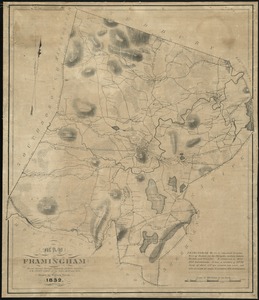
2.
Map of Framingham : from actual surveys taken by Jonas Clayes & Warren Nixon in the years 1830 and 1831
3.
Camp at Framingham : Second Brigade Mass. Vol. Militia, July 21st to 25th 1885
4.
South Framingham, Massachusetts
5.
South Framingham, Massachusetts : 1882
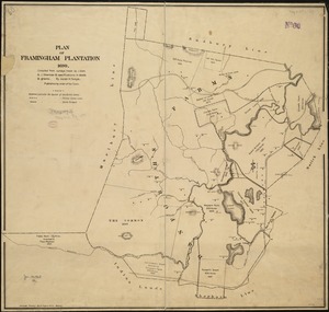
6.
Plan of Framingham Plantation 1699
7.
Boston Clinton Fitchburg and Mansfield Framingham Lowell Railroads, and connections
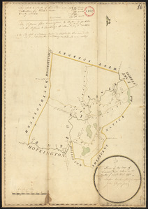
8.
Plan of Framingham, made by Lawson Buckminster, dated December, 1794.
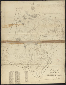
9.
Plan of Framingham made by Jonas Clayes and Warren Nixon, dated 1831
10.
Plan and profiles of surveys from Farm Pond in Framingham and Long Pond in Natick, for supplying water to the City of Boston
11.
Atlas of Middlesex County, Massachusetts, volume 3 : towns of Ashland, Framingham, Holliston, Hopkinton, Natick, Sherborn,...
12.
View of Saxonville, Mass
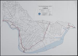
13.
Sewerage division map city of Cambridge
14.
T system map
15.
T system map : 1978-1979
16.
Massachusetts Bay Transportation Authority system map
17.
T 1980 system map
18.
Metropolitan Boston transportation map : subway, bus, rail
19.
Metropolitan Boston transportation map : subway, bus, rail
20.
Metropolitan Boston transportation map : subway, bus, rail
‹ Prev
Next ›
1
2