Toggle navigation
LMEC Home
Exhibitions
Georeferencing
Tools for Teachers
Collections
My Favorites
Sign Up / Log In
Search
Search the map portal
Map Collection
Map Collection
Map Sets
Search
Search
Search for
Search In
All Fields
Creator
Title
Subject
Place
Search All Digital Collections
Advanced Search
83 Results
My Search
Start Over
Russia maps
Remove constraint Russia maps
Filter your Search
Place
Asia
35
Russia
31
North and Central America
18
Europe
15
United States
15
Boston
12
Suffolk (county)
12
Ukraine
7
more
Place
»
Topic
Boston (Mass.)--Maps
12
Immigrants--Massachusetts--Boston--Maps
12
Russia--Maps--Early works to 1800
7
Russia--Maps
6
Europe, Eastern--Maps
5
Europe--Maps
5
Alaska--Maps
4
Ukraine--Maps--Early works to 1800
4
more
Topic
»
Date
Date range begin
–
Date range end
Current results range from
1482
to
2017
View distribution
Creator
United States. Hydrographic Office
10
Boggs, William Brenton, 1809-1875
6
Boston Planning and Development Agency
6
Boston Redevelopment Authority. Office of Digital Cartography & GIS
6
Knorr, E. R. (Ernest Rudolph)
6
United States North Pacific Exploring Expedition (1853-1856)
6
Ptolemy, 2nd cent
5
Siebert, Selmar
5
more
Creator
»
Format
Maps/Atlases
83
Georeferenced
Yes
17
No
66
Collection
Norman B. Leventhal Map Center Collection
80
Maritime Charts and Atlases
10
MacLean Collection Map Library
3
Available to use
No known restrictions
80
Search Constraints
Sort by relevance
relevance
title
date (asc)
date (desc)
Number of results to display per page
20 per page
10
per page
20
per page
50
per page
100
per page
View results as:
grid view
map view
Search Results
1.
Russia
2.
Large scale map of Russia in Europe
3.
A new map of Russia or Moscovie divided into its Kingdoms, Dukedoms, Principalities, Provinces, &c
4.
Russia in Europe
5.
Tabula Russia vulgo Moscovia
6.
To His Most Serene and August Majesty Peter Alexovitz absolute lord of Russia &c. this map of Moscovy, Poland, Little Tartary,...
7.
Carte de da partie européenne de l'empire de Russie : avec l'indication des chemins de poste, ainsi que des douanes...
8.
The Daily Telegraph war map of Siberia (no. 28)
9.
Plan stolichnogo goroda Moskvy i yego okrestnostey s oboznacheniyem basseynov, telegrafnykh stantsiy i soyedinyayushchikh...
10.
The Daily Telegraph war map no. 17
11.
Arctic Ocean, north of Behrings Strait : Wrangel Island, as surveyed by the officers of the U.S.S. Rodgers, Lieut. R.M. Berry...
12.
Siberia
13.
The Russian Empire, in Europe and Asia
14.
Carte de la Russie en Europe : pour servir al'Introduction a l'histoire universelle du Baron de Pufendorf
15.
The Straits of Seniavine, Behring's Straits
16.
The Straits of Seniavine, Behring's Straits
17.
To the Great Czar of Moscovie this Map of Tartary &c. is humbly dedicated
18.
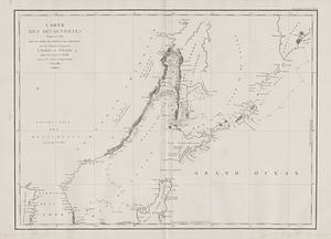
Carte des decouvertes, faites en 1787 dans les mers de Chine et de Tartarie, par les Fregates Francaises la Boussole et...
19.
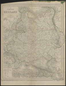
Das Europäische Russland
20.
Alaska and adjoining region
‹ Prev
Next ›
1
2
3
4
5