Toggle navigation
LMEC Home
Exhibitions
Georeferencing
Tools for Teachers
Collections
My Favorites
Sign Up / Log In
Search
Search the map portal
Map Collection
Map Collection
Map Sets
Search
Search
Search for
Search In
All Fields
Creator
Title
Subject
Place
Search All Digital Collections
Advanced Search
16 Results
My Search
Start Over
Antigua and Barbuda
Remove constraint Antigua and Barbuda
Filter your Search
Place
Antigua and Barbuda
16
Antigua
14
North and Central America
8
Barbados
3
Jamaica
3
Cuba
2
United States
2
West Indies
2
more
Place
»
Topic
Antigua--Maps--Early works to 1800
9
Antigua--Maps
5
Barbados--Maps--Early works to 1800
3
Jamaica--Maps--Early works to 1800
3
West Indies--Maps--Early works to 1800
3
Cuba--Maps--Early works to 1800
2
Kingston Harbor (Jamaica)--Maps--Early works to 1800
2
Real property--Antigua and Barbuda--Antigua--Maps
2
more
Topic
»
Date
Date range begin
–
Date range end
Current results range from
1696
to
1889
View distribution
Creator
Buache, Philippe, 1700-1773
2
Jefferys, Thomas, -1771
2
United States. Hydrographic Office
2
Bowen, Emanuel, 1693 or 1694-1767
1
Enthoffer, E. J. (Edward J.)
1
Hazzard, J. L. (John L.)
1
Homann Erben (Firm)
1
Jefferys, Thomas, d. 1771
1
more
Creator
»
Format
Maps/Atlases
16
Georeferenced
Yes
1
No
15
Collection
Norman B. Leventhal Map Center Collection
10
American Revolutionary War-Era Maps
9
Maritime Charts and Atlases
3
Richard H. Brown Revolutionary War Map Collection at Mount Vernon
3
William L. Clements Library Collection
3
Boston and New England Maps
1
Mapping Boston Collection
1
Available to use
No known restrictions
9
Creative Commons license
4
Search Constraints
Sort by relevance
relevance
title
date (asc)
date (desc)
Number of results to display per page
20 per page
10
per page
20
per page
50
per page
100
per page
View results as:
grid view
map view
Search Results
1.
Antigua
2.
West Indies, Antigua, Falmouth and English Harbors : from British surveys corrected to 1872
3.
West Indies, Island of Antigua : from British surveys in 1848 and 1863
4.
A large draft of the island Antegua
5.
Antigue : levée par Robert Baker, Arpenteur General de l'Isle ; traduit de l'Anglais
6.
Antigoa
7.
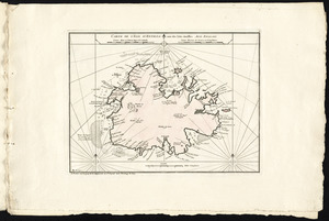
Carte de l'isle d'Antigoa une de Isles Antilles
8.
The island of Antego
9.
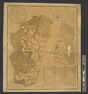
Plan of the estates of Admiral Sr. Jas. Douglas bart. called Douglas & Ravenscroft, and the estate of Robert Harvey esqr....
10.
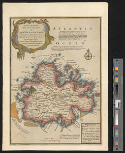
A new and accurate map of the island of Antigua or Antego, taken from surveys and adjusted by astronl. observations, containing...
11.
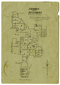
Thibou's and Blizards
12.
Boston Harbour
13.
Dominia anglorum in præcipuis insulis Americæ ut sunt insula : S. Christophori, Antegoa, Iamaica, Barbados : nec non insulae...
14.
The principall islands in America belonging to the English empire viz Iamaica, Barbados, Antegoa, St. Christophers & Bermudos
15.
Plans des isles, rades, et ports de plusieurs lieux de l'Amérique : tirés de la Carte angloise de Mr. Popple publiée en 1733...
16.
Port de St. Augustin -- Port de la Providence -- La Havane dans l'isle de Cuba -- Baye de Sn. Iago dans l'isle de Cuba -- Port...