Toggle navigation
LMEC Home
Exhibitions
Georeferencing
Tools for Teachers
Collections
My Favorites
Sign Up / Log In
Search
Search the map portal
Map Collection
Map Collection
Map Sets
Search
Search
Search for
Search In
All Fields
Creator
Title
Subject
Place
Search All Digital Collections
Advanced Search
52 Results
My Search
Start Over
Date
1668
Remove constraint Date: <span class='single'>1668</span>
Filter your Search
Place
Europe
36
England
29
France
5
South America
4
North and Central America
3
America
2
Atlantic Ocean
2
Cape Verde
2
more
Place
»
Topic
America--Maps--Early works to 1800
4
Western Hemisphere--Maps--Early works to 1800
3
Cape Verde--Maps--Early works to 1800
2
Nautical charts--Early works to 1800
2
Rhône-Alpes (France)--Maps--Early works to 1800
2
Achaia (Greece)--Maps--Early works to 1800
1
Africa, French-speaking West--Maps--Early works to 1800
1
Atlantic Provinces--Maps--Early works to 1800
1
more
Topic
»
Date
1668
[remove]
52
Date range begin
–
Date range end
Current results range from
1600
to
1708
1668
to
1668
52
Creator
Jansson, Jan, 1588-1664
31
Blaeu, Joan, 1596-1673
4
Blaeu, Willem Janszoon, 1571-1638
3
Danckerts, Justus, 1635-1701
2
Kircher, Athanasius, 1602-1680
2
Colom, Jacob Aertsz, 1599-1673
1
Doncker, Hendrick, 1626-1699
1
Duval, P. (Pierre), 1619-1682
1
more
Creator
»
Format
Maps/Atlases
52
Georeferenced
No
52
Collection
Norman B. Leventhal Map Center Collection
49
Maritime Charts and Atlases
3
Ralph Finos Map Collection at Phillips Academy
1
Robert E. Diefenbach Map Collection at Phillips Academy
1
Sidney R. Knafel Map Collection at Phillips Academy
1
Available to use
No known restrictions
51
Search Constraints
Sort by relevance
relevance
title
date (asc)
date (desc)
Number of results to display per page
20 per page
10
per page
20
per page
50
per page
100
per page
View results as:
grid view
map view
Search Results
1.
L'Atlas de mer ou monde aquatique, remontrant toutes les côtes de la mer, a scavoir de la partie connuë de I'Univers, avec une...
2.
Britannia prout divisa suit temporibus Anglo-Saxonum praesertim durante illorum heptarchia
3.
Buckingamiae comitatus cum Bedfordiensi : vulgo Buckingamshire and Bedfordshire
4.
Cantium vernacule Kent
5.
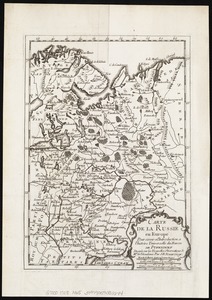
Carte de la Russie en Europe : pour servir al'Introduction a l'histoire universelle du Baron de Pufendorf
6.
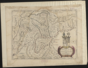
Carte de Savoye et des païs de Genevois, Faussigni, Chablais, Morienne, et Tarantaise
7.
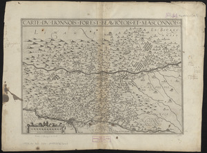
Carte du Lionnois, Forest, Beauiolois et Masconnois
8.
Cestria comitatus Palatinus = the Countye Palatine of Chester
9.
Comitatis Cantabrigiensis : vernacule Cambridge Shire
10.
Comitatus Darbiensis
11.
Comitatus Dorcestria : vulgo Anglice Dorset Shire
12.
Comitatus Northantonensis vernacule Northampton Shire
13.
Comitatus Northumbria vernacule Northumber Land
14.
Comitatus Nottinghamiensis : sive Nottingham Shire
15.
Cumbria & Westmoria : vulgo Cumberland & Westmorland
16.
De cust van Barbaria, Gualata, Arguyn en Geneheo van Capo S Vincente tot Capo Verde
17.
Description du pais de Valois
18.
Devoniae descriptio : the description of Devonshire
19.
Diocese du Mans divisee par doyennes ruraux
20.
Ducatus Eboracensis pars borealis = the Northridinge of Yorkeshire
‹ Prev
Next ›
1
2
3