Toggle navigation
LMEC Home
Exhibitions
Georeferencing
Tools for Teachers
Collections
My Favorites
Sign Up / Log In
Search
Search the map portal
Map Collection
Map Collection
Map Sets
Search
Search
Search for
Search In
All Fields
Creator
Title
Subject
Place
Search All Digital Collections
Advanced Search
32 Results
My Search
Start Over
sent
Remove constraint sent
Filter your Search
Place
North and Central America
29
United States
24
Boston Harbor
6
Boston
5
Suffolk (county)
5
Bunker Hill
4
Allegheny (county)
3
Pittsburgh
3
more
Place
»
Topic
Boston (Mass.)--Maps--Early works to 1800
4
Boston Harbor (Mass.)--Maps--Early works to 1800
4
Bunker Hill, Battle of, Boston, Mass., 1775--Maps--Early works to 1800
3
New England--History--Revolution, 1775-1783--Maps--Early works to 1800
3
Anglo-Spanish War, 1739-1748--Maps, Manuscript--Early works to 1800
2
Coasts--Florida--Maps, Manuscript--Early works to 1800
2
Dartmouth (La.)--Maps
2
Dartmouth, William Legge, Earl of, 1731-1801
2
more
Topic
»
Date
Date range begin
–
Date range end
Current results range from
1688
to
1887
View distribution
Creator
George, III, King of Great Britain, 1738-1820
6
George, IV, King of Great Britain, 1762-1830
5
Robert Sayer and John Bennett (Firm)
4
Stobo, Robert, 1726-1770
3
Campbell, John
2
Jefferys, Thomas, -1771
2
Sayer, Robert, 1725-1794
2
Todiman, Lieutenant
2
more
Creator
»
Format
Maps/Atlases
30
Manuscripts
11
Prints
2
Georeferenced
Yes
4
No
28
Collection
American Revolutionary War-Era Maps
23
Norman B. Leventhal Map Center Collection
11
British Library Collection
7
Richard H. Brown Revolutionary War Map Collection at Mount Vernon
5
William L. Clements Library Collection
5
Boston and New England Maps
4
Urban Maps
3
New-York Historical Society Collection
2
more
Collection
»
Available to use
No known restrictions
13
Creative Commons license
12
Search Constraints
Sort by relevance
relevance
title
date (asc)
date (desc)
Number of results to display per page
20 per page
10
per page
20
per page
50
per page
100
per page
View results as:
grid view
map view
Search Results
1.
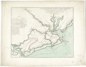
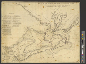
A plan of the military operations against Charlestown, the army being commanded by L.G. Sir Henry Clinton K.B. and the fleet by...
2.
A plan of the military operations against Charlestown, the army being commanded by L.G. Sir Henry Clinton K.B. and the fleet by...
3.
The seat of war, in New England, by an American volunteer : with the marches of the several corps sent by the colonies, towards...
4.
The seat of war in New England, by an American volunteer : with the marches of the several corps sent by the Colonies towards...
5.
The seat of war in New England, by an American volunteer : with the marches of the several corps sent by the Colonies towards...
6.
Hampton Roads, Virginia : from a trigonometrical survey under the direction of A.D. Bache, Superintendent of the Survey of the...
7.
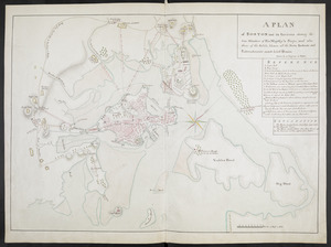
A PLAN of BOSTON and its Environs shewing the true Situation of His Majesty's Troops, and also those of the Rebels; likewise...
8.
The Seat of war, in New England
9.
Hazleton : Pennsylvania
10.
This harbour of Boston
11.
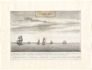
A view of part of the town of Boston in New-England and Brittish [sic] ships of war landing their troops! 1768
12.
Le Cte. d'Estaing laisse deux vaisseaux et trois frégates de son escadre à la poursuite de la frégate Anglaise la Mairmaide,...
13.
Map of the western parts of the colony of Virginia, as far as the Mississipi
14.
A map of New England, New York, New Jersey and Pensilvania
15.
Alaska and adjoining territory
16.
Dartmouth
17.
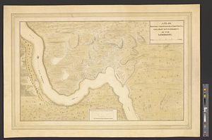
A plan shewing the situation & construction for a seat of government on the Mississippi
18.
A draught of Boston Harbor by Capt. Cyprian Southake
19.
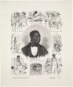
Anthony Burns
20.
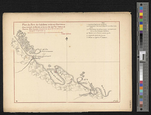
Plan du port de Calidone et de ses environs dans le Golfe de Darien et sur la cote septle de l'isthme de Panama
‹ Prev
Next ›
1
2


![A view of part of the town of Boston in New-England and Brittish [sic] ships of war landing their troops! 1768](https://bpldcassets.blob.core.windows.net/derivatives/images/commonwealth:4m90f851p/image_thumbnail_300.jpg)