Toggle navigation
LMEC Home
Exhibitions
Georeferencing
Tools for Teachers
Collections
My Favorites
Sign Up / Log In
Search
Search the map portal
Map Collection
Map Collection
Map Sets
Search
Search
Search for
Search In
All Fields
Creator
Title
Subject
Place
Search All Digital Collections
Advanced Search
45 Results
My Search
Start Over
poland/
Remove constraint poland/
Filter your Search
Place
Poland
32
Europe
23
Germany
17
Russia
6
Lithuania
5
Bohemia
4
Ukraine
4
Asia
3
more
Place
»
Topic
Poland--Maps--Early works to 1800
10
Poland--Maps
8
Germany--Maps--Early works to 1800
6
Germany--Maps
5
Czech Republic--Maps--Early works to 1800
4
Swedish-Polish War, 1655-1660--Maps--Early works to 1800
4
Bohemia (Czech Republic)--Maps--Early works to 1800
3
Pomerania (Poland and Germany)--Maps--Early works to 1800
3
more
Topic
»
Date
Date range begin
–
Date range end
Current results range from
1482
to
1920
View distribution
Creator
Dahlbergh, Erik Jönsson, greve, 1625-1703
6
Pufendorf, Samuel, Freiherr von, 1632-1694
6
Riegel, Christoph
6
Wit, Frederik de.
4
Neele, Samuel John, 1758-1824
3
Ptolemy, 2nd cent
3
American Geographical Society of New York
2
La Pointe, François de
2
more
Creator
»
Format
Maps/Atlases
44
Prints
1
Georeferenced
Yes
1
No
44
Collection
Norman B. Leventhal Map Center Collection
43
Town plans, 1794
2
Urban Maps
2
Available to use
No known restrictions
45
Search Constraints
Sort by relevance
relevance
title
date (asc)
date (desc)
Number of results to display per page
20 per page
10
per page
20
per page
50
per page
100
per page
View results as:
grid view
map view
Search Results
1.
Poland
2.
Poland
3.
Poland & Lithuania
4.
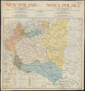
New Poland = Nowa Polska
5.
Plan of Poland (Bakerstown) surveyed by Osgood Carleton, dated 1792.
6.
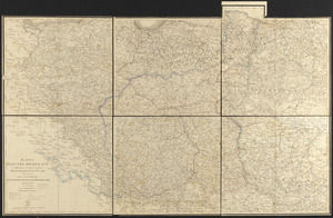
The kingdom of Poland and Great Dutchy of Lithuania with all their divisions
7.
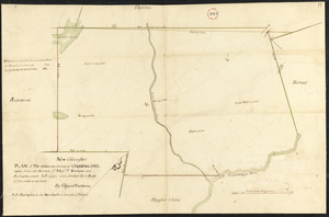
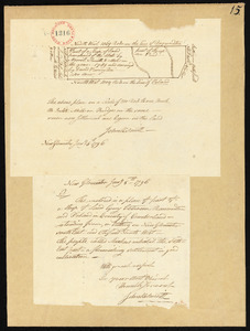
Plan of Thompson Pond Settlement between Raymondtown and Poland, made by David Purington, dated January 5, 1796.
8.
Poland, shewing the claims of Russia, Prussia & Austria, until the late depredations, the extent of which cannot as yet be...
9.
To His Most Serene and August Majesty Peter Alexovitz absolute lord of Russia &c. this map of Moscovy, Poland, Little Tartary,...
10.
Large scale map of Russia in Europe
11.
Karta T︠sarstva Pol'skago sluzhashchai︠a︡ k prodolzhenīi︠u︡ podrobnoĭ karty Rossīi sochinena pri sobstvennom" Ego...
12.
Charte von den Königreichen Preussen und Polen dem Grosherzogthum Posen nebst dem Gebiete der freien Stadt Krakau : nach dem...
13.
Preussen, der Norddeutsche bund und Dänemark
14.
Prussia
15.
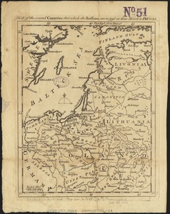
Map of the several countries thro' which the Russians are to pass in their march to Prussia
16.
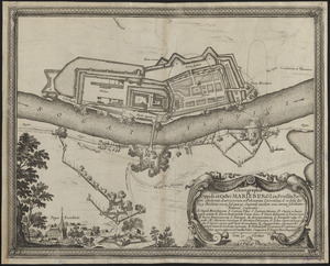
Ichnographia oppidi et castri Marieburgi in Prussia Regali, a foederatis Austriacorum, et Polonorum exercitibus, d. 12. Iulij...
17.
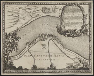
Delineatio Fortalitij Polonorum ad Lysouiam, quod a serenissimo principe Palatino Adolpho Iohanne Supremo Duce militiae...
18.
Geometrica delineatio munitionis, Dantziger Hoeft : uti illud a Gedanensibus et eorum Faederatis d. 2 Octob. obsideri caeptum,...
19.
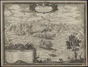
Delineatio obsidionis urbis Stetini in Pomerania à Cesareanis et Confoederatis incaeptae d. Septemb. et derelictae d. Novemb....
20.
Delineatio schenographica urbis Thoruniensis in Prussia, exhibens ejusdem obsidionem primam paulo remotius factam a rege...
‹ Prev
Next ›
1
2
3


![Delineatio schenographica urbis Thoruniensis in Prussia, exhibens ejusdem obsidionem primam paulo remotius factam a rege poloniae ejus[que]](https://bpldcassets.blob.core.windows.net/derivatives/images/commonwealth:ht2501874/image_thumbnail_300.jpg)