Toggle navigation
LMEC Home
Exhibitions
Georeferencing
Tools for Teachers
Collections
My Favorites
Sign Up / Log In
Search
Search the map portal
Map Collection
Map Collection
Map Sets
Search
Search
Search for
Search In
All Fields
Creator
Title
Subject
Place
Search All Digital Collections
Advanced Search
146 Results
My Search
Start Over
1883
Remove constraint 1883
Filter your Search
Place
North and Central America
105
United States
84
Boston
22
Suffolk (county)
22
Chile
15
Magallanes y de la Antártica Chilena
14
Asia
10
China
5
more
Place
»
Topic
Boston (Mass.)--Maps
12
Real property--Massachusetts--Boston--Maps
12
Fire risk assessment--Massachusetts--Boston--Maps
8
Coasts--Chile--Maps
6
Landowners--Massachusetts--Boston--Maps
6
Roxbury (Boston, Mass.)--Maps
5
East Boston (Boston, Mass.)--Maps
4
South Boston (Boston, Mass.)--Maps
4
more
Topic
»
Date
Date range begin
–
Date range end
Current results range from
1711
to
1935
View distribution
Creator
United States. Hydrographic Office
37
O.H. Bailey & Co
11
Sanborn, D. A. (Daniel Alfred), -1883
9
Humphreys, A. A. (Andrew Atkinson), 1810-1883
8
G.W. Bromley & Co.
6
United States. Army. Corps of Engineers
5
Collinson, Richard, Sir, 1811-1883
4
Kellett, Henry, 1806-1875
4
more
Creator
»
Format
Maps/Atlases
146
Manuscripts
2
Georeferenced
Yes
7
No
139
Collection
Norman B. Leventhal Map Center Collection
139
Urban Maps
49
Maritime Charts and Atlases
45
Boston and New England Maps
42
David Judkins Weaver Papers
4
Mapping Boston Collection
3
American Revolutionary War-Era Maps
2
New York Public Library Collection
2
more
Collection
»
Available to use
No known restrictions
138
Creative Commons license
6
Search Constraints
Sort by date (desc)
relevance
title
date (asc)
date (desc)
Number of results to display per page
20 per page
10
per page
20
per page
50
per page
100
per page
View results as:
grid view
map view
Search Results
1.
[Illustrated historical map of Shanghai]
2.
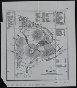
Map of Hawaii
3.
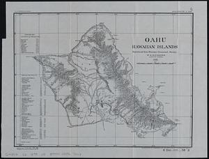
Oahu, Hawaiian Islands
4.
Railway and highway map of the famous Berkshire Hills region, showing also villages and points of interest : from official...
5.
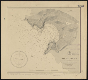
Central America, west coast of Nicaragua, San Juan del Sur
6.
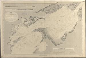
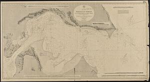
South America, Magellan Strait from the First Narrows to Broad Reach : compiled from the most recent surveys to 1883
7.
West Indies, anchorages on the north coast of Cuba
8.
West Indies, north coast of Cuba, Bahia Honda : from a Spanish plan corrected to 1883 ; West Indies, north coast of Cuba, Port...
9.
West Indies, ports on the north coast of Cuba : from Spanish government surveys corrected to 1883
10.
West Indies, ports on the north coast of Cuba : from Spanish surveys corrected to 1883
11.
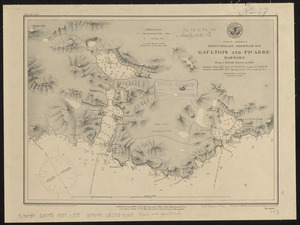
North America, Newfoundland, Hermitage Bay, Gaultois and Picarre Harbors : from a British survey in 1883
12.
South America, Magellan Strait from the eastern entrance to the First Narrows : compiled from the most recent surveys to 1883
13.
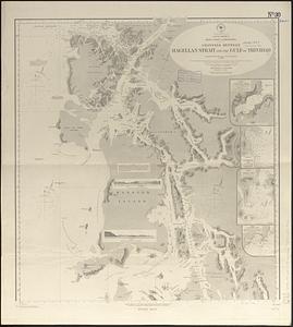
South America, west coast of Patagonia, channels between Magellan Strait and the Gulf of Trinidad : compiled from the most...
14.
West Indies, ports on the north coast of Cuba : from Spanish surveys corrected to 1883
15.
West Indies, ports on the north coast of Cuba : from Spanish government surveys corrected to 1883
16.
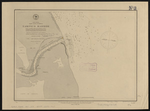
North America, east coast of Mexico, Tampico Harbor : from a survey in 1883 by the officers of the U.S.S. Alliance, Commander...
17.
South Pacific Ocean, Caroline Island
18.
West Indies, north coast of Cuba, Port Tanamo : from a Spanish plan, corrected to 1883 ; West Indies, north coast of Cuba, Port...
19.
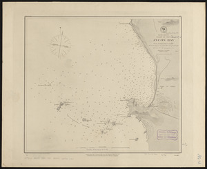
South America, coast of Peru, Ancon Bay : from an Italian survey in 1883
20.
Atlas of the city of Boston : Charlestown and Brighton, volume six : from actual surveys and official records
‹ Prev
Next ›
1
2
3
4
5
…
7
8
![[Illustrated historical map of Shanghai]](https://bpldcassets.blob.core.windows.net/derivatives/images/commonwealth:qb98n805r/image_thumbnail_300.jpg)