Toggle navigation
LMEC Home
Exhibitions
Georeferencing
Tools for Teachers
Collections
My Favorites
Sign Up / Log In
Search
Search the map portal
Map Collection
Map Collection
Map Sets
Search
Search
Search for
Search In
All Fields
Creator
Title
Subject
Place
Search All Digital Collections
Advanced Search
150 Results
My Search
Start Over
1873
Remove constraint 1873
Filter your Search
Place
North and Central America
88
United States
58
Europe
18
Boston
16
Suffolk (county)
16
Asia
11
Canada
9
Mexico
7
more
Place
»
Topic
Pictorial maps
12
Boston (Mass.)--Maps
8
California, Gulf of (Mexico)--Maps
4
United States--Maps
4
Cambridge (Mass.)--Maps
3
Canada--Maps
3
Great Fire, Boston, Mass., 1872--Maps
3
Landowners--Massachusetts--Boston--Maps
3
more
Topic
»
Date
Date range begin
–
Date range end
Current results range from
1625
to
1985
View distribution
Creator
United States. Hydrographic Office
48
Harvey, William, 1796-1873
12
Hodder and Stoughton
12
Lancaster, Elizabeth Lilian, 1852-1939
12
Vincent Brooks, Day & Son
12
Maury, Matthew Fontaine, 1806-1873
5
Beers, F. W. (Frederick W.)
4
Comstock, C. B. (Cyrus Ballou), 1831-1910
4
more
Creator
»
Format
Maps/Atlases
150
Manuscripts
1
Georeferenced
Yes
16
No
134
Collection
Norman B. Leventhal Map Center Collection
140
Maritime Charts and Atlases
53
Urban Maps
38
Boston and New England Maps
35
Massachusetts Real Estate Atlases
3
Town plans, 1830
3
American Revolutionary War-Era Maps
2
Boston Redevelopment Authority Collection
1
more
Collection
»
Available to use
No known restrictions
144
Creative Commons license
3
Search Constraints
Sort by relevance
relevance
title
date (asc)
date (desc)
Number of results to display per page
20 per page
10
per page
20
per page
50
per page
100
per page
View results as:
grid view
map view
Search Results
1.
Boston, Feb. 20 1873
2.
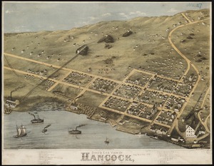
Bird's eye view of Hancock, L.S. Mich, 1873 : looking north west
3.
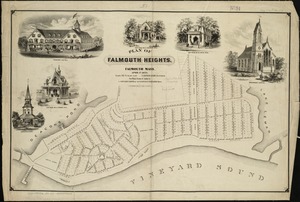
Plan of Falmouth Heights, Falmouth Mass., April 1st 1873
4.
Carte du Bassin du Mackenzie, dressée de 1862 à 1873
5.
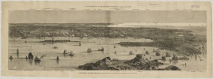
Map of the principal part of Boston, and adjacent cities, for 1873
6.
Progress chart of the Survey of the Northern & North Western Lakes, July 1st, 1873 : primary triangulation, telegraphic...
7.
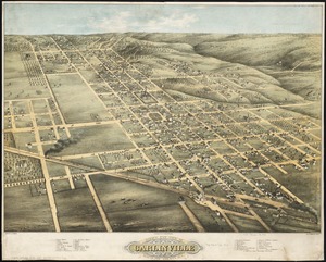
Bird's eye view of Carlinville, Macoupin County Ill : 1873
8.
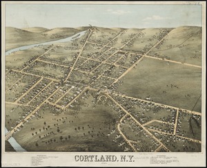
Cortland, N.Y : 1873
9.
Map showing in five degrees of density the distribution of woodland within the territory of the United States, 1873
10.
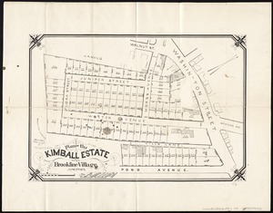
Plan of the Kimball Estate in Brookline Village : June 2nd 1873
11.
Bird's eye view of Waterloo : Seneca County, N.Y., 1873
12.
Chart of Boston Harbor : from the best authorities, 1873
13.
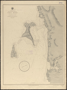
Dominion of Canada, Gulf of Saint Lawrence, Port Hood (Cape Breton Island) : from British surveys in 1847 & 1873
14.
West Indies--Bahama Islands, Inagua Island anchorages : from British surveys, corrected to 1873
15.
Newport, Rhode Island
16.
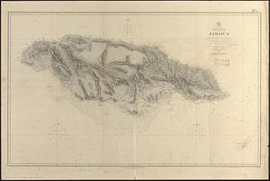
North America, east coast, West Indies, Jamaica : from British surveys from 1873 to 1881
17.
North Pacific Ocean, Caroline Islands, Seniavine Islands : from French, Russian and U.S. surveys, corrected to 1873
18.
West Indies, harbors on Dominica Island : republished from the Brt. Admty. chart of June 1873
19.
Indian Ocean, Gulf of Aden--North coast, Aden and adjacent bays : republished from the Brit. Admty chart no. 7, corrected to 1873
20.
Japan-Yezo Id., e. coast, Akishi Bay : republished from the Brt. Admty. chart no. 992, corrected to 1873
‹ Prev
Next ›
1
2
3
4
5
…
7
8