Toggle navigation
LMEC Home
Exhibitions
Georeferencing
Tools for Teachers
Collections
My Favorites
Sign Up / Log In
Search
Search the map portal
Map Collection
Map Collection
Map Sets
Search
Search
Search for
Search In
All Fields
Creator
Title
Subject
Place
Search All Digital Collections
Advanced Search
136 Results
My Search
Start Over
1772
Remove constraint 1772
Filter your Search
Place
North and Central America
91
United States
32
Canada
24
New France
10
Haiti
9
New York
9
North America
9
Hispaniola
7
more
Place
»
Topic
Canada--Maps--Early works to 1800
10
Haiti--Maps--Early works to 1800
7
Hispaniola--Maps--Early works to 1800
7
New France--Maps
7
Cape Verde--Maps--Early works to 1800
6
Africa, West--Maps--Early works to 1800
5
North America--Maps
5
Great Lakes (North America)--Maps
4
more
Topic
»
Date
Date range begin
–
Date range end
Current results range from
1738
to
1919
View distribution
Creator
Bellin, Jacques Nicolas, 1703-1772
88
Sayer, Robert, 1725-1794
4
Andrews, Peter, active 1765-1782
3
De Brahm, John Gerar William, 1717-ca. 1799
3
Robert de Vaugondy, Didier, 1723-1786
3
Amherst, Jeffery Amherst, Baron, 1717-1797
2
Bowen, Emanuel, d. 1767
2
Carey, Mathew, 1760-1839
2
more
Creator
»
Format
Maps/Atlases
135
Manuscripts
9
Prints
1
Georeferenced
Yes
3
No
133
Collection
American Revolutionary War-Era Maps
102
Norman B. Leventhal Map Center Collection
61
William L. Clements Library Collection
38
Maritime Charts and Atlases
15
American Antiquarian Society Collection
10
Library and Archives Canada Collection
8
Mapping Boston Collection
6
Boston and New England Maps
5
more
Collection
»
Available to use
No known restrictions
56
Creative Commons license
19
Search Constraints
Sort by relevance
relevance
title
date (asc)
date (desc)
Number of results to display per page
20 per page
10
per page
20
per page
50
per page
100
per page
View results as:
grid view
map view
Search Results
1.
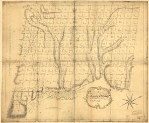
A plan of the township of Blenheim, as surveyed and divided in the year 1772
2.
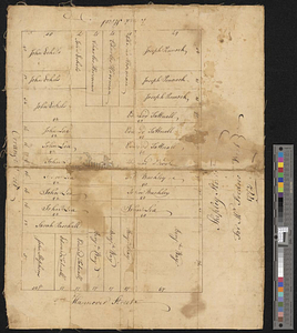
Plan of a city block in Wilmington, Delaware : for Mr Fredrick Wirt 1772
3.
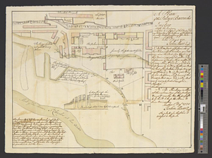
A plan of the Palace Barracks at Quebec with the environs, relative to a report of this date and an estimate of the expence of...
4.
A general plan of the harbours of Port Royal and Kingston Jamaica with the channels leading thereto, and the kays and shoals...
5.
A plan of the division line between the provinces of New-York and Quebec : In the 45th degree of north latitude. Survey'd in...
6.
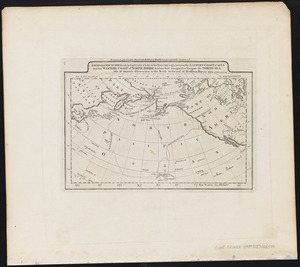
A map of the discoveries made by Capts. Cook & Clerke in the years 1778 & 1779 between the eastern coast of Asia and the...
7.
A chart of the world upon Mercator's projection : describing the tracks of Capt. Cook in the year 1768, 69, 70, 71, and in...
8.
A Plan of that part of the boundary between the states of North and South Carolina : lying between that part of said boundary...
9.
A general map of North America drawn from the best surveys 1795
10.
New Hampshire by recent survey : made under the supreme authority and published according to law
11.
Pianta della città di Firenze
12.
Plan de la ville de Louisbourg avec les ouvrages d'attaque des Anglais pour sa reddition, ainsi que ceux des assiegés pr. la...
13.
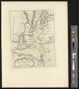
Baye et port d'Yorc, capitale de la Nouvelle Yorc
14.
Baye et port d'Yorc capitale de la Nouvelle Yorc
15.
Carte de la Baye de Baston : située dans la Nouvelle Angleterre
16.
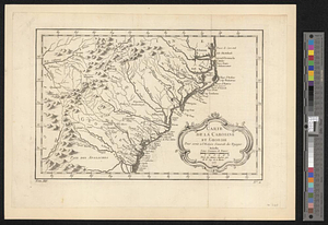
Carte de la Caroline at Georgie pour servir à l'histoire générale des voyages : tirée des auteurs Anglois
17.
Carte de la Caroline et Georgie. : Pour servir à l'Histoire générale des voyages
18.
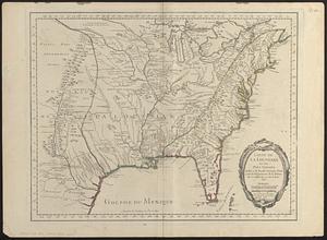
Carte de la Floride, de la Louisiane, et pays voisins. : Pour servir à l'Histoire générale des voyages
19.
Carte de la Louisiane cours du Mississipi et pais voisins : dediée à M. le Comte de Maurepas, ministre et secretaire d'etat...
20.
Carte de la Louisiane et des pays voisins dédiée à M. Rouillé sécretaire d'état, ayant le Département de la marine
‹ Prev
Next ›
1
2
3
4
5
6
7