Toggle navigation
LMEC Home
Exhibitions
Georeferencing
Tools for Teachers
Collections
My Favorites
Sign Up / Log In
Search
Search the map portal
Map Collection
Map Collection
Map Sets
Search
Search
Search for
Search In
All Fields
Creator
Title
Subject
Place
Search All Digital Collections
Advanced Search
56 Results
My Search
Start Over
g3201
Remove constraint g3201
Filter your Search
Place
World
53
Germany
2
Topic
World maps
36
Pictorial maps
8
Telegraph lines--Maps
8
Map projection
3
Telecommunication--Maps
3
Trade routes--Maps
3
World War, 1939-1945--Maps
3
World maps--Early works to 1800
3
more
Topic
»
Date
Date range begin
–
Date range end
Current results range from
1668
to
2006
View distribution
Creator
Chase, Ernest Dudley, 1878-
6
International Telegraph Bureau (Bern, Switzerland)
4
ODT, Inc
3
Chase, Ernest Dudley, 1878-1966
2
United States. Hydrographic Office
2
Van Hoven, C.
2
Whiting, Oliver K.
2
Abizaid, John George, 1868-
1
more
Creator
»
Format
Maps/Atlases
55
Objects/Artifacts
1
Prints
1
Georeferenced
Yes
2
No
54
Collection
Norman B. Leventhal Map Center Collection
56
American Revolutionary War-Era Maps
2
Available to use
No known restrictions
53
Search Constraints
Sort by date (desc)
relevance
title
date (asc)
date (desc)
Number of results to display per page
50 per page
10
per page
20
per page
50
per page
100
per page
View results as:
grid view
map view
Search Results
1.
Peters World map
2.
The population map
3.
The world's most populous countries
4.
Physical map of the world, April 2001
5.
A pictorial stamp map of navigation and exploration
6.
World freedom : a factual & pictorial map
7.
The pictorial map, a world of stamps
8.
Mercator map of the world united : a pictorial history of transport and communications and paths to permanent peace
9.
Peace map of the world united : a pictorial history of transportation and communications from Jonah to the jet plane as paths...
10.
The story map of flying : being a chronicle of man's conquest of the air
11.
World map of the major tropical diseases
12.
Global map for global war and global peace
13.
Invasion and total war victory maps : with decorations, illustrations and military and naval insignia
14.
Total war battle map
15.
Reg Manning's table-top argu-map of the world
16.
World wonders : a pictorial map
17.
Philips Radio
18.
Racing routes of the Yankee clippers
19.
Wereldkaart "reis om de wereld"
20.
The new map of the world
21.
The League of Nations, 1925
22.
New correct map of the flat surface, stationary earth
23.
Airways of the world on Mercator's projection
24.
Map no. 245
25.
Track chart U.S. dry dock Dewey : Solomons to Olongapo, December 28, 1905-July 10, 1906
26.
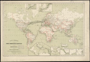
Carte générale des grandes communications télégraphiques du monde
27.
Carte des communications télégraphiques du régime extra-européen
28.
Kaufmännische wandkarte der erde zur übersicht der handelsbeziehungen, dampfer- und kabel-verbindungen des Deutschen Reiches...
29.
Carte générale des grandes communications télégraphiques du monde
30.
Chart of the world showing area in the Pacific Ocean having Hawaii as the only base of supplies in transpacific voyages and...
31.
Caerte van de voornaemste reysen ende ontdeckingen door de Hollanders gedaen, alsook vande landen, plaetsen ende factoriën in...
32.
American Radiator Company trade card
33.
Carte des communications télégraphiques du régime extra-européen
34.
Gleason's new standard map of the world : on the projection of J. S. Christopher, Modern College, Blackheath, England ;...
35.
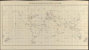
Map showing recorded dates of influenza epidemic in 1889 and 1890
36.
Submarine cable chart of the world : showing also the seacoast stations and the principal connecting land lines ; for the use...
37.
Magnetic variation chart for the year 1882
38.
[Mid]dleton's [pione]er map of the [w]orld, [as a?] plane and immoveable
39.
Map showing the telegraph lines in operation, under contract, and contemplated, to complete the circuit of the globe
40.
Map of Boston and adjacent country showing that city to be the geographical as well as intellectual and moral centre of one...
41.
Map showing the telegraph lines in operation, under contract, and contemplated, to complete the circuit of the globe
42.
Welt-karte zur übersicht der meeres-strömungen und des schnellverkehrs
43.
Plastischer schul-atlas
44.
P. McD. Collins' proposed overland telegraph : via Behrings Strait and asiatic Russia to Europe, under Russian & British grants
45.
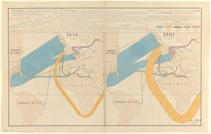
Carte figurative et approximative des quantités de coton en laine importées en Europe en 1858 et en 1861
46.
The world, on Mercator's projection : showing the different routes to California, and distance by each; routes of different...
47.
Chart of the world, on Mercator's projection : illustrative of the impolicy of slavery
48.
Comparative view of the heights of the principal mountains &c. in the world
49.
Orbis veteribus notus scilicet: Europe, Asia, Africa publici juris factus
50.
The World
‹ Prev
Next ›
1
2


![[Mid]dleton's [pione]er map of the [w]orld, [as a?] plane and immoveable](https://bpldcassets.blob.core.windows.net/derivatives/images/commonwealth:7h149v84p/image_thumbnail_300.jpg)