Toggle navigation
LMEC Home
Exhibitions
Georeferencing
Tools for Teachers
Collections
My Favorites
Sign Up / Log In
Search
Search the map portal
Map Collection
Map Collection
Map Sets
Search
Search
Search for
Search In
All Fields
Creator
Title
Subject
Place
Search All Digital Collections
Advanced Search
63 Results
My Search
Start Over
immigration
Remove constraint immigration
Filter your Search
Place
North and Central America
51
United States
47
Boston
34
Suffolk (county)
34
Massachusetts
3
South America
3
California
2
Canada
2
more
Place
»
Topic
Boston (Mass.)--Maps
24
Immigrants--Massachusetts--Boston--Maps
18
Immigrants--Massachusetts--Boston
9
United States--Maps
3
Cape Verdeans--Massachusetts--Boston--Maps
2
Chinese--Massachusetts--Boston--Maps
2
Dominicans--Massachusetts--Boston--Maps
2
Globe Newspaper Co.
2
more
Topic
»
Date
Date range begin
–
Date range end
Current results range from
1670
to
2023
View distribution
Creator
Boston Planning and Development Agency
8
Boston Redevelopment Authority. Office of Digital Cartography & GIS
7
Boston Public Library. Norman B. Leventhal Map and Education Center
3
Hine, Lewis Wickes, 1874-1940
3
O.H. Bailey & Co
3
Boston Redevelopment Authority
2
Huffman, Daniel P.
2
Manitoba. Department of Agriculture and Immigration
2
more
Creator
»
Format
Maps/Atlases
53
Photographs
9
Prints
1
Georeferenced
Yes
23
No
40
Collection
Norman B. Leventhal Map Center Collection
61
Boston and New England Maps
10
Urban Maps
9
American Revolutionary War-Era Maps
2
Richard H. Brown Revolutionary War Map Collection at Mount Vernon
2
Available to use
No known restrictions
58
Creative Commons license
5
Search Constraints
Sort by relevance
relevance
title
date (asc)
date (desc)
Number of results to display per page
100 per page
10
per page
20
per page
50
per page
100
per page
View results as:
grid view
map view
Search Results
1.
A nation of immigrants
2.
Boston's top 5 immigrant populations
3.
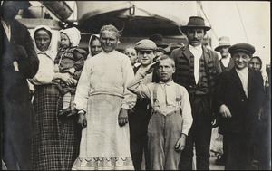
Immigrant boy salutes flag on ship in Boston harbor
4.
Texas New Yorker's railroad map of Texas : showing all completed and proposed routes, with principal rivers, county boundaries...
5.
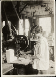
15-year old girl punching cards. Boston Index Card Co., 113 Purchase Street.
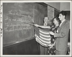
6.
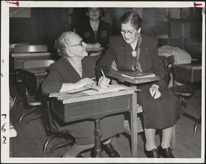
Age is no bar to studying for American citizenship
7.
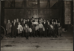
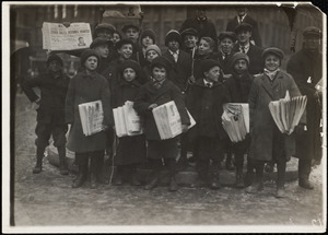
Boston Globe Newsboys on Newspaper Row
8.
Boston Globe Newsies
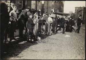
9.
Boy Peddling Notions, Downtown Boston
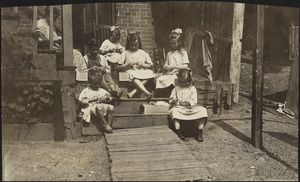
10.
Family of Mrs. Donovan, Roxbury
11.
School for newcomers, Temple Kehillath Israel
12.
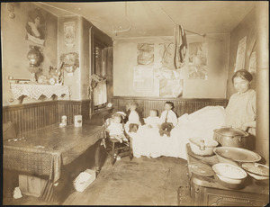
Tenement Apartment, Boston
13.
Boston neighborhoods : top 10 countries of birth for foreign-born population
14.
Boston's diversity index, 2010 : measures of diversity : region of birth
15.
Boston's neighborhoods by percentage of foreign-born (by census tract)
16.
Percent foreign-born
17.
Total foreign-born
18.
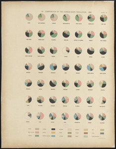
Composition of the foreign-born population : 1890
19.
Boston's top foreign-born populations : Dominicans
20.
Boston's top foreign-born populations : Haitians
21.
Boston's top foreign-born populations : Chinese
22.
Boston's top foreign-born populations : Vietnamese
23.
Boston's top foreign-born populations : Salvadorans
24.
Boston's top foreign-born populations : Haitians
25.
Boston's top foreign-born populations : Dominicans
26.
Boston's top foreign-born populations : Salvadorans
27.
Boston's top foreign-born populations : Chinese
28.
Boston's top foreign-born populations : Vietnamese
29.
Boston's top foreign-born populations : Cape Verdeans
30.
Boston's top foreign-born populations : Cape Verdeans
31.
Makers of the U.S.A. : a friendship map
32.
Boston public services
33.
Peru
34.
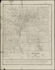
Official map of New Mexico
35.
Map of Manitoba
36.
Map of Manitoba
37.
Official map of the territory of Dakota, showing the two general divisions of Dakota, South and North, the land districts,...
38.
New map of the American overland route showing its connections, and land grants of 30,000,000 acres
39.
Course of cholera in Boston in 1849
40.
Map of Boston and suburbs
41.
Meiguo Sanfan Shi hua qiao qu : xiang xi tu = Map of San Francisco Chinatown
42.
Nationalities map no. 1 - Polk Street to Twelfth, Halsted Street to Jefferson, Chicago ; Nationalities map no. 2 - Polk Street...
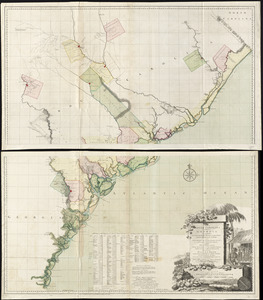
43.
A map of South Carolina and a part of Georgia : containing the whole sea-coast; all the islands, inlets, rivers, creeks,...
44.
Ireland, from the best authorities : with distances in miles from Dublin
45.
Map of the metropolitan district of Boston, Massachusetts : showing the existing public reservations and such new open spaces...
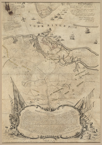
46.
To His Excellency Genl. Washington, Commander in Chief of the armies of the United States of America : this plan of the...
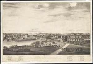
47.
View of Lowell, Mass : taken from the house of Elisha Fuller Esq. in Dracut
48.
Hazleton : Pennsylvania
49.
Map of an exploring expedition to the Rocky Mountains in the year 1842 and to Oregon & north California in the years 1843-44
50.
Plano de Asuncion
51.
Bird's eye view of Boston
52.
Map of the mining district of California
53.
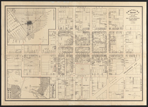
Plan of the city of Lowell, Massachusetts
54.
View of the city of New Bedford, Mass : 1876
55.
Home rule map of Ireland
56.
Novissima et accuratissima totius Americae descriptio
57.
Haverhill, Massachusetts : 1893
58.
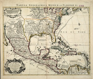
Carte du Mexique et de la Florida : des terres angloises et des Isles Antilles, du cours et des environs de la Riviere de...
59.
Boston streets & neighborhoods
60.
Boston's top 5 foreign languages spoken at home, 2015
61.
The Seventh Ward of Philadelphia : the distribution of Negro inhabitants throughout the ward, and their social conditions
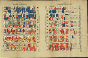
62.
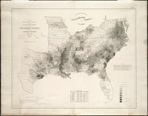
Map showing the distribution of the slave population of the southern states of the United States
63.
Amerique meridionale divisée en ses principales parties ou sont distingués les vns des autres les estats suivant qu'ils...