Toggle navigation
LMEC Home
Exhibitions
Georeferencing
Tools for Teachers
Collections
My Favorites
Sign Up / Log In
Search
Search the map portal
Map Collection
Map Collection
Map Sets
Search
Search
Search for
Search In
All Fields
Creator
Title
Subject
Place
Search All Digital Collections
Advanced Search
13385 Results
Filter your Search
Place
North and Central America
9,353
United States
7,078
Suffolk (county)
1,664
Boston
1,621
Europe
1,035
Canada
949
Massachusetts
794
New York
532
more
Place
»
Topic
Boston (Mass.)--Maps
741
City planning--Massachusetts--Boston--Maps
418
United States--History--Revolution, 1775-1783--Maps
329
United States--Maps
315
Urban renewal--Massachusetts--Boston--Maps
254
Real property--Massachusetts--Boston--Maps
252
Massachusetts--Maps
219
Insurance surveys
197
more
Topic
»
Date
Date range begin
–
Date range end
Current results range from
1482
to
2023
View distribution
Creator
United States. Hydrographic Office
595
Boston Redevelopment Authority
403
Des Barres, Joseph F. W. (Joseph Frederick Wallet), 1722-1824
247
Royal United Services Institute for Defence and Security Studies
160
Jefferys, Thomas, -1771
154
George, III, King of Great Britain, 1738-1820
152
George, IV, King of Great Britain, 1762-1830
151
O.H. Bailey & Co
148
more
Creator
»
Format
Maps/Atlases
13,205
Manuscripts
985
Prints
102
Books
49
Drawings/Illustrations
44
Photographs
15
Objects/Artifacts
13
Documents
7
more
Format
»
Georeferenced
Yes
979
No
12,406
Collection
Norman B. Leventhal Map Center Collection
8,891
American Revolutionary War-Era Maps
3,305
Boston and New England Maps
2,804
Urban Maps
2,397
Maritime Charts and Atlases
1,150
William L. Clements Library Collection
910
Library of Congress Collection
618
Boston Redevelopment Authority Collection
475
more
Collection
»
Available to use
No known restrictions
9,952
Creative Commons license
1,677
Search Constraints
Sort by date (asc)
relevance
title
date (asc)
date (desc)
Number of results to display per page
100 per page
10
per page
20
per page
50
per page
100
per page
View results as:
grid view
map view
Search Results
9401.
Map of the city of Beloit, Wisconsin, 1887
9402.
Map of the Department of the Columbia
9403.
Map of the rail roads of New Jersey 1887
9404.
Map of the railroads of the state of Massachusetts : accompanying the report of the railroad commissioners : 1887
9405.
Map of the State of Rhode Island and Providence Plantations
9406.
A map of the town of Providence from actual survey
9407.
Map of the United States
9408.
Massachusetts Bay with the coast from Cape Ann to Cape Cod
9409.
M'bua or Sandalwood Bay, Island of Vanua Levu, Feejee Group
9410.
Mediterranean, anchorages on the east coast of Spain : from Spanish government surveys of 1878
9411.
Millville, Massachusetts : 1887
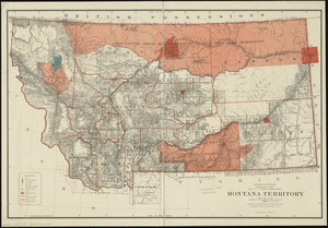
9412.
Montana Territory
9413.
Mouth of the Teen-tsin-ho or Pei-ho and approach to the Sha-lui-tien banks
9414.
Needham, Massachusetts, 1887
9415.
New dissected map of the United States
9416.
North America, Bay of Fundy, Grand Manan Island and adjacent coast : from surveys by the British Admiralty in 1855, and by the...
9417.
North America, east coast, coast of Labrador from Cape St. Charles to Sandwich Bay : from British surveys to 1882
9418.
North America, east coast of Mexico, Tampico Harbor : from a survey in 1883 by the officers of the U.S.S. Alliance, Commander...
9419.
North America, west coast, anchorages in the Gulf of California : from a survey by Commander Geo. Dewey, U.S.N. and the...
9420.
North America, west coast, anchorages on the south coast of Lower California
9421.
North America, west coast, Gulf of California, Mexico, Guaymas Harbor and approaches : from the most recent surveys, verified...
9422.
North America, west coast, harbors on the west coast of Mexico : from a survey by Commander J.W. Philip, U.S.N. and the...
9423.
North America, west coast of Mexico, Port San Blas : from a British survey in 1822, corrected for the latest information, 1887
9424.
North America, west coast, west coast of lower California, Cerros Island and vicinity
9425.
North America, west coast, west coast of Mexico from Chipequa Pt. to Ventosa Bay : showing the anchorages in Chipequa, Conejo,...
9426.
North Billerica, Mass : 1887
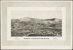
9427.
North Leominster, Mass
9428.
North Pacific Ocean, Caroline Group - Ponapi Island, Jamestown Harbor : from a survey in 1870 by the officers of the U.S.S....
9429.
North Pacific Ocean, Marshall Islands, Likieb Group : from a sketch made by Captain J.V. Melander in 1885
9430.
Penacook, N.H
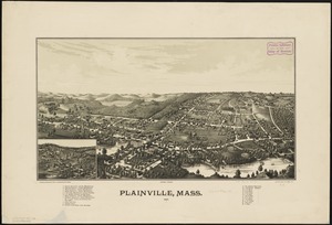
9431.
Plainville, Mass : 1887
9432.
Plan of Rowe's Wharf
9433.
Plan of Sorrento, Maine
9434.
Plan of the city intended for the permanent seat of the government of t[he] United States : projected agreeable to the...
9435.
Plan of the Siege of Yorktown, 1781
9436.
Preliminary map of Kentucky
9437.
Raritona Harbour, Island Ya-Asaua, Asaua Group ; Emmons Bay, Island of Ya-Asaua, Asaua Group ; Faliki Harbour, east side of...
9438.
Rochdale and Greenville, Mass : 1887
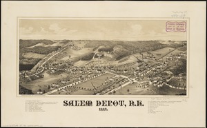
9439.
Salem Depot, N.H : 1887
9440.
South America--south west coast--inner channels, Indian Reach : from British surveys corrected to 1881
9441.
South Pacific Ocean, Caroline Island
9442.
South Pacific Ocean, Paumotu Group - Rairoa (Rangiroa) Island, Avatoru Pass and anchorage
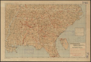
9443.
Southern States
9444.
Southville and Cordaville, Massachusetts, 1887
9445.
St. Lawrence Bay showing Lutke's Harbor
9446.
State of Colorado
9447.
State of Louisiana
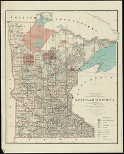
9448.
State of Minnesota
9449.
State of Ohio
9450.
Submarine cable chart of the world : showing also the seacoast stations and the principal connecting land lines ; for the use...
9451.
Tabulae maximae quibus illustrantur terrae veterum in usum scholarum
9452.
Tabulae maximae quibus illustrantur terrae veterum in usum scholarum
9453.
Taiara or King's Island ; Henuake, Honden or Dog Id. ; Penrhyns Island ; Two groups
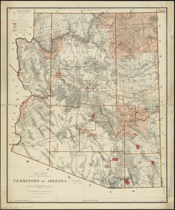
9454.
Territory of Arizona
9455.
View of Grafton, Massachusetts : 1887
9456.
View of Medway, Massachusetts : 1887
9457.
View of Northborough, Massachusetts : 1887
9458.
View of Somerset, Massachusetts
9459.
Warner, N.H : 1887
9460.
Washington Territory
9461.
West Indies, Little Bahama Bank, Whale Cay Channel and Green Turtle Cay anchorage : from a British survey in 1882-3
9462.
West Indies, north coast of Cuba, Port Tanamo : from a Spanish plan, corrected to 1883 ; West Indies, north coast of Cuba, Port...
9463.
West Indies, Roatan Island, Coxen Hole : from an English plan published in 1843 ; West Indies, Roatan Island, Port Royal Harbor...
9464.
West Medway, Massachusetts : 1887
9465.
Winchester, N.H : Cheshire County, 1887
9466.
Wood's Holl [sic], Falmouth, Mass
9467.
Yaggy's geographical study [title page] : comprising physical, political, geological and astronomical geography
9468.
Alton and Alton Bay, N.H : 1888
9469.
The Arctic Ocean between Greenland and Nova Zemla and between the 60th and 82d parallels of latitude : from the Swedish,...
9470.
Asia, east coast, China Sea in four sheets : compiled from the latest surveys 1885
9471.
Asiae Minoris antiquae : tabula in usum scholarum descripta
9472.
Atlas of the city of Boston : city proper, volume one : from actual surveys and official plans
9473.
Atlas of the city of Boston : city proper, volume two : from actual surveys and official plans
9474.
Atlas of the city of Boston : Roxbury, Mass. : volume three : from actual surveys and official records
9475.
Atlas of the town of Brookline, Norfolk County, Massachusetts : from actual surveys and official plans
9476.
Azores or Western Islands
9477.
Bay of Avatcha and approaches
9478.
Bay of Massefao, island of Tutuila ; Bay of Fagaitui, island of Tutuila ; Sketch of Aluau Bay, 1839 ; Tutuila Isld., approaches...
9479.
Berlin Falls, N.H., and Berlin Mills : 1888
9480.
Block Island, Rhode Island
9481.
Boston Bay and Harbor
9482.
Boston Highlands, Massachusetts : Wards 19, 20, 21 & 22 of Boston
9483.
Bridgton, Maine : U.S.A., 1888
9484.
Buctouche, New Brunswick
9485.
The Canary Islands : from British surveys in 1834 and 1838 corrected to 1871
9486.
Cape Verde Islands, Porto Grande in the island of St. Vincent
9487.
Caribbean Sea--Yucatan, special plans to chart no. 401 : from British surveys, corrected to 1872
9488.
Central America, British Honduras, Belize Harbor : from a British Survey in 1829 & 30
9489.
Central America, west coast of Costa Rica, Gulf of Dulce
9490.
Central America, west coast of Costa Rica, Gulf of Nicoya
9491.
Central America, west coast of Costa Rica, Juanilla Bay : from a survey in 1885 by the officers of the U.S.S. Ranger, Commander...
9492.
Central America, west coast of Costa Rica, Murcielago Bay : from a survey in 1885 by the officers of the U.S.S. Ranger,...
9493.
Central America, west coast of Costa Rica, Potrero and Braxilito Bays : from a survey in 1885 by the officers of the U.S.S....
9494.
Central America, west coast of Costa Rica, Potrero Grande Bay : from a survey in 1885 by the officers of the U.S.S. Ranger,...
9495.
Central America, west coast of Costa Rica, Punta Arenas anchorage (Gulf of Nicoya) : from a survey in 1885 by the officers of...
9496.
Central America, west coast of Costa Rica, Uvita Bay : from a survey in 1885 by the officers of the U.S.S. Ranger, Commander...
9497.
Central America, west coast of Nicaragua, Salinas Bay : from a survey in 1885 by the officers of the U.S.S. Ranger, Commander...
9498.
Central-America, southern shore of the Caribbean Sea, harbor of San Juan del Norte or Greytown
9499.
A chart of the Cape Verd Islands
9500.
Cuba, south coast, approaches to Ports Casilda and Masio with the adjacent anchorages : from a Spanish government chart of 1879
‹ Prev
Next ›
1
2
…
91
92
93
94
95
96
97
98
99
…
133
134