Toggle navigation
LMEC Home
Exhibitions
Georeferencing
Tools for Teachers
Collections
My Favorites
Sign Up / Log In
Search
Search the map portal
Map Collection
Map Collection
Map Sets
Search
Search
Search for
Search In
All Fields
Creator
Title
Subject
Place
Search All Digital Collections
Advanced Search
13385 Results
Filter your Search
Place
North and Central America
9,353
United States
7,078
Suffolk (county)
1,664
Boston
1,621
Europe
1,035
Canada
949
Massachusetts
794
New York
532
more
Place
»
Topic
Boston (Mass.)--Maps
741
City planning--Massachusetts--Boston--Maps
418
United States--History--Revolution, 1775-1783--Maps
329
United States--Maps
315
Urban renewal--Massachusetts--Boston--Maps
254
Real property--Massachusetts--Boston--Maps
252
Massachusetts--Maps
219
Insurance surveys
197
more
Topic
»
Date
Date range begin
–
Date range end
Current results range from
1482
to
2023
View distribution
Creator
United States. Hydrographic Office
595
Boston Redevelopment Authority
403
Des Barres, Joseph F. W. (Joseph Frederick Wallet), 1722-1824
247
Royal United Services Institute for Defence and Security Studies
160
Jefferys, Thomas, -1771
154
George, III, King of Great Britain, 1738-1820
152
George, IV, King of Great Britain, 1762-1830
151
O.H. Bailey & Co
148
more
Creator
»
Format
Maps/Atlases
13,205
Manuscripts
985
Prints
102
Books
49
Drawings/Illustrations
44
Photographs
15
Objects/Artifacts
13
Documents
7
more
Format
»
Georeferenced
Yes
979
No
12,406
Collection
Norman B. Leventhal Map Center Collection
8,891
American Revolutionary War-Era Maps
3,305
Boston and New England Maps
2,804
Urban Maps
2,397
Maritime Charts and Atlases
1,150
William L. Clements Library Collection
910
Library of Congress Collection
618
Boston Redevelopment Authority Collection
475
more
Collection
»
Available to use
No known restrictions
9,952
Creative Commons license
1,677
Search Constraints
Sort by date (desc)
relevance
title
date (asc)
date (desc)
Number of results to display per page
20 per page
10
per page
20
per page
50
per page
100
per page
View results as:
grid view
map view
Search Results
11841.
North America from the French of Mr. D'Anville, improved with the back settlements of Virginia and course of Ohio, illustrated...
11842.
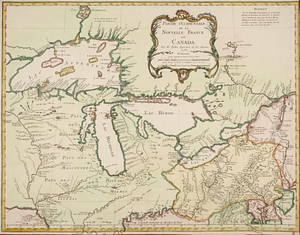
Partie de l'Amérique septent? qui comprend la Nouvelle France ou le Canada
11843.
Partie de l'Amerique Septentrionale, : qui comprend le cours de l'Ohio, la Nlle. Angleterre, la Nlle. York, le New Jersey, la...
11844.
Partie de l'Amérique septentrionale, qui comprend le cours de l'Ohio, la Nlle. Angleterre, la Nlle York, le New Jersey, la...
11845.
Partie occidentale de la Nouvelle France ou Canada
11846.
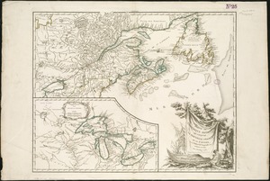
Partie orientale de la Nouvelle France ou du Canada
11847.
Partie orientale de la Nouvelle France ou du Canada
11848.
Plan de Boston
11849.
Plan de Boston
11850.
Plan de la ville de Boston et ses environs
11851.
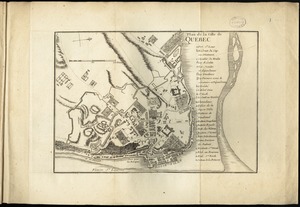
Plan de la ville de Quebec
11852.
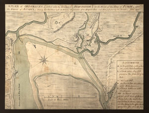
A plan of Chignecto (called also by the French Beau-Bassin) at the head of the Bay of Fundi upon the Istmus of Accadia shewing...
11853.
A PLAN of FORT CUMBERLAND on Will's CREEK & POTOMACK River with a View of the Store Houses belonging to the OHIO COMPANY on the...
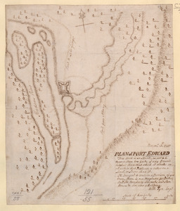
11854.
PLAN of FORT EDWARD
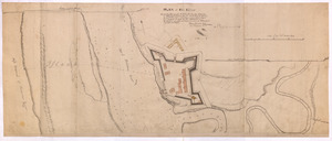
11855.
PLAN of Fort Edward
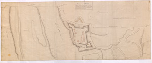
11856.
PLAN of Fort EDWARD
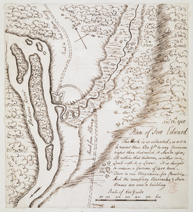
11857.
Plan of Fort Edward
11858.
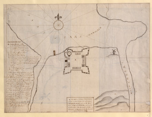
A PLAN of FORT FREDERIC situate on the South Side of LAKE CHAMPLAIN and on the West Side of Wood CREEK built within the bounds...
11859.
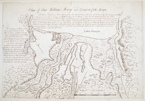
Plan of Fort William Henry and camp at Lake George
11860.
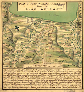
Plan of Fort William Henry and Camp at Lake George
‹ Prev
Next ›
1
2
…
589
590
591
592
593
594
595
596
597
…
669
670