Toggle navigation
LMEC Home
Exhibitions
Georeferencing
Tools for Teachers
Collections
My Favorites
Sign Up / Log In
Search
Search the map portal
Map Collection
Map Collection
Map Sets
Search
Search
Search for
Search In
All Fields
Creator
Title
Subject
Place
Search All Digital Collections
Advanced Search
13385 Results
Filter your Search
Place
North and Central America
9,353
United States
7,078
Suffolk (county)
1,664
Boston
1,621
Europe
1,035
Canada
949
Massachusetts
794
New York
532
more
Place
»
Topic
Boston (Mass.)--Maps
741
City planning--Massachusetts--Boston--Maps
418
United States--History--Revolution, 1775-1783--Maps
329
United States--Maps
315
Urban renewal--Massachusetts--Boston--Maps
254
Real property--Massachusetts--Boston--Maps
252
Massachusetts--Maps
219
Insurance surveys
197
more
Topic
»
Date
Date range begin
–
Date range end
Current results range from
1482
to
2023
View distribution
Creator
United States. Hydrographic Office
595
Boston Redevelopment Authority
403
Des Barres, Joseph F. W. (Joseph Frederick Wallet), 1722-1824
247
Royal United Services Institute for Defence and Security Studies
160
Jefferys, Thomas, -1771
154
George, III, King of Great Britain, 1738-1820
152
George, IV, King of Great Britain, 1762-1830
151
O.H. Bailey & Co
148
more
Creator
»
Format
Maps/Atlases
13,205
Manuscripts
985
Prints
102
Books
49
Drawings/Illustrations
44
Photographs
15
Objects/Artifacts
13
Documents
7
more
Format
»
Georeferenced
Yes
979
No
12,406
Collection
Norman B. Leventhal Map Center Collection
8,891
American Revolutionary War-Era Maps
3,305
Boston and New England Maps
2,804
Urban Maps
2,397
Maritime Charts and Atlases
1,150
William L. Clements Library Collection
910
Library of Congress Collection
618
Boston Redevelopment Authority Collection
475
more
Collection
»
Available to use
No known restrictions
9,952
Creative Commons license
1,677
Search Constraints
Sort by date (desc)
relevance
title
date (asc)
date (desc)
Number of results to display per page
20 per page
10
per page
20
per page
50
per page
100
per page
View results as:
grid view
map view
Search Results
11581.
An accurate map of the West Indies, containing the Bahama & Caribbe islands the Great & Little Antilles; with the Leward and...
11582.
An actual survey of the sea coast from New York to the I. Cape Briton : with tables of the direct and thwart courses &...
11583.
America Septentrionalis : concinnata juxta observationes Dnn Academiae Regalis Scientiarum et nonnullorum aliorum, et juxta...
11584.
British attack upon Ticonderoga, July 7 & 8, 1758
11585.
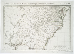
Carte de la Louisiane, Maryland, Virginie, Caroline, Georgie, avec une partie de la Floride
11586.
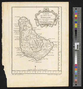
Carte de l'Isle de La Barbade : avec une description geographique de cette isle
11587.
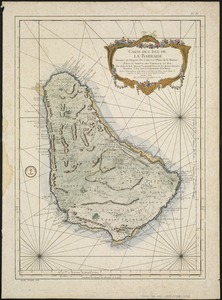
Carte de l'isle de la Barbade pour servir à l'histoire générale des voyages
11588.
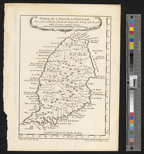
Carte de l'isle de la Grenade, pour servir à l'histoire générale des voyages
11589.
Carte Nouvellement Releve de La presantation a Frontenac : Nee Les Soude & moulliage cett Rivier Est for courant depuis Les...
11590.
Carte topographique du port et de la ville de Louisbourg, assiegé par les Anglais pendant les mois de Juin, Juillet 1758
11591.
A chart of the Atlantic Ocean : its islands and the adjacent continents: In which the British Dominions in Europe and America,...
11592.
A correct map of the coast of New England
11593.
COURS of ye ONONDAGA RIVER from ye three RIVERS to OSWEGO
11594.
The Course of the Wood Creek from the Mowhock River at the Onoida or Great Carrying Place to The Onoida Lake. Representing the...
11595.
Draught of the River Pittquioyack in the Bay of Fundy 1758
11596.
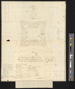
[Ein grund-riss von der Festung Duquessne wie sie ausgesehen hat, ehe sie die Frankosen zerstoren aben, und zum theil noch...
11597.
An exact ground plan of Fort Edward at Pesaquid taken from a survey and laid down by a scale of 60 feet to one inch
11598.
Fort at Carlisle
11599.
FORT AT IUNIATA
11600.
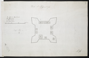
Fort at Shippensburgh
‹ Prev
Next ›
1
2
…
576
577
578
579
580
581
582
583
584
…
669
670


![[Ein grund-riss von der Festung Duquessne wie sie ausgesehen hat, ehe sie die Frankosen zerstoren aben, und zum theil noch aussiehet]](https://bpldcassets.blob.core.windows.net/derivatives/images/commonwealth:z603vv49q/image_thumbnail_300.jpg)