Toggle navigation
LMEC Home
Exhibitions
Georeferencing
Tools for Teachers
Collections
My Favorites
Sign Up / Log In
Search
Search the map portal
Map Collection
Map Collection
Map Sets
Search
Search
Search for
Search In
All Fields
Creator
Title
Subject
Place
Search All Digital Collections
Advanced Search
13385 Results
Filter your Search
Place
North and Central America
9,353
United States
7,078
Suffolk (county)
1,664
Boston
1,621
Europe
1,035
Canada
949
Massachusetts
794
New York
532
more
Place
»
Topic
Boston (Mass.)--Maps
741
City planning--Massachusetts--Boston--Maps
418
United States--History--Revolution, 1775-1783--Maps
329
United States--Maps
315
Urban renewal--Massachusetts--Boston--Maps
254
Real property--Massachusetts--Boston--Maps
252
Massachusetts--Maps
219
Insurance surveys
197
more
Topic
»
Date
Date range begin
–
Date range end
Current results range from
1482
to
2023
View distribution
Creator
United States. Hydrographic Office
595
Boston Redevelopment Authority
403
Des Barres, Joseph F. W. (Joseph Frederick Wallet), 1722-1824
247
Royal United Services Institute for Defence and Security Studies
160
Jefferys, Thomas, -1771
154
George, III, King of Great Britain, 1738-1820
152
George, IV, King of Great Britain, 1762-1830
151
O.H. Bailey & Co
148
more
Creator
»
Format
Maps/Atlases
13,205
Manuscripts
985
Prints
102
Books
49
Drawings/Illustrations
44
Photographs
15
Objects/Artifacts
13
Documents
7
more
Format
»
Georeferenced
Yes
979
No
12,406
Collection
Norman B. Leventhal Map Center Collection
8,891
American Revolutionary War-Era Maps
3,305
Boston and New England Maps
2,804
Urban Maps
2,397
Maritime Charts and Atlases
1,150
William L. Clements Library Collection
910
Library of Congress Collection
618
Boston Redevelopment Authority Collection
475
more
Collection
»
Available to use
No known restrictions
9,952
Creative Commons license
1,677
Search Constraints
Sort by relevance
relevance
title
date (asc)
date (desc)
Number of results to display per page
20 per page
10
per page
20
per page
50
per page
100
per page
View results as:
grid view
map view
Search Results
11521.
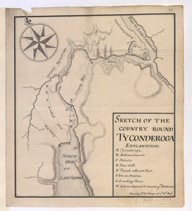
SKETCH OF THE COUNTRY ROUND TYCONDEROGA
11522.
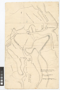
Sketch of the country round Tyconderoga
11523.
A sketch of the disposition of the force at New York for the defence of the port
11524.
A sketch of the east end of the peninsula where on is Hampton
11525.
Sketch of the engagement at Trenton : given on the 26th of December 1776 betwixt the American troops under command of General...
11526.
A sketch of the entrance from the sea to Apalachy and part of the environs
11527.
A sketch of the environs of Charlestown in South Carolina
11528.
A sketch of the environs of Charlestown in South Carolina
11529.
A sketch of the environs of Charlestown in South Carolina
11530.
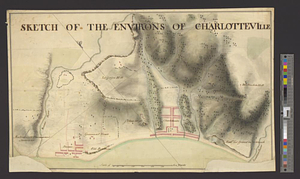
Sketch of the environs of Charlotteville
11531.
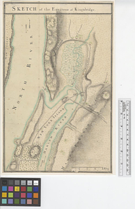
Sketch of the environs of King's bridge
11532.
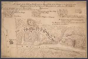
A sketch of the field of battle with the disposition of the troops in the beginning of the engagement of the 9th of July on the...
11533.
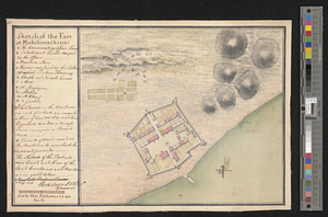
Sketch of the fort at Michilimackinac
11534.
Sketch of the ground about Charles Town
11535.
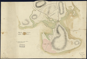
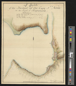
A sketch of the harbour at the Cape Slt: Nicola on the island of Hispaniola
11536.
Sketch of the harbour of Charles Town
11537.
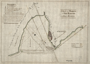
A Sketch of the harbour of Port Francoise on the Island of Hispaniola
11538.
A Sketch of the harbour of St. Iago de Cuba
11539.
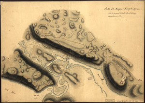
Sketch of the Heights of Kingsbridge 1777, with the proposed redoubts coloured orange : Old rebel works coloured black
11540.
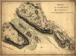
Sketch of the Heights of Kingsbridge, with the proposed redouts couloured yellow
‹ Prev
Next ›
1
2
…
573
574
575
576
577
578
579
580
581
…
669
670