Toggle navigation
LMEC Home
Exhibitions
Georeferencing
Tools for Teachers
Collections
My Favorites
Sign Up / Log In
Search
Search the map portal
Map Collection
Map Collection
Map Sets
Search
Search
Search for
Search In
All Fields
Creator
Title
Subject
Place
Search All Digital Collections
Advanced Search
13385 Results
Filter your Search
Place
North and Central America
9,353
United States
7,078
Suffolk (county)
1,664
Boston
1,621
Europe
1,035
Canada
949
Massachusetts
794
New York
532
more
Place
»
Topic
Boston (Mass.)--Maps
741
City planning--Massachusetts--Boston--Maps
418
United States--History--Revolution, 1775-1783--Maps
329
United States--Maps
315
Urban renewal--Massachusetts--Boston--Maps
254
Real property--Massachusetts--Boston--Maps
252
Massachusetts--Maps
219
Insurance surveys
197
more
Topic
»
Date
Date range begin
–
Date range end
Current results range from
1482
to
2023
View distribution
Creator
United States. Hydrographic Office
595
Boston Redevelopment Authority
403
Des Barres, Joseph F. W. (Joseph Frederick Wallet), 1722-1824
247
Royal United Services Institute for Defence and Security Studies
160
Jefferys, Thomas, -1771
154
George, III, King of Great Britain, 1738-1820
152
George, IV, King of Great Britain, 1762-1830
151
O.H. Bailey & Co
148
more
Creator
»
Format
Maps/Atlases
13,205
Manuscripts
985
Prints
102
Books
49
Drawings/Illustrations
44
Photographs
15
Objects/Artifacts
13
Documents
7
more
Format
»
Georeferenced
Yes
979
No
12,406
Collection
Norman B. Leventhal Map Center Collection
8,891
American Revolutionary War-Era Maps
3,305
Boston and New England Maps
2,804
Urban Maps
2,397
Maritime Charts and Atlases
1,150
William L. Clements Library Collection
910
Library of Congress Collection
618
Boston Redevelopment Authority Collection
475
more
Collection
»
Available to use
No known restrictions
9,952
Creative Commons license
1,677
Search Constraints
Sort by relevance
relevance
title
date (asc)
date (desc)
Number of results to display per page
20 per page
10
per page
20
per page
50
per page
100
per page
View results as:
grid view
map view
Search Results
11461.
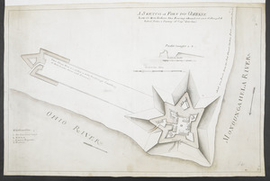
A SKETCH of FORT DU QUESNE how it was before the Enemy abandont and distryd it taken from a survey of Cap.t Gordon's
11462.
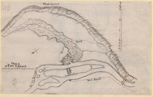
Sketch of Fort Edward and the proposed improvements
11463.
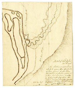
Sketch of Fort Edward, Novr. 30th, 1756
11464.
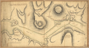
Sketch of Forts Clinton & Montgomery : stormed the 6th Octob. 1777 by the troops under the command of Sir Henry Clinton, K.B.,...
11465.
SKETCH of FORTS CLINTON & MONTGOMERY Stormed 6.th October 1777 by the Troops under the Command of Sir Henry Clinton K.B. L.t...
11466.
Sketch of forts Clinton and Montgomery stormed the 6th October 1777 by the troops under the command of Sr. Henry Clinton K:B:...
11467.
Sketch of Guadalupe Island : west coast of Lower California
11468.
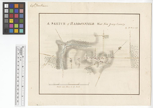
A sketch of Haddonfield : West New Jersey County
11469.
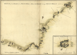
Sketch of Haddonfield, March 1778 : Sketch of the roads from Pennyhill to Black Horse through Mount Holly
11470.
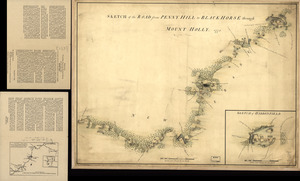
Sketch of Haddonfield. Sketch of the road from Penny Hill to Black Horse through Mount Holly, 1778
11471.
A sketch of Hallifax with its environs and the works, as executed in June 1776
11472.
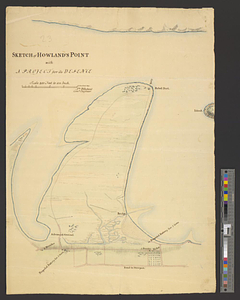
Sketch of Howland's Point with a project for its defence
11473.
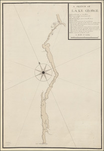
A SKETCH OF LAKE GEORGE
11474.
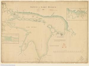
Sketch of Lake Huron
11475.
A Sketch of Lake Ontario between Oswego and Niagara and from thence up the River to the upper end of the Carrying place
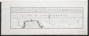
11476.
A SKETCH of LAKE ONTARO between OSWEGO and NIAGARA and from thence up the River to the upper End of the Carrying Place
11477.
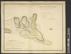
A sketch of Lloyd's Neck : particularly shewing the situation of the redoubt, encampment of the troops, with the ground...
11478.
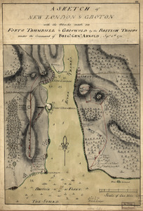
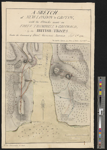
A sketch of New London & Groton with the attacks made on Forts Trumbull & Griswold by the British troops : under the command of...
11479.
Sketch of New York, narrows & part of Long Island with the roads
11480.
A sketch of New-London or Groton, with the attacks made on Forts Trumbull & Griswold by the British troops under the command of...
‹ Prev
Next ›
1
2
…
570
571
572
573
574
575
576
577
578
…
669
670