Toggle navigation
LMEC Home
Exhibitions
Georeferencing
Tools for Teachers
Collections
My Favorites
Sign Up / Log In
Search
Search the map portal
Map Collection
Map Collection
Map Sets
Search
Search
Search for
Search In
All Fields
Creator
Title
Subject
Place
Search All Digital Collections
Advanced Search
13385 Results
Filter your Search
Place
North and Central America
9,353
United States
7,078
Suffolk (county)
1,664
Boston
1,621
Europe
1,035
Canada
949
Massachusetts
794
New York
532
more
Place
»
Topic
Boston (Mass.)--Maps
741
City planning--Massachusetts--Boston--Maps
418
United States--History--Revolution, 1775-1783--Maps
329
United States--Maps
315
Urban renewal--Massachusetts--Boston--Maps
254
Real property--Massachusetts--Boston--Maps
252
Massachusetts--Maps
219
Insurance surveys
197
more
Topic
»
Date
Date range begin
–
Date range end
Current results range from
1482
to
2023
View distribution
Creator
United States. Hydrographic Office
595
Boston Redevelopment Authority
403
Des Barres, Joseph F. W. (Joseph Frederick Wallet), 1722-1824
247
Royal United Services Institute for Defence and Security Studies
160
Jefferys, Thomas, -1771
154
George, III, King of Great Britain, 1738-1820
152
George, IV, King of Great Britain, 1762-1830
151
O.H. Bailey & Co
148
more
Creator
»
Format
Maps/Atlases
13,205
Manuscripts
985
Prints
102
Books
49
Drawings/Illustrations
44
Photographs
15
Objects/Artifacts
13
Documents
7
more
Format
»
Georeferenced
Yes
979
No
12,406
Collection
Norman B. Leventhal Map Center Collection
8,891
American Revolutionary War-Era Maps
3,305
Boston and New England Maps
2,804
Urban Maps
2,397
Maritime Charts and Atlases
1,150
William L. Clements Library Collection
910
Library of Congress Collection
618
Boston Redevelopment Authority Collection
475
more
Collection
»
Available to use
No known restrictions
9,952
Creative Commons license
1,677
Search Constraints
Sort by relevance
relevance
title
date (asc)
date (desc)
Number of results to display per page
20 per page
10
per page
20
per page
50
per page
100
per page
View results as:
grid view
map view
Search Results
11421.
Siuslaw National Forest, Oregon
11422.
[Six sectional drawings of the Harbour of Saint John, Newfoundland]
11423.
Skecth [sic] of the road from Kings Bridge to White Plains
11424.
Skeleton map of rail-roads between Cape Canso and St. Louis
11425.
Skeleton map of the territory of the United States west of the Mississippi River : exhibiting the relations existing between...
11426.
Skeleton map showing the rail roads completed and in progress in the United States and their connection as proposed with the...
11427.
Skeleton plan, showing location of the Suffolk & Metropolitan rail road routes in Boston
11428.
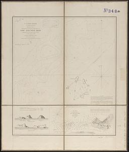
Sketch A No. 5 showing proposed site for a light house on Sow and Pigs Reef
11429.
Sketch A no. 5 showing proposed site for a light house on Sow and Pigs Reef
11430.
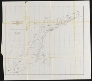
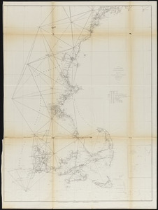
Sketch A, showing the primary triangulation in section I and the connection of the baselines in sections I and II
11431.
Sketch A showing the progress of the survey in Section No. 1 from 1844 to 1854
11432.
Sketch A showing the progress of the survey in section no. 1 from 1844 to 1881
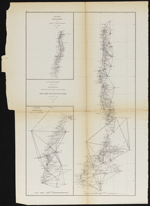
11433.
Sketch B.No.2 showing the progress of the survey in New York Bay & Hudson River from 1851 to 1859
11434.
Sketch from information of the different roads about Freehold in the Jerseys
11435.
Sketch from information of the different roads about Freehold in the Jerseys
11436.
Sketch map from the Dardanelles to the Bosphorus showing the positions of the British fleet
11437.
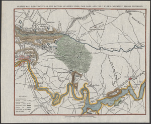
Sketch map, illustrative of Seven Pines, Fair Oaks, and the "Week's Campaign" before Richmond
11438.
[Sketch map of an unidentified fort]
11439.
Sketch map of Boston and the Public Library system
11440.
Sketch map of Boston and the Public Library system
‹ Prev
Next ›
1
2
…
568
569
570
571
572
573
574
575
576
…
669
670

![[Six sectional drawings of the Harbour of Saint John, Newfoundland]](https://bpldcassets.blob.core.windows.net/derivatives/images/commonwealth:6108vv37h/image_thumbnail_300.jpg)
![Skecth [sic] of the road from Kings Bridge to White Plains](https://bpldcassets.blob.core.windows.net/derivatives/images/commonwealth:q524n8895/image_thumbnail_300.jpg)


![[Sketch map of an unidentified fort]](https://bpldcassets.blob.core.windows.net/derivatives/images/commonwealth:hx11z101x/image_thumbnail_300.jpg)

