Toggle navigation
LMEC Home
Exhibitions
Georeferencing
Tools for Teachers
Collections
My Favorites
Sign Up / Log In
Search
Search the map portal
Map Collection
Map Collection
Map Sets
Search
Search
Search for
Search In
All Fields
Creator
Title
Subject
Place
Search All Digital Collections
Advanced Search
13385 Results
Filter your Search
Place
North and Central America
9,353
United States
7,078
Suffolk (county)
1,664
Boston
1,621
Europe
1,035
Canada
949
Massachusetts
794
New York
532
more
Place
»
Topic
Boston (Mass.)--Maps
741
City planning--Massachusetts--Boston--Maps
418
United States--History--Revolution, 1775-1783--Maps
329
United States--Maps
315
Urban renewal--Massachusetts--Boston--Maps
254
Real property--Massachusetts--Boston--Maps
252
Massachusetts--Maps
219
Insurance surveys
197
more
Topic
»
Date
Date range begin
–
Date range end
Current results range from
1482
to
2023
View distribution
Creator
United States. Hydrographic Office
595
Boston Redevelopment Authority
403
Des Barres, Joseph F. W. (Joseph Frederick Wallet), 1722-1824
247
Royal United Services Institute for Defence and Security Studies
160
Jefferys, Thomas, -1771
154
George, III, King of Great Britain, 1738-1820
152
George, IV, King of Great Britain, 1762-1830
151
O.H. Bailey & Co
148
more
Creator
»
Format
Maps/Atlases
13,205
Manuscripts
985
Prints
102
Books
49
Drawings/Illustrations
44
Photographs
15
Objects/Artifacts
13
Documents
7
more
Format
»
Georeferenced
Yes
979
No
12,406
Collection
Norman B. Leventhal Map Center Collection
8,891
American Revolutionary War-Era Maps
3,305
Boston and New England Maps
2,804
Urban Maps
2,397
Maritime Charts and Atlases
1,150
William L. Clements Library Collection
910
Library of Congress Collection
618
Boston Redevelopment Authority Collection
475
more
Collection
»
Available to use
No known restrictions
9,952
Creative Commons license
1,677
Search Constraints
Sort by relevance
relevance
title
date (asc)
date (desc)
Number of results to display per page
20 per page
10
per page
20
per page
50
per page
100
per page
View results as:
grid view
map view
Search Results
11321.
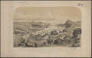
Sebastopol, and fortifications now in active progress on the land side
11322.
Second part of Asia : being China, part of India and Tartary, the islands of Sonda, Molucka, Philippin, Japan &c. ; performed...
11323.
The second section of the survey of 1819
11324.
Seconnet Passage
11325.
Sect: Düsseldorf
11326.
Section 16: Chemnitz
11327.
Section 16: Chemnitz
11328.
Section of a track chart of the world, covering the Behring Sea
11329.
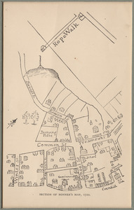
Section of Bonner's map
11330.
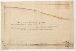
Section of the Citadel-Hill at Halifax : Showing the Progress made by the troops in leveling the same upon the line of 40 feet...
11331.
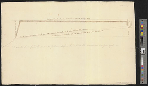
Section of the level of the country
11332.
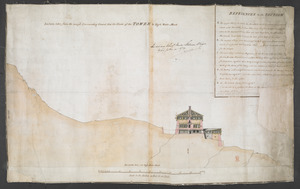
Section taken from the nearest Commanding Ground thro' the Center of the TOWER to High Water Mark
11333.
Sectional & topographical map of Holmes County, Ohio
11334.
A sectional map of Massachusetts, engraved expressly for Chapin's farm advertiser, 1871 : including the proposed Massachusetts...
11335.
Sectional map of the northern portion of Vancouver Island
11336.
Sectional map of the Old Colony Railroad South Shore, Nantasket Beach and Plymouth lines
11337.
Sections of soundings made by order of the Harbor Committee of 1852
11338.
Secunda Affrice tabula continet Affricam & insulae que circa ipsam sunt
11339.
Secunda Africae tabula
11340.
Secunda Asiae tabula
‹ Prev
Next ›
1
2
…
563
564
565
566
567
568
569
570
571
…
669
670