Toggle navigation
LMEC Home
Exhibitions
Georeferencing
Tools for Teachers
Collections
My Favorites
Sign Up / Log In
Search
Search the map portal
Map Collection
Map Collection
Map Sets
Search
Search
Search for
Search In
All Fields
Creator
Title
Subject
Place
Search All Digital Collections
Advanced Search
13385 Results
Filter your Search
Place
North and Central America
9,353
United States
7,078
Suffolk (county)
1,664
Boston
1,621
Europe
1,035
Canada
949
Massachusetts
794
New York
532
more
Place
»
Topic
Boston (Mass.)--Maps
741
City planning--Massachusetts--Boston--Maps
418
United States--History--Revolution, 1775-1783--Maps
329
United States--Maps
315
Urban renewal--Massachusetts--Boston--Maps
254
Real property--Massachusetts--Boston--Maps
252
Massachusetts--Maps
219
Insurance surveys
197
more
Topic
»
Date
Date range begin
–
Date range end
Current results range from
1482
to
2023
View distribution
Creator
United States. Hydrographic Office
595
Boston Redevelopment Authority
403
Des Barres, Joseph F. W. (Joseph Frederick Wallet), 1722-1824
247
Royal United Services Institute for Defence and Security Studies
160
Jefferys, Thomas, -1771
154
George, III, King of Great Britain, 1738-1820
152
George, IV, King of Great Britain, 1762-1830
151
O.H. Bailey & Co
148
more
Creator
»
Format
Maps/Atlases
13,205
Manuscripts
985
Prints
102
Books
49
Drawings/Illustrations
44
Photographs
15
Objects/Artifacts
13
Documents
7
more
Format
»
Georeferenced
Yes
979
No
12,406
Collection
Norman B. Leventhal Map Center Collection
8,891
American Revolutionary War-Era Maps
3,305
Boston and New England Maps
2,804
Urban Maps
2,397
Maritime Charts and Atlases
1,150
William L. Clements Library Collection
910
Library of Congress Collection
618
Boston Redevelopment Authority Collection
475
more
Collection
»
Available to use
No known restrictions
9,952
Creative Commons license
1,677
Search Constraints
Sort by date (desc)
relevance
title
date (asc)
date (desc)
Number of results to display per page
20 per page
10
per page
20
per page
50
per page
100
per page
View results as:
grid view
map view
Search Results
11241.
Porti della Nuova York e Perthamboy
11242.
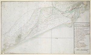
SCETCH of the CITY and Environs of S.T AUGUSTINE
11243.
Scetch [sic] of the blockhouse at the east of Oneda Lake
11244.
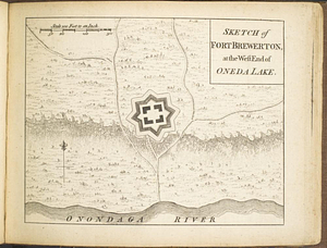
Sketch of Fort Brewerton at the west end of Oneda Lake
11245.
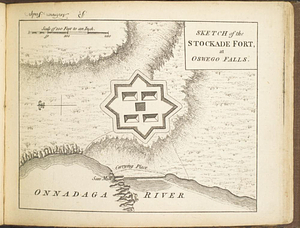
Sketch of the stockade fort, at Oswego Falls
11246.
A south east view of the city of New York, in North America = Vue de sud est de la ville de New York, dans l'Amerique...
11247.
A south west view of the city of New York, in North America = Vue de sud ouest de la ville de New York, dans l'Amerique...
11248.
Theodolite's pattern, shewing the provinces in North America which were in the respective possessions of England, France &...
11249.
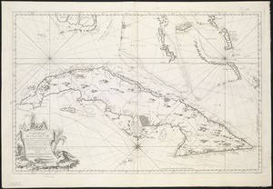
An accurate map of Cuba, and the adjacent islands
11250.
An accurate map of the British Empire in Nth. America as settled by the preliminaries in 1762
11251.
An accurate map of the British empire in Nth. America as settled by the preliminaries in 1762
11252.
An accurate map of the British, French & Spanish settlements in Nth. America and the West Indies : as stipulated by the...
11253.
An Accurate map of the West Indies, with the adjacent coast
11254.
America
11255.
L'Amerique divisée par grand etats
11256.
L'Amerique meridionale divisée en ses principaux etats
11257.
L'Amérique Septentrionale divisée en ses principaux états
11258.
Carte geo-hydrographique du Golfe du Mexique et de ces isles : construit d'après les mémoires les plus recens, et assujeties...
11259.
Carte hydrographique de la baye de la Havane : avec le plan de la ville et de ses forts pour joindre a la Carte de l'isle de Cube
11260.
Carte réduite de l'isle de Cube
‹ Prev
Next ›
1
2
…
559
560
561
562
563
564
565
566
567
…
669
670

![Scetch [sic] of the blockhouse at the east of Oneda Lake](https://bpldcassets.blob.core.windows.net/derivatives/metadata/commonwealth-oai:zs2626251/image_thumbnail_300.jpg)