Toggle navigation
LMEC Home
Exhibitions
Georeferencing
Tools for Teachers
Collections
My Favorites
Sign Up / Log In
Search
Search the map portal
Map Collection
Map Collection
Map Sets
Search
Search
Search for
Search In
All Fields
Creator
Title
Subject
Place
Search All Digital Collections
Advanced Search
13385 Results
Filter your Search
Place
North and Central America
9,353
United States
7,078
Suffolk (county)
1,664
Boston
1,621
Europe
1,035
Canada
949
Massachusetts
794
New York
532
more
Place
»
Topic
Boston (Mass.)--Maps
741
City planning--Massachusetts--Boston--Maps
418
United States--History--Revolution, 1775-1783--Maps
329
United States--Maps
315
Urban renewal--Massachusetts--Boston--Maps
254
Real property--Massachusetts--Boston--Maps
252
Massachusetts--Maps
219
Insurance surveys
197
more
Topic
»
Date
Date range begin
–
Date range end
Current results range from
1482
to
2023
View distribution
Creator
United States. Hydrographic Office
595
Boston Redevelopment Authority
403
Des Barres, Joseph F. W. (Joseph Frederick Wallet), 1722-1824
247
Royal United Services Institute for Defence and Security Studies
160
Jefferys, Thomas, -1771
154
George, III, King of Great Britain, 1738-1820
152
George, IV, King of Great Britain, 1762-1830
151
O.H. Bailey & Co
148
more
Creator
»
Format
Maps/Atlases
13,205
Manuscripts
985
Prints
102
Books
49
Drawings/Illustrations
44
Photographs
15
Objects/Artifacts
13
Documents
7
more
Format
»
Georeferenced
Yes
979
No
12,406
Collection
Norman B. Leventhal Map Center Collection
8,891
American Revolutionary War-Era Maps
3,305
Boston and New England Maps
2,804
Urban Maps
2,397
Maritime Charts and Atlases
1,150
William L. Clements Library Collection
910
Library of Congress Collection
618
Boston Redevelopment Authority Collection
475
more
Collection
»
Available to use
No known restrictions
9,952
Creative Commons license
1,677
Search Constraints
Sort by date (asc)
relevance
title
date (asc)
date (desc)
Number of results to display per page
20 per page
10
per page
20
per page
50
per page
100
per page
View results as:
grid view
map view
Search Results
11141.
Atlas of the towns of Needham, Dover, Westwood, Millis and Medfield, Norfolk County, Massachusetts : from official plans and...
11142.
Birds eye view showing Portland R.R. Co. system and connecting lines
11143.
Boston Globe Newsboys on Newspaper Row
11144.
Boy Peddling Notions, Downtown Boston
11145.
Buzzards Bay, Mass
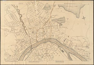
11146.
City of Brockton
11147.
City of Butte : indexed map showing Butte and vicinity with location of mines, schools, public buildings, streets, etc
11148.
City of Haverhill, Massachusetts
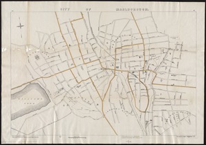
11149.
City of Marlborough
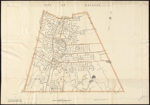
11150.
City of Melrose
11151.
A geological map of Ohio
11152.
Der Hafen von Hamburg
11153.
Index diagram of sheets for the International map on the scale of 1:1,000,000
11154.
Map eleventh division railway mail service
11155.
Map of Boston : Dec. 1, 1908
11156.
Map of Boston and suburbs
11157.
Map of Cape Cod and vicinity
11158.
Map of Fort Leavenworth, Kansas and vicinity
11159.
Map of Greenwich, township and borough, Fairfield County, Connecticut
11160.
Map of maneuver ground, Massachusetts, 1909
‹ Prev
Next ›
1
2
…
554
555
556
557
558
559
560
561
562
…
669
670