Toggle navigation
LMEC Home
Exhibitions
Georeferencing
Tools for Teachers
Collections
My Favorites
Sign Up / Log In
Search
Search the map portal
Map Collection
Map Collection
Map Sets
Search
Search
Search for
Search In
All Fields
Creator
Title
Subject
Place
Search All Digital Collections
Advanced Search
13385 Results
Filter your Search
Place
North and Central America
9,353
United States
7,078
Suffolk (county)
1,664
Boston
1,621
Europe
1,035
Canada
949
Massachusetts
794
New York
532
more
Place
»
Topic
Boston (Mass.)--Maps
741
City planning--Massachusetts--Boston--Maps
418
United States--History--Revolution, 1775-1783--Maps
329
United States--Maps
315
Urban renewal--Massachusetts--Boston--Maps
254
Real property--Massachusetts--Boston--Maps
252
Massachusetts--Maps
219
Insurance surveys
197
more
Topic
»
Date
Date range begin
–
Date range end
Current results range from
1482
to
2023
View distribution
Creator
United States. Hydrographic Office
595
Boston Redevelopment Authority
403
Des Barres, Joseph F. W. (Joseph Frederick Wallet), 1722-1824
247
Royal United Services Institute for Defence and Security Studies
160
Jefferys, Thomas, -1771
154
George, III, King of Great Britain, 1738-1820
152
George, IV, King of Great Britain, 1762-1830
151
O.H. Bailey & Co
148
more
Creator
»
Format
Maps/Atlases
13,205
Manuscripts
985
Prints
102
Books
49
Drawings/Illustrations
44
Photographs
15
Objects/Artifacts
13
Documents
7
more
Format
»
Georeferenced
Yes
979
No
12,406
Collection
Norman B. Leventhal Map Center Collection
8,891
American Revolutionary War-Era Maps
3,305
Boston and New England Maps
2,804
Urban Maps
2,397
Maritime Charts and Atlases
1,150
William L. Clements Library Collection
910
Library of Congress Collection
618
Boston Redevelopment Authority Collection
475
more
Collection
»
Available to use
No known restrictions
9,952
Creative Commons license
1,677
Search Constraints
Sort by relevance
relevance
title
date (asc)
date (desc)
Number of results to display per page
20 per page
10
per page
20
per page
50
per page
100
per page
View results as:
grid view
map view
Search Results
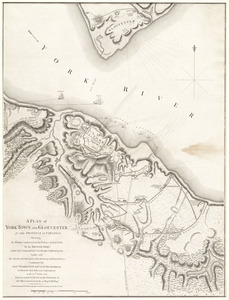
10261.
A plan of York Town and Gloucester, in the province of Virginia, shewing the works constructed for the defence of those posts...
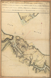
10262.
Plan of York Town and Gloucester in Virginia : shewing the works constructed for the defence of those posts by the Rt. Honble:...
10263.
Plan of Zisapata Bay ; Plan of the harbour of Carthagena
10264.
Plan or map showing the laying out of Rail Road Street
10265.
Plan pittoresque de la ville de Paris
10266.
Plan presented to the honble. the State Commissioners for the improvement of the Back Bay
10267.
Plan resurvey'd for Jonathan Robinson all that his plantation by Raritan River containing 772 acres and the usual allowance for...
10268.
Plan. Road from Tatnic to Groundroothl
10269.
Plan routier de la ville de Paris et de ses faubourgs : ou se trouvent indiqués tous les Changemens opérés jusqu'a ce jour...
10270.
Plan routier de la ville et fauxbourgs de Paris divisé en douze mairiea
10271.
A plan shewing the situation & construction for a seat of government on the Mississippi
10272.
Plan showing approximate location of Eastern Avenue : Sept. 18th 1861
10273.
Plan showing encroachments upon the inner basins of Boston Harbor : accompanying annual report of Harbor and Land...
10274.
Plan showing proposed method of introducing the water of Mystic Pond into Charlestown
10275.
Plan showing proposed route of Subway, February 1895
10276.
Plan showing the locality of the formation and the route of the procession of Knights Templar, August 27, 1895 : issued for the...
10277.
Plan showing the part of Stoneham which the petitioners desire to have annexed to Wakefield
10278.
Plan showing the principal portion of Boston : from the latest authorities
10279.
Plan showing the principal portion of Boston : from the oldest authorities
10280.
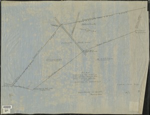
[Plan showing wharves of Boston from Batterymarch Street to Fleet Street; the "circular line" limit of wharves; and the...
‹ Prev
Next ›
1
2
…
510
511
512
513
514
515
516
517
518
…
669
670


![[Plan showing wharves of Boston from Batterymarch Street to Fleet Street; the "circular line" limit of wharves; and the Barricado, with gaps]](https://bpldcassets.blob.core.windows.net/derivatives/images/commonwealth:9s161j18r/image_thumbnail_300.jpg)