Toggle navigation
LMEC Home
Exhibitions
Georeferencing
Tools for Teachers
Collections
My Favorites
Sign Up / Log In
Search
Search the map portal
Map Collection
Map Collection
Map Sets
Search
Search
Search for
Search In
All Fields
Creator
Title
Subject
Place
Search All Digital Collections
Advanced Search
13385 Results
Filter your Search
Place
North and Central America
9,353
United States
7,078
Suffolk (county)
1,664
Boston
1,621
Europe
1,035
Canada
949
Massachusetts
794
New York
532
more
Place
»
Topic
Boston (Mass.)--Maps
741
City planning--Massachusetts--Boston--Maps
418
United States--History--Revolution, 1775-1783--Maps
329
United States--Maps
315
Urban renewal--Massachusetts--Boston--Maps
254
Real property--Massachusetts--Boston--Maps
252
Massachusetts--Maps
219
Insurance surveys
197
more
Topic
»
Date
Date range begin
–
Date range end
Current results range from
1482
to
2023
View distribution
Creator
United States. Hydrographic Office
595
Boston Redevelopment Authority
403
Des Barres, Joseph F. W. (Joseph Frederick Wallet), 1722-1824
247
Royal United Services Institute for Defence and Security Studies
160
Jefferys, Thomas, -1771
154
George, III, King of Great Britain, 1738-1820
152
George, IV, King of Great Britain, 1762-1830
151
O.H. Bailey & Co
148
more
Creator
»
Format
Maps/Atlases
13,205
Manuscripts
985
Prints
102
Books
49
Drawings/Illustrations
44
Photographs
15
Objects/Artifacts
13
Documents
7
more
Format
»
Georeferenced
Yes
979
No
12,406
Collection
Norman B. Leventhal Map Center Collection
8,891
American Revolutionary War-Era Maps
3,305
Boston and New England Maps
2,804
Urban Maps
2,397
Maritime Charts and Atlases
1,150
William L. Clements Library Collection
910
Library of Congress Collection
618
Boston Redevelopment Authority Collection
475
more
Collection
»
Available to use
No known restrictions
9,952
Creative Commons license
1,677
Search Constraints
Sort by date (asc)
relevance
title
date (asc)
date (desc)
Number of results to display per page
20 per page
10
per page
20
per page
50
per page
100
per page
View results as:
grid view
map view
Search Results
9601.
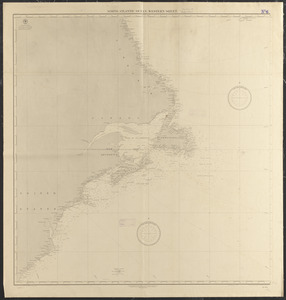
North Atlantic Ocean
9602.
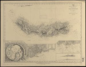
North Atlantic--Azores, San Miguel : from a British survey in 1844
9603.
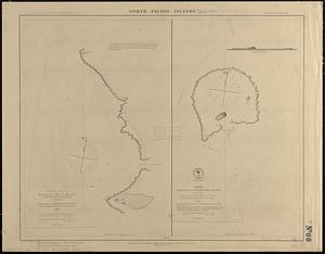
North Pacific islands
9604.
North Pacific Ocean
9605.
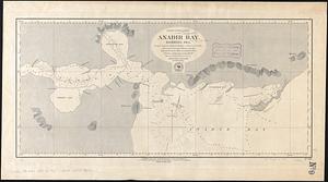
North Pacific Ocean, Anadir Bay, Behring Sea : from a chart by Engineer Bulkley of New York in 1865, with corrections and...
9606.
North Pacific Ocean, west coast of North America between latitudes 51° 30' and 55° 30' N. embracing the Queen Charlotte...
9607.
North Pacific Ocean, west coast of North America from the Juan de Fuca Strait to Queen Charlotte Is. including Vancouver Island...
9608.
North Pacific, the Sandwich Islands, with islands and reefs to the westward
9609.
Nova Scotia, Canso Harbor : from a British survey in 1850-55
9610.
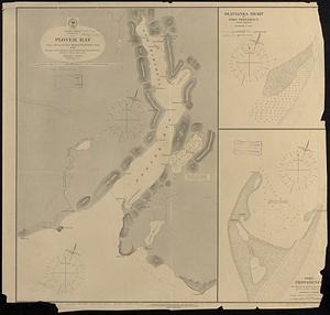
Pacific Ocean, Behrings Sea, Plover Bay : from a survey by Lieut. Maximov Imp! Russian Navy, 1876
9611.
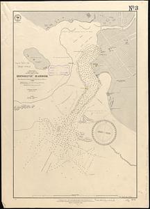
Pacific Ocean, Sandwich Islands, south coast of Oahu, Honolulu Harbor : from surveys by British and United States officers to 1888
9612.
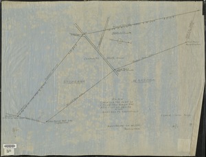
Plan showing the part of Stoneham which the petitioners desire to have annexed to Wakefield
9613.
Political map of California. 1888
9614.
Political map of Connecticut 1888 ; Political map of New York 1888
9615.
Political map of Indiana. 1888
9616.
Political map of Michigan 1888
9617.
Political map of New Jersey 1888
9618.
Political map of the United States and territories. 1888
9619.
Political map of West Virginia 1888
9620.
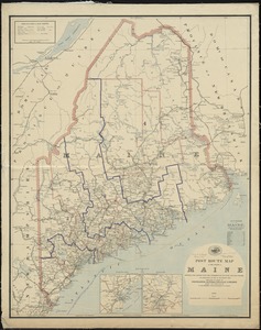
Post route map of the State of Maine showing post offices with the intermediate distances and mail routes in operation on the...
‹ Prev
Next ›
1
2
…
477
478
479
480
481
482
483
484
485
…
669
670