Toggle navigation
LMEC Home
Exhibitions
Georeferencing
Tools for Teachers
Collections
My Favorites
Sign Up / Log In
Search
Search the map portal
Map Collection
Map Collection
Map Sets
Search
Search
Search for
Search In
All Fields
Creator
Title
Subject
Place
Search All Digital Collections
Advanced Search
13385 Results
Filter your Search
Place
North and Central America
9,353
United States
7,078
Suffolk (county)
1,664
Boston
1,621
Europe
1,035
Canada
949
Massachusetts
794
New York
532
more
Place
»
Topic
Boston (Mass.)--Maps
741
City planning--Massachusetts--Boston--Maps
418
United States--History--Revolution, 1775-1783--Maps
329
United States--Maps
315
Urban renewal--Massachusetts--Boston--Maps
254
Real property--Massachusetts--Boston--Maps
252
Massachusetts--Maps
219
Insurance surveys
197
more
Topic
»
Date
Date range begin
–
Date range end
Current results range from
1482
to
2023
View distribution
Creator
United States. Hydrographic Office
595
Boston Redevelopment Authority
403
Des Barres, Joseph F. W. (Joseph Frederick Wallet), 1722-1824
247
Royal United Services Institute for Defence and Security Studies
160
Jefferys, Thomas, -1771
154
George, III, King of Great Britain, 1738-1820
152
George, IV, King of Great Britain, 1762-1830
151
O.H. Bailey & Co
148
more
Creator
»
Format
Maps/Atlases
13,205
Manuscripts
985
Prints
102
Books
49
Drawings/Illustrations
44
Photographs
15
Objects/Artifacts
13
Documents
7
more
Format
»
Georeferenced
Yes
979
No
12,406
Collection
Norman B. Leventhal Map Center Collection
8,891
American Revolutionary War-Era Maps
3,305
Boston and New England Maps
2,804
Urban Maps
2,397
Maritime Charts and Atlases
1,150
William L. Clements Library Collection
910
Library of Congress Collection
618
Boston Redevelopment Authority Collection
475
more
Collection
»
Available to use
No known restrictions
9,952
Creative Commons license
1,677
Search Constraints
Sort by date (desc)
relevance
title
date (asc)
date (desc)
Number of results to display per page
20 per page
10
per page
20
per page
50
per page
100
per page
View results as:
grid view
map view
Search Results
9541.
An accurate map of Rhode Island, part of Connecticut and Massachusets, shewing Admiral Arbuthnot's station in blocking up...
9542.
An accurate map of Rhode Island, part of Connecticut and Massachusets, shewing Admiral Arbuthnot's station in blocking up...
9543.
Afrique
9544.
Amérique septentrionale
9545.
Boston
9546.
Boston
9547.
Boston et ses environs
9548.
Carte de la Louisiane et de la Floride
9549.
[Carte de la rivière et de la colonie Demerari jusqu'à Mahayka Creek]
9550.
Carte de l'entrée du port et rade de Pensacola
9551.
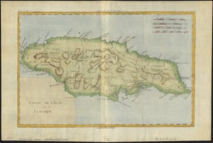
Carte de l'isle de la Jamaïque
9552.
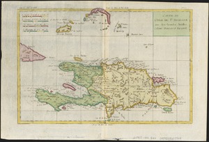
Carte de L'Isle de St. Domingue une des Grandes Antilles, Colonies Francoise et Espagnole
9553.
Carte du Golphe du Mexique et des isles Antilles : reduite de la grande carte angloise de Popple
9554.
Carte particuliere du havre de Boston : avec les sondes les bancs de Sable, les rochers les Amaies et les autres directions...
9555.
Carte particuliere du havre de Boston : avec les sondes les bancs de Sable, les rochers les Amaies et les autres directions...
9556.
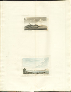
Castle William : A view of New Castle with the Fort and light house on the entrance of the Pisquataqua River
9557.
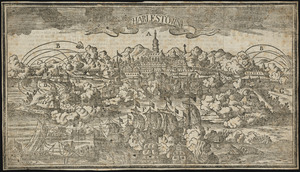
Charlestown
9558.
A chart of Montego Bay on the north west shore of the island of Jamaica : Port Antonio on the north east shore of the island of...
9559.
A chart of Nova Scotia
9560.
A chart of the bay and harbour of Pensacola in the Province of West Florida
‹ Prev
Next ›
1
2
…
474
475
476
477
478
479
480
481
482
…
669
670


![[Carte de la rivière et de la colonie Demerari jusqu'à Mahayka Creek]](https://bpldcassets.blob.core.windows.net/derivatives/images/commonwealth:w9505s514/image_thumbnail_300.jpg)