Toggle navigation
LMEC Home
Exhibitions
Georeferencing
Tools for Teachers
Collections
My Favorites
Sign Up / Log In
Search
Search the map portal
Map Collection
Map Collection
Map Sets
Search
Search
Search for
Search In
All Fields
Creator
Title
Subject
Place
Search All Digital Collections
Advanced Search
13385 Results
Filter your Search
Place
North and Central America
9,353
United States
7,078
Suffolk (county)
1,664
Boston
1,621
Europe
1,035
Canada
949
Massachusetts
794
New York
532
more
Place
»
Topic
Boston (Mass.)--Maps
741
City planning--Massachusetts--Boston--Maps
418
United States--History--Revolution, 1775-1783--Maps
329
United States--Maps
315
Urban renewal--Massachusetts--Boston--Maps
254
Real property--Massachusetts--Boston--Maps
252
Massachusetts--Maps
219
Insurance surveys
197
more
Topic
»
Date
Date range begin
–
Date range end
Current results range from
1482
to
2023
View distribution
Creator
United States. Hydrographic Office
595
Boston Redevelopment Authority
403
Des Barres, Joseph F. W. (Joseph Frederick Wallet), 1722-1824
247
Royal United Services Institute for Defence and Security Studies
160
Jefferys, Thomas, -1771
154
George, III, King of Great Britain, 1738-1820
152
George, IV, King of Great Britain, 1762-1830
151
O.H. Bailey & Co
148
more
Creator
»
Format
Maps/Atlases
13,205
Manuscripts
985
Prints
102
Books
49
Drawings/Illustrations
44
Photographs
15
Objects/Artifacts
13
Documents
7
more
Format
»
Georeferenced
Yes
979
No
12,406
Collection
Norman B. Leventhal Map Center Collection
8,891
American Revolutionary War-Era Maps
3,305
Boston and New England Maps
2,804
Urban Maps
2,397
Maritime Charts and Atlases
1,150
William L. Clements Library Collection
910
Library of Congress Collection
618
Boston Redevelopment Authority Collection
475
more
Collection
»
Available to use
No known restrictions
9,952
Creative Commons license
1,677
Search Constraints
Sort by date (desc)
relevance
title
date (asc)
date (desc)
Number of results to display per page
20 per page
10
per page
20
per page
50
per page
100
per page
View results as:
grid view
map view
Search Results
9481.
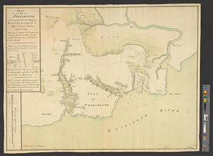
Plan of the post of Portsmouth as it is occupied by his majesty's forces under the command of Major General Phillips, April...
9482.
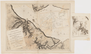
A plan of the posts of York and Gloucester in the province of Virginia, established by His Majesty's army under the command of...
9483.
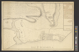
Plan of the siege of Fort George and works adjacent at Pensacola in West Florida, 1781
9484.
Plan of the town of Boston, with the attack on Bunkers-Hill, in the peninsula of Charlestown, the 17th of June, 1775
9485.
A plan of the town of Newport in the province of Rhode Island
9486.
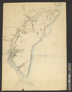
Plan of West Point, Virginia
9487.
Plan of Wilmington in the province of Nth: Carolina
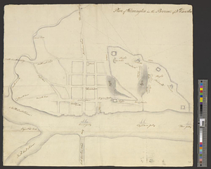
9488.
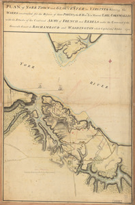
Plan of York Town and Gloucester in Virginia : shewing the works constructed for the defence of those posts by the Rt. Honble:...
9489.
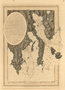
Port Amherst ; Port Haldimand
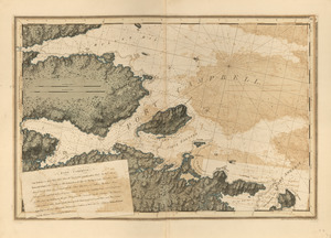
9490.
Port Amherst ; Port Haldimand
9491.
Port Campbell
9492.
Port Jackson
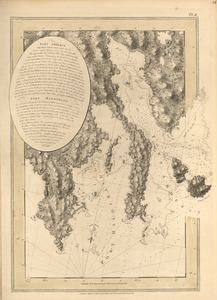
9493.
Port Mills : Port Mansfield ; Gambier Harbour
9494.
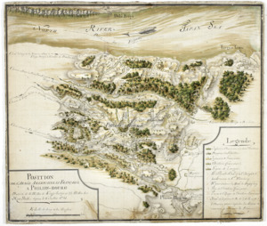
Position de 'larmee Américane et Française a Philips-bourg : distante de 12 milles de Kings-bridge et 25 milles de New-York,...
9495.
Position du camp de l'armée combinée a Philipsburg du 6 juillet au 19 aoust
9496.
Position of the troops under Earl Cornwallis on the 28 and 29th September 1781; when the enemy first appeared
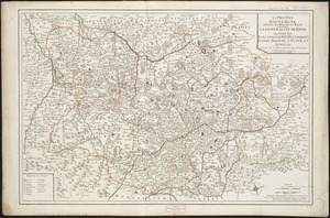
9497.
La province d'Auvergne divisée en haute et basse : la generalité de Riom ou sont les elections de Riom, Clermont, Issoire,...
9498.
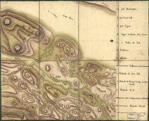
Reconnoissance de King's bridge : I
9499.
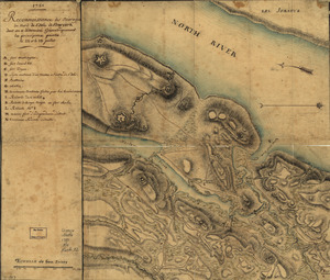
Reconnoissance des ouvrages du nord de l'Isle de Newyork dont on a déterminé géometriquement les principaux points le 22 et...
9500.
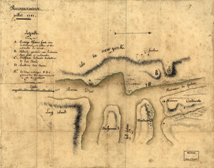
Reconnoissance, juillet 1781
‹ Prev
Next ›
1
2
…
471
472
473
474
475
476
477
478
479
…
669
670