Toggle navigation
LMEC Home
Exhibitions
Georeferencing
Tools for Teachers
Collections
My Favorites
Sign Up / Log In
Search
Search the map portal
Map Collection
Map Collection
Map Sets
Search
Search
Search for
Search In
All Fields
Creator
Title
Subject
Place
Search All Digital Collections
Advanced Search
13385 Results
Filter your Search
Place
North and Central America
9,353
United States
7,078
Suffolk (county)
1,664
Boston
1,621
Europe
1,035
Canada
949
Massachusetts
794
New York
532
more
Place
»
Topic
Boston (Mass.)--Maps
741
City planning--Massachusetts--Boston--Maps
418
United States--History--Revolution, 1775-1783--Maps
329
United States--Maps
315
Urban renewal--Massachusetts--Boston--Maps
254
Real property--Massachusetts--Boston--Maps
252
Massachusetts--Maps
219
Insurance surveys
197
more
Topic
»
Date
Date range begin
–
Date range end
Current results range from
1482
to
2023
View distribution
Creator
United States. Hydrographic Office
595
Boston Redevelopment Authority
403
Des Barres, Joseph F. W. (Joseph Frederick Wallet), 1722-1824
247
Royal United Services Institute for Defence and Security Studies
160
Jefferys, Thomas, -1771
154
George, III, King of Great Britain, 1738-1820
152
George, IV, King of Great Britain, 1762-1830
151
O.H. Bailey & Co
148
more
Creator
»
Format
Maps/Atlases
13,205
Manuscripts
985
Prints
102
Books
49
Drawings/Illustrations
44
Photographs
15
Objects/Artifacts
13
Documents
7
more
Format
»
Georeferenced
Yes
979
No
12,406
Collection
Norman B. Leventhal Map Center Collection
8,891
American Revolutionary War-Era Maps
3,305
Boston and New England Maps
2,804
Urban Maps
2,397
Maritime Charts and Atlases
1,150
William L. Clements Library Collection
910
Library of Congress Collection
618
Boston Redevelopment Authority Collection
475
more
Collection
»
Available to use
No known restrictions
9,952
Creative Commons license
1,677
Search Constraints
Sort by date (desc)
relevance
title
date (asc)
date (desc)
Number of results to display per page
20 per page
10
per page
20
per page
50
per page
100
per page
View results as:
grid view
map view
Search Results
9341.
3:d Position
9342.
4:th Position
9343.
An Accurate map of New Hampshire in New England, from a late survey
9344.
Amérique Septentrionale, Yorck : reconnoissance des ouvrages de cette ville ave le tracé des attaques dirigées contre eux
9345.
Annapolis Royal
9346.
Annapolis Royal ; St. Mary's Bay
9347.
Appearance of the land from the White Islands to St. Marys River taken two leagues off shore : The entrance of Milford Haven at...
9348.
The archipelago of the East, being the Sunda, the Molucca, and Phillipps. Islands : the chief settlements of the Dutch in India...
9349.
Atlantic Neptune [front matter]
9350.
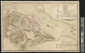
Attaque de la ville d'York en Virginie prise le 19 8bre 1781 par les armées combinées de France et d'Amérique
9351.
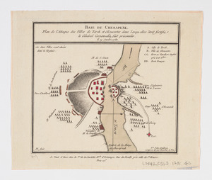
Baie de Chesapeak : plan de l'attaque des villes de Yorck et Gloucester dans lesquelles êtoit fortifie le Général Cornwalia,...
9352.
Barrington Bay
9353.
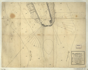
Batteries de West-point au haut de la Rivière d'York
9354.
Battle of Guildford fought on the 15 of March 1781
9355.
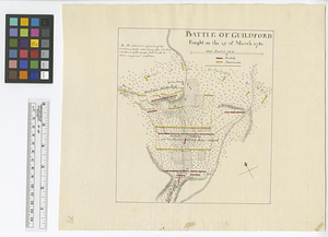
Battle of Guildford fought on the 15 of March 1781
9356.
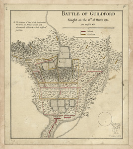
Battle of Guildford fought on the 15th of March 1781
9357.
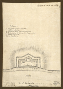
Bay of Pensacola, fortification
9358.
British troop dispositions in and near New York City
9359.
British troop dispositions in and near New York City, July and August 1781
9360.
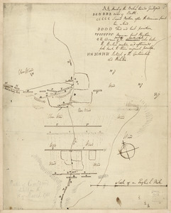
The British works at Yorktown and Gloucester
‹ Prev
Next ›
1
2
…
464
465
466
467
468
469
470
471
472
…
669
670


![Atlantic Neptune [front matter]](https://bpldcassets.blob.core.windows.net/derivatives/images/commonwealth:3f462x58k/image_thumbnail_300.jpg)