Toggle navigation
LMEC Home
Exhibitions
Georeferencing
Tools for Teachers
Collections
My Favorites
Sign Up / Log In
Search
Search the map portal
Map Collection
Map Collection
Map Sets
Search
Search
Search for
Search In
All Fields
Creator
Title
Subject
Place
Search All Digital Collections
Advanced Search
13385 Results
Filter your Search
Place
North and Central America
9,353
United States
7,078
Suffolk (county)
1,664
Boston
1,621
Europe
1,035
Canada
949
Massachusetts
794
New York
532
more
Place
»
Topic
Boston (Mass.)--Maps
741
City planning--Massachusetts--Boston--Maps
418
United States--History--Revolution, 1775-1783--Maps
329
United States--Maps
315
Urban renewal--Massachusetts--Boston--Maps
254
Real property--Massachusetts--Boston--Maps
252
Massachusetts--Maps
219
Insurance surveys
197
more
Topic
»
Date
Date range begin
–
Date range end
Current results range from
1482
to
2023
View distribution
Creator
United States. Hydrographic Office
595
Boston Redevelopment Authority
403
Des Barres, Joseph F. W. (Joseph Frederick Wallet), 1722-1824
247
Royal United Services Institute for Defence and Security Studies
160
Jefferys, Thomas, -1771
154
George, III, King of Great Britain, 1738-1820
152
George, IV, King of Great Britain, 1762-1830
151
O.H. Bailey & Co
148
more
Creator
»
Format
Maps/Atlases
13,205
Manuscripts
985
Prints
102
Books
49
Drawings/Illustrations
44
Photographs
15
Objects/Artifacts
13
Documents
7
more
Format
»
Georeferenced
Yes
979
No
12,406
Collection
Norman B. Leventhal Map Center Collection
8,891
American Revolutionary War-Era Maps
3,305
Boston and New England Maps
2,804
Urban Maps
2,397
Maritime Charts and Atlases
1,150
William L. Clements Library Collection
910
Library of Congress Collection
618
Boston Redevelopment Authority Collection
475
more
Collection
»
Available to use
No known restrictions
9,952
Creative Commons license
1,677
Search Constraints
Sort by relevance
relevance
title
date (asc)
date (desc)
Number of results to display per page
20 per page
10
per page
20
per page
50
per page
100
per page
View results as:
grid view
map view
Search Results
7261.
Nieuwe en perfeckte caerte van Engelandt Schotlandt en Yerlandt nieuwelyck vyt gegeven
7262.
Nieuwe en zeer accuraate generaale caart van de twee rievieren Berbice en Canje met alle desselfs plantagien en gronden op...
7263.
Nieuwe gemeten Kaart van de Colonie de Berbice met der zelver Plantagien en de Namen der Bezitters
7264.
Nieuwe kaart van America uitgegeven te Amsterdam
7265.
Nieuwe kaart van de Grootbrittannische volkplantingen in Noord America : waar in tevens de Fransche bezittingen en de Landen,...
7266.
Nieuwe kaart van het westelykste deel der weereld, dienende tot aanwyzing van de scheepstogten der Nederlanderen naar Westindie...
7267.
Nieuwe land en zeekaart van het eyland Barbados geleegen in West India onder de Caribesse Eylanden : afgeteekent na de nieuste...
7268.
Nieuwe special kaart van de colonie Suriname met de tot culture gebragt zyn de landen en plantagien eerbiedigst opgedragen aan...
7269.
Nigritarum regio
7270.
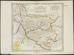
Nitiobriges : evesché d'Agen : seneschaussée d'Agenois : eslection d'Agen
7271.
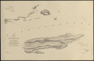
No. 3 Map of Isle Royale in Lake Superior with the adjacent shores and islands surveyed by order of the honorable the...
7272.
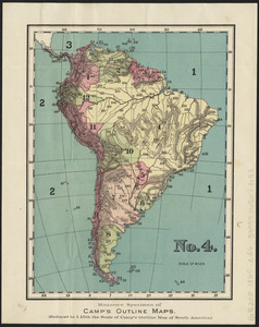
No. 4 : [South America]
7273.
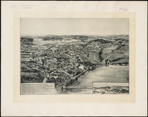
No. Chelmsford, Mass : on the Merrimac River, 1893
7274.
Nobmo. prudmoq[ue] viro Joanni Six Wimnae Toparchae, Vronmadae Domino, Consuli et Senatori Amstelaedamensi, hanc novissimam...
7275.
[Noddle Island and the Mill Pond]
7276.
Nomans Land Massachusetts : [coastal high hazard area mapping project]
7277.
Nona Asiae tabula
7278.
Nona Asie tabula continet Ariam & Paropanisadas & Drangianam & Arachosia & Gedrosiam
7279.
Nona Europa tabula continet Iaziges Metanastas
7280.
Nona Europae tabula
‹ Prev
Next ›
1
2
…
360
361
362
363
364
365
366
367
368
…
669
670


![Nobmo. prudmoq[ue] viro Joanni Six Wimnae Toparchae, Vronmadae Domino, Consuli et Senatori Amstelaedamensi, hanc novissimam Britanniae, olim Armoricae tabulam](https://bpldcassets.blob.core.windows.net/derivatives/images/commonwealth:cj82ks229/image_thumbnail_300.jpg)
![[Noddle Island and the Mill Pond]](https://bpldcassets.blob.core.windows.net/derivatives/images/commonwealth:dz010v671/image_thumbnail_300.jpg)