Toggle navigation
LMEC Home
Exhibitions
Georeferencing
Tools for Teachers
Collections
My Favorites
Sign Up / Log In
Search
Search the map portal
Map Collection
Map Collection
Map Sets
Search
Search
Search for
Search In
All Fields
Creator
Title
Subject
Place
Search All Digital Collections
Advanced Search
45 Results
My Search
Start Over
poland/
Remove constraint poland/
Filter your Search
Place
Poland
32
Europe
23
Germany
17
Russia
6
Lithuania
5
Bohemia
4
Ukraine
4
Asia
3
more
Place
»
Topic
Poland--Maps--Early works to 1800
10
Poland--Maps
8
Germany--Maps--Early works to 1800
6
Germany--Maps
5
Czech Republic--Maps--Early works to 1800
4
Swedish-Polish War, 1655-1660--Maps--Early works to 1800
4
Bohemia (Czech Republic)--Maps--Early works to 1800
3
Pomerania (Poland and Germany)--Maps--Early works to 1800
3
more
Topic
»
Date
Date range begin
–
Date range end
Current results range from
1482
to
1920
View distribution
Creator
Dahlbergh, Erik Jönsson, greve, 1625-1703
6
Pufendorf, Samuel, Freiherr von, 1632-1694
6
Riegel, Christoph
6
Wit, Frederik de.
4
Neele, Samuel John, 1758-1824
3
Ptolemy, 2nd cent
3
American Geographical Society of New York
2
La Pointe, François de
2
more
Creator
»
Format
Maps/Atlases
44
Prints
1
Georeferenced
Yes
1
No
44
Collection
Norman B. Leventhal Map Center Collection
43
Town plans, 1794
2
Urban Maps
2
Available to use
No known restrictions
45
Search Constraints
Sort by date (asc)
relevance
title
date (asc)
date (desc)
Number of results to display per page
20 per page
10
per page
20
per page
50
per page
100
per page
View results as:
grid view
map view
Search Results
41.
Large scale map of Russia in Europe
42.
Poland
43.
Poland & Lithuania
44.
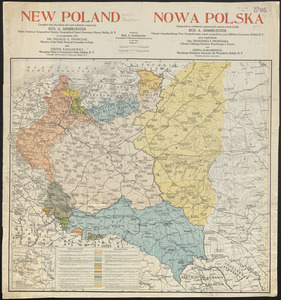
New Poland = Nowa Polska
45.
Poland
‹ Prev
Next ›
1
2
3