Toggle navigation
LMEC Home
Exhibitions
Georeferencing
Tools for Teachers
Collections
My Favorites
Sign Up / Log In
Search
Search the map portal
Map Collection
Map Collection
Map Sets
Search
Search
Search for
Search In
All Fields
Creator
Title
Subject
Place
Search All Digital Collections
Advanced Search
452 Results
My Search
Start Over
g1015
Remove constraint g1015
Filter your Search
Place
Europe
217
North and Central America
46
England
45
France
35
South America
27
Asia
26
United States
26
Germany
23
more
Place
»
Topic
Germany--Maps--Early works to 1800
14
Netherlands--Maps--Early works to 1800
10
England--Maps--Early works to 1800
9
North Rhine-Westphalia (Germany)--Maps--Early works to 1800
9
Rhineland-Palatinate (Germany)--Maps--Early works to 1800
8
South America--Maps--Early works to 1800
8
America--Maps--Early works to 1800
7
North America--Maps--Early works to 1800
7
more
Topic
»
Date
Date range begin
–
Date range end
Current results range from
1584
to
1800
View distribution
Creator
Jansson, Jan, 1588-1664
59
Wit, Frederik de.
58
Carey, Mathew, 1760-1839
49
Blaeu, Willem Janszoon, 1571-1638
46
Blaeu, Joan, 1596-1673
33
Moll, Herman, d. 1732
31
Visscher, Nicolaes, 1649-1702
26
Lea, Philip, fl. 1683-1700
24
more
Creator
»
Format
Maps/Atlases
452
Manuscripts
4
Georeferenced
Yes
27
No
425
Collection
Norman B. Leventhal Map Center Collection
452
American Revolutionary War-Era Maps
16
Boston and New England Maps
6
Maritime Charts and Atlases
5
Available to use
No known restrictions
452
Search Constraints
Sort by date (desc)
relevance
title
date (asc)
date (desc)
Number of results to display per page
20 per page
10
per page
20
per page
50
per page
100
per page
View results as:
grid view
map view
Search Results
41.
The state of North Carolina from the best authorities, &c
42.
The state of Pennsylvania : reduced with permission from Reading Howells map
43.
The state of Rhode Island : compiled from the surveys and observations of Caleb Harris
44.
The state of South Carolina : from the best authorities
45.
The state of Virginia from the best authorities
46.
Sweden, Denmark, Norway and Finland : from the best authorities
47.
Switzerland according to the best authorities
48.
Turkey, in Europe and Hungary : from the best authorities
49.
Vermont from actual survey
50.
Carte générale des états du Roi de Sardaigne, reduite d'après la grande carte : pour trouver facilement ce qu'on a envie de...
51.
To his excellency the Count of Czernichew, Commander in Chief of her Majesty the Empress, of all the Russia's fleet and...
52.
The United States of North America : with the British & Spanish territories according to the treaty
53.
The Dutch colony of the Cape of Good Hope
54.
Hindoostan
55.
A map of the King of Great Britains dominions in Germany, or, the Electorate of Brunswick-Luneburg, with its dependencies :...
56.
Plan of the bay, rock and town of Gibraltar, from an actual survey by an officer who was at Gibraltar from 1769 to 1775
57.
A chart of the British Channel and the Bay of Biscay, with a part of the North Sea, and the entrance of St. George's Channel
58.
L'Amérique divisée en ses principaux états
59.
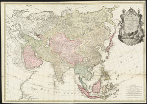
Carte de l'Asie divisée en ses principaux etats
60.
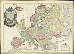
Carte de l'Europe divisée en ses principaux états
‹ Prev
Next ›
1
2
3
4
5
6
7
…
22
23